Contact | RSS | EN | DE | EL | ES | FR | IT | RU

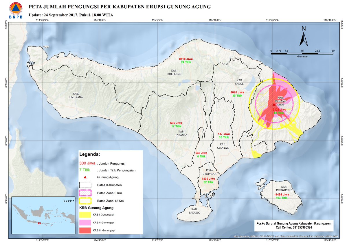
Agung volcano (Bali, Indonesia): strong explosion this morning, ash to 30,000 ft

Thu, 13 Jun 2019, 18:14 | BY: T
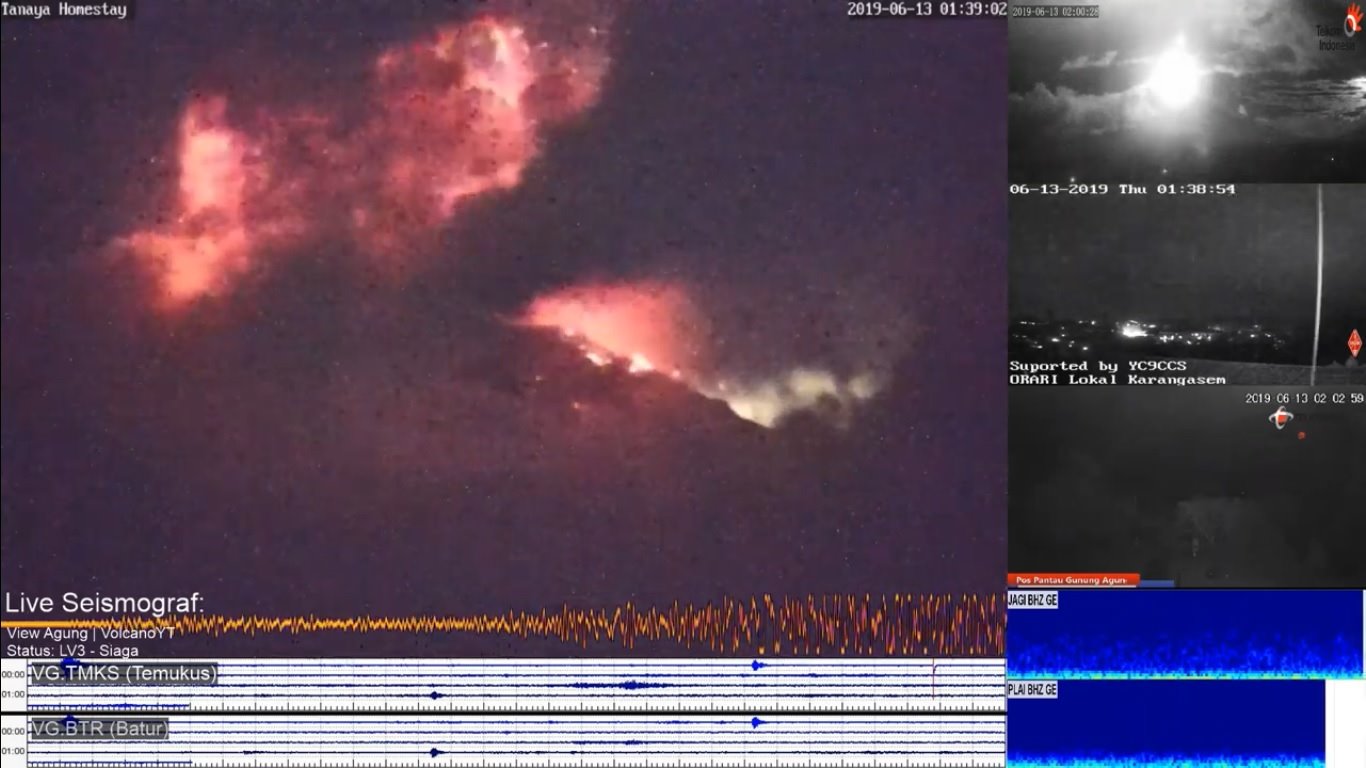
Eruption of Agung volcano this morning (image: volcanoes yt via Fb via vulkane.net)
Another explosion occurred at the volcano last night, at 01:38 local time this morning. A vulcanian-type eruption ejected lots of incandescent material to distances of at least 700 m from the crater and generated an ash plume that rose to 30,000 ft (9000 m) altitude and drifting south over Denpasar.
According to BVMBG, the eruption lasted almost 10 minutes, marking it one of the longest in the recent series of such vulcanian explosions.
A small earthquake swarm and slight inflation yesterday preceded the eruption.

At present, it is unclear whether the magma involved in the recent eruptions is the same as what had gradually accumulated in (and for a while sealed) the conduit of the volcano since the re-awakening of the volcano in 2017, or whether it is now a new, probably more fluid and hotter batch of fresh magma that has been rising from greater depths. In the latter case, an intensification of the so-far intermittent activity would be likely, while in the other case, activity would be expected to continue at similar levels and eventually gradually decline.

Previous news

Show more
Hazard map of Agung volcano (Sep 2017)
Hazard map of Agung volcano (PVMBG)
Agung volcano
Stratovolcano 3142 m (10,308 ft)
Bali (Indonesia), -8.34°S / 115.51°E
Current status: normal or dormant (1 out of 5) Agung volcano eruptions:
1808, 1821(?), 1843, 1963-64 (large Plinian eruption on March 16, 1963), 2017-ongoing
Typical eruption style
Highly explosive.
Try our free app!
Volcanoes & Earthquakes - new app for Android
Android | iOS version

More on VolcanoDiscovery

Why is there advertising on this site?

Support us - Help us upgrade our services!

We truly love working to bring you the latest volcano and earthquake data from around the world. Maintaining our website and our free apps does require, however, considerable time and resources.
We need financing to increase hard- and software capacity as well as support our editor team. We're aiming to achieve uninterrupted service wherever an earthquake or volcano eruption unfolds, and your donations can make it happen! Every donation will be highly appreciated. If you find the information useful and would like to support our team in integrating further features, write great content, and in upgrading our soft- and hardware, please make a donation (PayPal or Online credit card payment).

Planned features:Thanks to your past donations, these features have been added recently:
Download and Upgrade the Volcanoes & Earthquakes app to get one of the fastest seismic and volcano alerts online:
Android | IOS
Thank you!
Sources: VolcanoDiscovery / VolcanoAdventures and other sources as noted.
Use of material: Most text and images on our websites are owned by us. Re-use is generally not permitted without authorization. Contact us for licensing rights.
Volcanoes & Earthquakes
VolcanoDiscovery Home
Volcanoes | Earthquakes | Photos | Volcano News | App
Adventure & Study Travel
Tours to Volcanoes and Volcanic Areas: walking tours, photo tours, study tours
Tours & Dates | FAQ | About us
Get our newsletter!
Company info
Contact | Legal info | Terms & conditions
Follow us
Follow us on facebook Follow us on Instagram Follow us on Twitter Visit our Youtube channel
EN | DE | EL | ES | FR | IT | RU
VolcanoDiscovery GmbH, Germany, Reg. nr.: HRB 103744, EU Tax Id: DE 297 465 123 owned and created by
Dr. Tom Pfeiffer, volcanologist, volcano photographer, tour organizer member of
IAVCEI
IAVCEI
Vulkanologische Gesellschaft
Volcanological Society
Ecotourism Greece
Ecotourism Greece
RUV insurance
Insured by R+V
VolcanoDiscovery © 2004- All Rights Reserved | Privacy - Cookie Settings