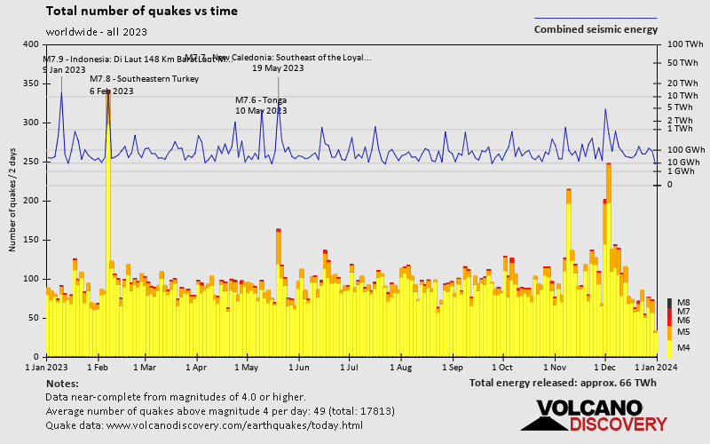
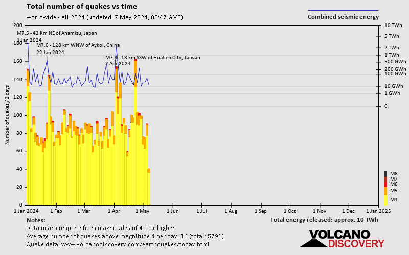
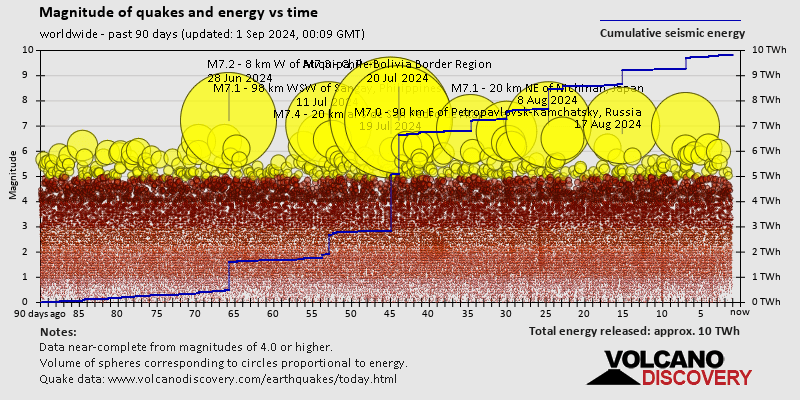
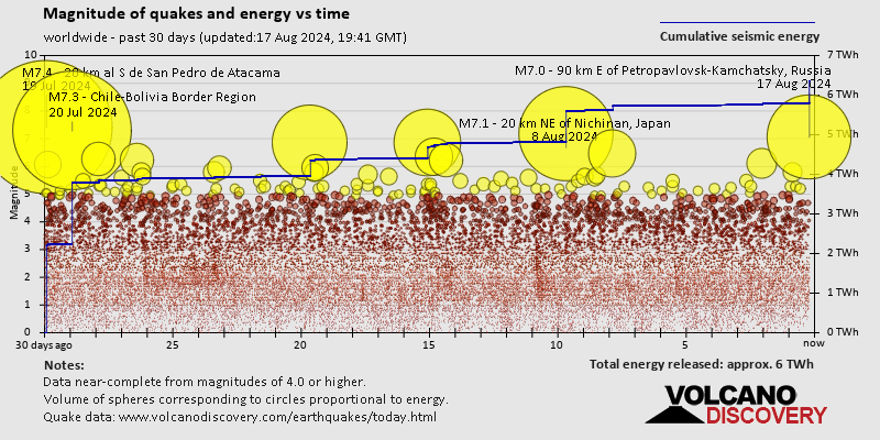
Contact | RSS | EN | DE | EL | ES | FR | IT | RU

Latest quakes near Awu volcano since 2020 - list, stats and map

Updated: Apr 25, 2024 06:36 GMT -
Find all latest earthquakes near Awu volcano in our list below, updated every minute! Events are often reported within minutes. If you just felt a quake near Awu volcano, find out which quakes are happening right now!
There were no significant confirmed earthquakes near Awu volcano in the past 7 days.
Since 2020, Awu volcano has had 21 quakes of magnitudes above 2 and up to 5.0:
  • 1 quake above magnitude 5
  • 4 quakes between magnitude 4 and 5
  • 15 quakes between magnitude 3 and 4
  • 1 quake between magnitude 2 and 3
Number of quakes per year
Read more
[smaller] [bigger]

Quakes, magnitude and depth over time

Past 48 hrs
Past 7 days
14 days
30 days
1 year
Earthquake depth plot
Depth and magnitude of quakes over time
Earthquake depth plot
Depth and magnitude of quakes over time
Earthquake depth plot
Depth and magnitude of quakes over time
Earthquake depth plot
Depth and magnitude of quakes over time
Earthquake depth plot
Depth and magnitude of quakes over time
Filter by magnitude:
all
3.0+
4.0+
5.0+
Check for new quakes now!
in sec
Pause automatic refreshing
Showing all recent or significant quakes since 2020, magnitude 0 or higher, within up to 30 km (19 mi) distance (21 quakes):
Latest quakes near Awu volcano since 2020 - list, stats and map
Date and TimeMag
Depth
DistanceLocationDetailsMap
Sep 21, 2023 04:27 am (Makassar)
3.2

68 km
13 km (7.9 mi) to the N Indonesia: 181 Km S 02° E of Balut Island (Municipality Of Sarangani) (Davao Occidental)
Info
Thursday, September 7, 2023 GMT (1 quake)
Sep 7, 2023 10:29 am (Makassar)
3.1

9 km
26 km (16 mi) to the NW Indonesia: 180 Km S 04° W of Balut Island (Municipality Of Sarangani) (Davao Occidental)
Info
Wednesday, August 16, 2023 GMT (1 quake)
Aug 16, 2023 10:31 am (Makassar)
4.7

88 km
27 km (17 mi) to the E Philippine Sea, 21 km east of Sangihe Besar Island, North Sulawesi, Indonesia
Info
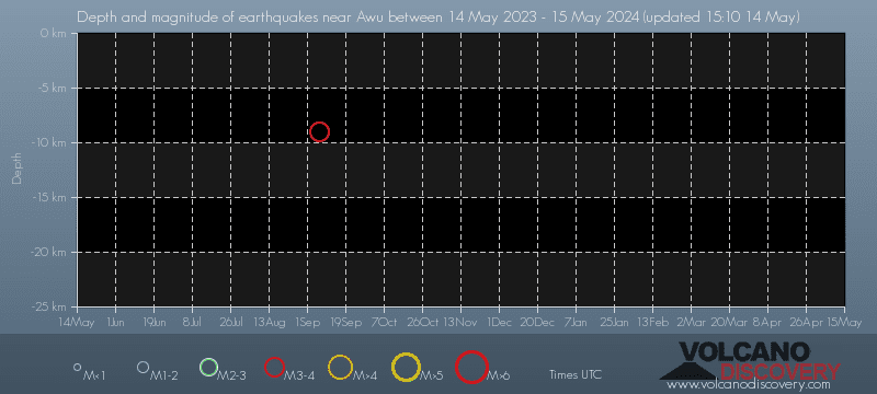
Thursday, May 25, 2023 GMT (1 quake)
May 26, 2023 02:25 am (Makassar)
3.7

109 km
20 km (13 mi) to the S Indonesia: 212 Km S 01° E of Balut Island (Municipality Of Sarangani) (Davao Occidental)
Info
Wednesday, January 18, 2023 GMT (1 quake)
Jan 18, 2023 09:41 am (Makassar)
3.8

151 km
25 km (15 mi) to the SE KEPULAUAN SANGIHE, INDONESIA
Info
Monday, October 3, 2022 GMT (1 quake)
Oct 3, 2022 09:06 am (Makassar)
3.6

96 km
22 km (14 mi) to the S Indonesia: 214 Km S 01° E of Balut Island (Municipality Of Sarangani) (Davao Occidental)
Info
Wednesday, August 31, 2022 GMT (1 quake)
Aug 31, 2022 08:25 pm (Makassar)
4.2

143 km
16 km (9.8 mi) to the SE 201 km S of Sarangani, Philippines
Info
Tuesday, March 1, 2022 GMT (1 quake)
Mar 1, 2022 03:30 pm (Makassar)
3.6

33 km
23 km (15 mi) to the NE Indonesia: 183 Km S 09° E of Balut Island (Municipality Of Sarangani) (Davao Occidental)
Info
Sunday, January 30, 2022 GMT (1 quake)
Jan 30, 2022 05:58 pm (Makassar)
3.6

33 km
28 km (17 mi) to the NE Indonesia: 180 Km S 10° E of Balut Island (Municipality Of Sarangani) (Davao Occidental)
Info
Thursday, September 16, 2021 GMT (1 quake)
Sep 16, 2021 11:57 am (Makassar)
3.2

135 km
29 km (18 mi) to the NE Indonesia: 171 Km S 09° E of Sarangani (Davao Occidental)
Info
Monday, June 28, 2021 GMT (1 quake)
Jun 28, 2021 11:06 pm (Makassar)
4.0

120 km
20 km (12 mi) to the NE KEPULAUAN SANGIHE, INDONESIA
Info
Show more
About these data
Estimated combined seismic energy released: 3.4 x 10¹² joules (946 megawatt hours, equivalent to 814 tons of TNT) | about seismic energy

Earthquake Catalog - Look up past earthquakes

Look up past earthquakes in this area by date or date range:
or
Look up quakes!
Felt a quake? Report it!
Show quakes near me!

Earthquake statistics

Number of quakes per year

Note:
The apparent increase in the number of quakes is not because global seismic activity has increased, but because the number of seismic networks around the world and their sensitivity to detect smaller quakes has been constantly increasing.
This is most evident if one looks at the number of smaller earthquakes (below magnitude 5). For larger quakes (magnitude 5 or more), the effect disappears after around the 1990s. Since then, the global coverage of earthquake of larger quakes has been nearly complete.

Average number of earthquakes

Based on data from the past 54 years and our earthquake archive back to 1900, there are about 4.6 quakes on average per year near Awu volcano:
  • Mag. 5 or higher: 0.14 quakes per year (or 1 quake every 7.2 years)
  • Mag. 4 or higher: 0.71 quakes per year (or 1 quake every 1.4 years)
  • Mag. 3 or higher: 2.3 quakes per year
  • Mag. 2 or higher: 2.5 quakes per year

Number of earthquakes over time

Past 90 days
30 days
7 days
24 hours
2023
2024 so far
Number of earthquakes over time: Past 90 days
Number of earthquakes over time: 30 days
Number of earthquakes over time: 7 days
Number of earthquakes over time: 24 hours
Number of earthquakes over time: 2023
Number of earthquakes over time: 2024 so far

Magnitude and seismic energy over time

Past 90 days
30 days
7 days
24 hours
2023
2024 so far
Magnitude and seismic energy over time: Past 90 days
Magnitude and seismic energy over time: 30 days
Magnitude and seismic energy over time: 7 days
Magnitude and seismic energy over time: 24 hours
Magnitude and seismic energy over time: 2023
Magnitude and seismic energy over time: 2024 so far

Magnitude and energy distribution

Past 90 days
30 days
7 days
24 hours
2023
2024 so far
Magnitude and energy distribution: Past 90 days
Magnitude and energy distribution: 30 days
Magnitude and energy distribution: 7 days
Magnitude and energy distribution: 24 hours
Magnitude and energy distribution: 2023
Magnitude and energy distribution: 2024 so far

Embed or share standalone map

You can use the standalone version of our interactive earthquake map or embed it on your website:
Wed, 17 Apr 2024, 14:00

Awu volcano (Sangihe Islands) - Smithsonian / USGS Weekly Volcanic Activity Report for 10 April-16 April 2024 (New Activity / Unrest)

PVMBG reported that an increase in both deep and shallow volcanic earthquakes at Awu were recorded on 22 March and again during 10-15 April. Tiltmeter data from two stations recorded inflation during 1 March-16 April. The Alert Level was raised to 3 (on a scale of 1-4) at 1800 on 16 April and the public was warned to stay at least 5 km away from the crater's center. ... Read all
Wed, 7 Feb 2024, 15:00

Awu volcano (Sangihe Islands) - Smithsonian / USGS Weekly Volcanic Activity Report for 31 January-6 February 2024 (Continuing Activity)

In a press release for Awu, PVMBG reported that both the number and intensity of earthquake events increased during 29-31 January; the signals possibly indicated the movement of magma to shallower depths. Inflation had been recorded since June 2023 and was ongoing. The Alert Level remained at 2 (on a scale of 1-4), and the public was warned to stay at least 3 km away from the summit crater. ... Read all
Try our free app!
Volcanoes & Earthquakes - new app for Android
Android | iOS version

More on VolcanoDiscovery

Why is there advertising on this site?

Support us - Help us upgrade our services!

We truly love working to bring you the latest volcano and earthquake data from around the world. Maintaining our website and our free apps does require, however, considerable time and resources.
We need financing to increase hard- and software capacity as well as support our editor team. We're aiming to achieve uninterrupted service wherever an earthquake or volcano eruption unfolds, and your donations can make it happen! Every donation will be highly appreciated. If you find the information useful and would like to support our team in integrating further features, write great content, and in upgrading our soft- and hardware, please make a donation (PayPal or Online credit card payment).

Planned features:Thanks to your past donations, these features have been added recently:
Download and Upgrade the Volcanoes & Earthquakes app to get one of the fastest seismic and volcano alerts online:
Android | IOS
Thank you!
Sources: VolcanoDiscovery / VolcanoAdventures and other sources as noted.
Use of material: Most text and images on our websites are owned by us. Re-use is generally not permitted without authorization. Contact us for licensing rights.
Volcanoes & Earthquakes
VolcanoDiscovery Home
Volcanoes | Earthquakes | Photos | Volcano News | App
Adventure & Study Travel
Tours to Volcanoes and Volcanic Areas: walking tours, photo tours, study tours
Tours & Dates | FAQ | About us
Get our newsletter!
Company info
Contact | Legal info | Terms & conditions
Follow us
Follow us on facebook Follow us on Instagram Follow us on Twitter Visit our Youtube channel
EN | DE | EL | ES | FR | IT | RU
VolcanoDiscovery GmbH, Germany, Reg. nr.: HRB 103744, EU Tax Id: DE 297 465 123 owned and created by
Dr. Tom Pfeiffer, volcanologist, volcano photographer, tour organizer member of
IAVCEI
IAVCEI
Vulkanologische Gesellschaft
Volcanological Society
Ecotourism Greece
Ecotourism Greece
RUV insurance
Insured by R+V
VolcanoDiscovery © 2004- All Rights Reserved | Privacy - Cookie Settings