Official end of eruption declared 28 Feb 2015
At noon of the 28th of February, the Scientific Advisory Board for Iceland´s recent volcanic activity officially declared that the eruption at Holuhraun has come to an end.
Eruption continues, but decreases
Update Mon 16 Feb 10:37

Photo of the lava lake at Holuhraun on 12 Feb (photo: Ármann Höskuldsson / Univ. Iceland)
The eruption at Holuhraun continues at similar levels as lately, the Icelandic Met Office reports in its updates. The decreasing trend, however, is becoming visible in a significant drop of the lava lake level inside the Baugur crater above the main vents, seen in the photo above.
"From the field 12 Feb 2015; view from the rim of the southern crater into the lava lake of Baugur. In the foreground, 400m away from the rim, is the southern magma vent. Beyond that there is the northern magma vent, boiling. The lava lake in the foreground is not only glowing; the blackish cover next to the rim indicates some cold crust on its surface, whereas the orange colour reveals liquid magma. Photo: Ármann Höskuldsson. See more photos in a
field report from the Institute of Earth Sciences" (Icelandic Met Office).
Update: eruption could go on for many months
Update Tue 03 Feb 07:08
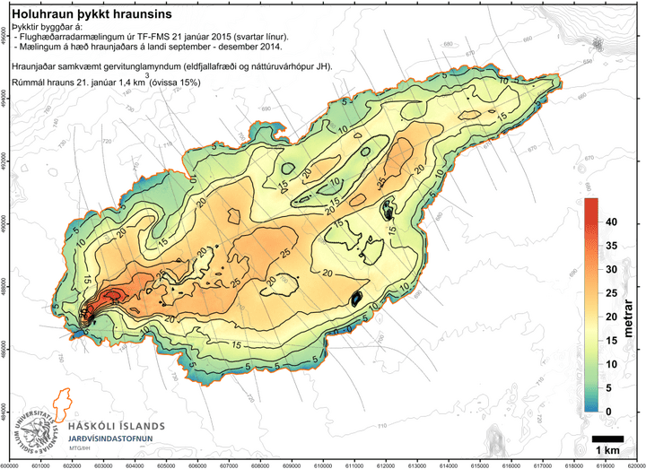
Thickness map of the Holuhraun lava flow field (Scientific Advisory Board)
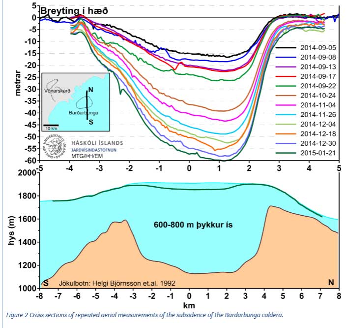
Caldera subsidence over the past months (Scientific Advisory Board)
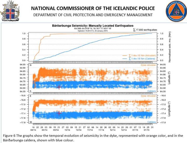
Seismic activity under the dyke (IMO) and the Bárðarbunga caldera (blue) (Scientific Advisory Board)
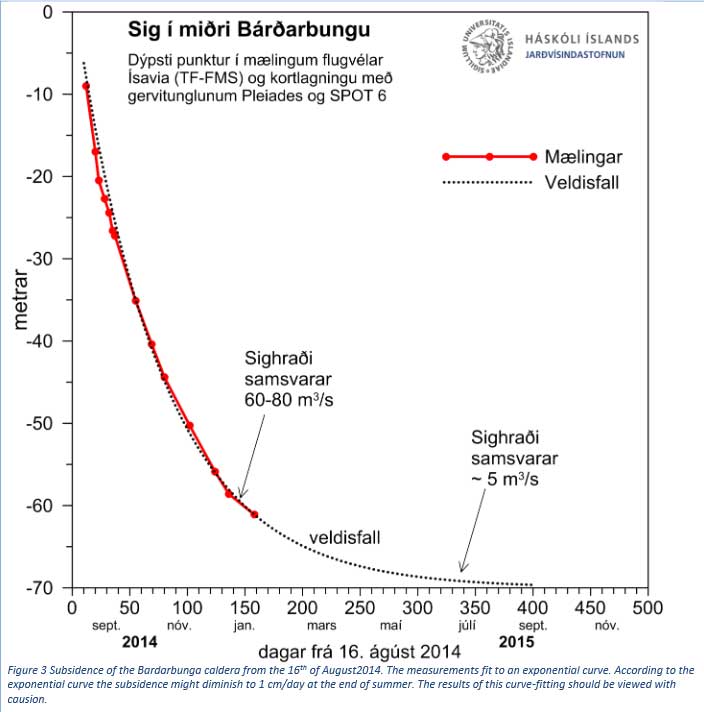
Graph showing the measured and extrapolated subsidence of the caldera (Scientific Advisory Board)
The eruption, now going on for more than 150 days, continues with little changes. Although it has started to decrease, very slowly, in intensity, it remains impressive and magma discharge is still an impressive approx. 100 cubic meters per second.
Caldera subsidence and seismicity continue as well, but a slow decreasing trend of subsidence rate - from initially 50 cm a day to now about half of that now - is visible as well and seems to correlated with the decrease in magma effusion. Icelandic scientists think therefore that subsidence (and hence, the eruption,) might go on for another 5 to 16 months.
The
latest report by the Scientific Advisory Board gives a detailed overview, summarized here:
The above prediction, based on extrapolation of measurements and simple models, must be seen with caution:
"It is entirely possible that the eruption will end sooner than predicted above. It is also possible that the eruption could become stable and go on for years, but with a greatly reduced magma flow rate.
An eruption in Bardarbunga is still possible even though the development described above will continue. Even though the volcanic eruption in Holuhraun stops in the coming months it is not certain that the current rifting episode is at an end. It is still possible that an eruption may start on another part of the fissure swarm within the Bardarbunga volcanic system."
"... Three scenarios are considered most likely:
1) The eruption in Holuhraun continues until the subsidence of the Bardarbunga caldera stops. The eruption can still go on for many months.
2) The volcanic fissure may lengthen southwards under Dyngjujokull, resulting in a jokulhlaup and an ash-producing eruption. It is also possible that eruptive fissures could develop in another location under the glacier. If such an eruption would be prolonged it could eventually produce a lava flow.
3) Volcanic eruption in the Bardarbunga caldera. Such an eruption would melt large quantities of ice, leading to a major jokulhlaup, accompanied by ash fall.
Other scenarios cannot be excluded."
Finally, here's an impression from the eruption site in the past days, showing the still large river of lava issuing from the Baugur crater:
Small subglacial eruption ?
Update Fri 30 Jan 11:45

Earthquakes at Bardarbunga yesterday (IMO)
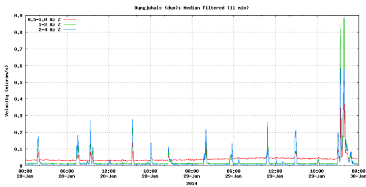
Tremor amplitude at DYN station showing the peak during the possible eruption(IMO)
A small earthquake swarm at 1 km below the eastern rim of the Bardarbunga caldera occurred yesterday evening at 21:22 local time, accompanied by a rise in tremor.
John Friman who closely follows the events in Iceland suspects on
his blog that a minor subglacial eruption could have taken place.
If so, a meltwater flood should be expected in the course of the day.
Eruption decreases
Update Wed 28 Jan 17:52
The visible intensity of the eruption continues to decrease gradually. The Icelandic Met office conducted air-borne measurements of the lava field last week, showing that it has significantly thickened (rather than expanded laterally) during the past weeks, and is now estimated to contain approx. 1.4 cubic kilometers of lava. Effusion rates, although decreasing, are still close to an impressive 100 m³ per second.
Comparison of the Baugur vent showing the decrease in activity (photo: Morten S.Riishuus & Ármann Höskuldsson / IES FVNH)
Details of the aerial observations on 21 Jan
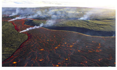
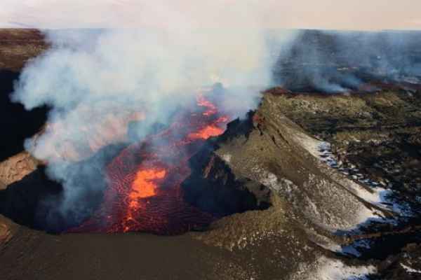
Photo of the active channels to the east (left and foreground) and northeast (right and middle ground) on 21 Jan (photo: Morten S.Riishuus & Ármann Höskuldsson / IES FVNH)
:
The activity of rising gas bubbles in the lava lake has strongly diminished and the level of the lava lake has dropped. It now stands at the lowest level since it formed.
The large northern lava channel that had formed in mid December is no longer active. Apparently, the drop in effusion rate is no longer able to sustain such a wide channel.
Lava now flows into closed channels to the east and northeast. The northeastern channel continues to feed a modest active lobe that advances towards the road junction at Thorvaldshraun. The eastern channel feeds active breakouts at the far eastern edge of the lava field near Jökulsá and otherwise mostly contributes to thickening of the lava field, riddled with tumulus structures (inflated parts), collapse pits, abandoned channels and tunnels and hornitos above skylights.
Eruption continues with slowly decreasing trend
Update Fri 23 Jan 17:42
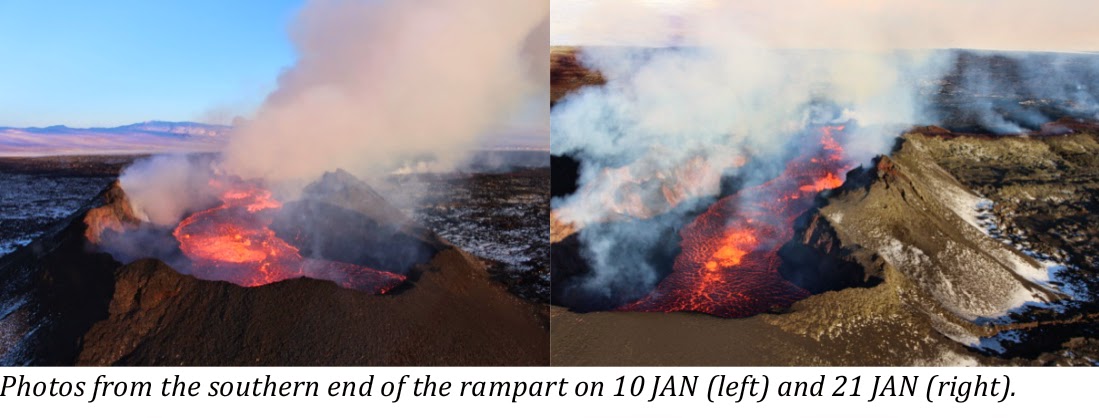
The southern end of the rampart; surveillance flight with the Icelandic Coast Guard 21 January 2015. Various measurements were made and the results will be published shortly. Photo: Morten S. Riishuus.(IMO)
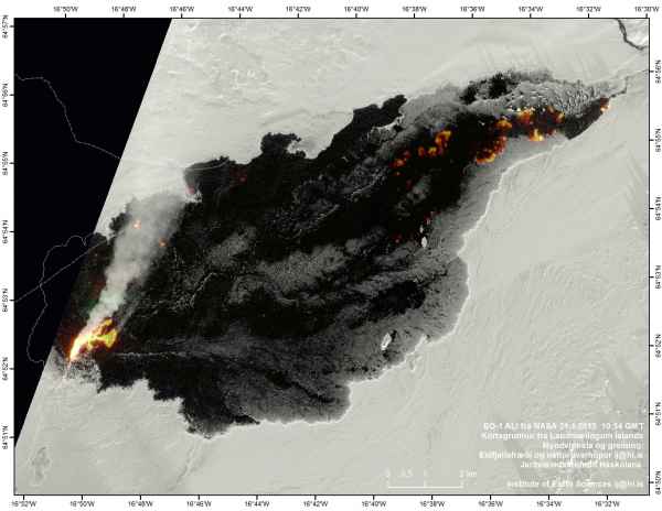
NASA EO-1 image from 21.Jan 2015, processed by the Institute of Earth Sciences. (IMO)
No significant changes in seismic and volcanic activity have occurred recently at the ongoing Holuhraun eruption, but overall, a slowly decreasing trend of the activity is becoming evident. Still, magma effusion remains quite impressive, especially the large lava lake inside Baugur crater on the main part of the fissure.
Although still elevated, the average number of larger earthquakes under the caldera is decreasing slowly.
Predicting the end of the eruption in March 2015
Update Mon 19 Jan 14:29
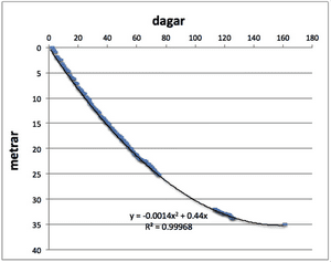
Observed caldera subsidence versus time - if the modeled curve is correct, it should flatten out in March this year and might mean the end of the eruption (source: visir.is)
According to Icelandic volcanologist Haraldur Sigurðsson, it is reasonable to predict that the eruption might be ending in March this year.
This audacious prediction is based on extrapolating the observed ongoing slow subsidence ("collapse") of the central volcano's caldera floor, located under 800 m of ice, and assuming that it is a direct indicator of the magma erupted at the Holuhraun fissure.
The underlying model is based on a number of assumptions:
- magma from the reservoir underneath the caldera is drained through a 50 km long underground "tunnel" (more likely a fissure-like feature) to the eruption site
- the evacuated volume corresponds more or less to the one erupted.
- the subsidence of the caldera is a result of pressure adjustment in the magma chamber. Once the pressure in the magma chamber reaches a balance (equals out with lithostatic pressure, i.e. the weight of the overlying rocks and ice), the caldera subsidence and supply of magma to the eruption site would stop.
- the observed rate of subsidence is amazingly regular and therefore it is reasonable that it can be extrapolated using a best-fit mathematical curve.
Using this approach, the rate of caldera subsidence is modeled as a simple square-function curve that flattens out in March. That would imply a pressure equilibrium in the magma chamber and the end of magma supply, hence the end of the eruption.
The volcano and time will tell whether this prediction holds!
Source: Volcanoist has calculated when the eruption will end (Visir.Is)
First visit to our site? If you havn't done it yet,
download the Volcanoes & Earthquakes app to get one of the fastest volcano news online:
Android |
IOS


