Contact | RSS | EN | DE | EL | ES | FR | IT | RU

Bogoslof volcano (Aleutian Islands): larger explosive eruption on 10 June, ash to 34,000 ft

Sun, 11 Jun 2017, 12:05 | BY: T
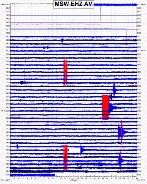
An explosive eruption occurred from about 3:18 to 5:28 local time AKDT (11:18 to 13:28 UTC) on 10 June. This sequence began with a series of short infrasound signals and then, starting at about 4:16 AKDT (12:16 UTC), transitioned into several minutes-long continuous seismic and infrasound tremor signals.
Satellite images of the resulting cloud show it reached as high as 34,000 ft asl and drifted to the northwest. Satellite data also indicate that at least part of the volcanic cloud was more ash-rich than most of those seen previously in the Bogoslof eruptive sequence to date. This suggests that the eruption may have destroyed the lava dome that was emplaced earlier this week.
Since 5:28 AKDT (13:28 UTC), seismicity as detected on neighboring islands has been quiet, no lightning has been detected, and satellite images show no additional emission from the volcano.
Bogoslof volcano remains at a heightened state of unrest and in an unpredictable condition. Additional explosions producing high-altitude volcanic clouds could occur at any time. Low-level explosive activity that is below our ability to detect in our data sources may be occurring. These low-level explosions could pose a hazard in the immediate vicinity of the volcano.
(AVO)

Previous news

Show more
Bogoslof volcano
Submarine volcano 150 m / 492 ft
United States, Aleutian Islands, 53.93°N / -168.03°W
Current status: normal or dormant (1 out of 5) Bogoslof volcano eruptions:
2016-17, 1992, 1951 (?), 1931 (?), 1926-28, 1913, (?), 1909-10, 1908 (?), 1907, 1906, 1883, 1806, 1786
Typical eruption style
explosive
Try our free app!
Volcanoes & Earthquakes - new app for Android
Android | iOS version

More on VolcanoDiscovery

Why is there advertising on this site?

Support us - Help us upgrade our services!

We truly love working to bring you the latest volcano and earthquake data from around the world. Maintaining our website and our free apps does require, however, considerable time and resources.
We need financing to increase hard- and software capacity as well as support our editor team. We're aiming to achieve uninterrupted service wherever an earthquake or volcano eruption unfolds, and your donations can make it happen! Every donation will be highly appreciated. If you find the information useful and would like to support our team in integrating further features, write great content, and in upgrading our soft- and hardware, please make a donation (PayPal or Online credit card payment).

Planned features:Thanks to your past donations, these features have been added recently:
Download and Upgrade the Volcanoes & Earthquakes app to get one of the fastest seismic and volcano alerts online:
Android | IOS
Thank you!
Sources: VolcanoDiscovery / VolcanoAdventures and other sources as noted.
Use of material: Most text and images on our websites are owned by us. Re-use is generally not permitted without authorization. Contact us for licensing rights.
Volcanoes & Earthquakes
VolcanoDiscovery Home
Volcanoes | Earthquakes | Photos | Volcano News | App
Adventure & Study Travel
Tours to Volcanoes and Volcanic Areas: walking tours, photo tours, study tours
Tours & Dates | FAQ | About us
Get our newsletter!
Company info
Contact | Legal info | Terms & conditions
Follow us
Follow us on facebook Follow us on Instagram Follow us on Twitter Visit our Youtube channel
EN | DE | EL | ES | FR | IT | RU
VolcanoDiscovery GmbH, Germany, Reg. nr.: HRB 103744, EU Tax Id: DE 297 465 123 owned and created by
Dr. Tom Pfeiffer, volcanologist, volcano photographer, tour organizer member of
IAVCEI
IAVCEI
Vulkanologische Gesellschaft
Volcanological Society
Ecotourism Greece
Ecotourism Greece
RUV insurance
Insured by R+V
VolcanoDiscovery © 2004- All Rights Reserved | Privacy - Cookie Settings