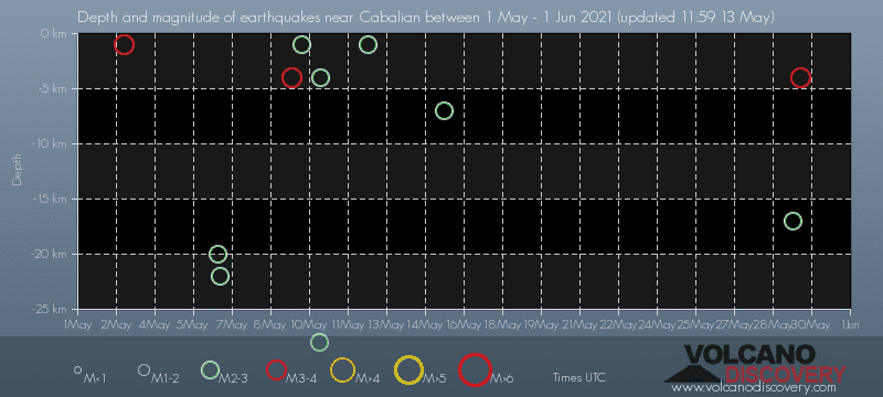
Contact | RSS | EN | DE | EL | ES | FR | IT | RU

Past earthquakes near Cabalian volcano: May 2021 - list, stats and map

Updated: Apr 20, 2024 04:32 GMT -
During May 2021, Cabalian volcano has had 14 quakes of magnitudes up to 3.8:
  • 3 quakes above magnitude 3
  • 10 quakes between magnitude 2 and 3
  • 1 quake below magnitude 2 that people normally don't feel.
Strongest: Mag. 3.8 Earthquake 007 Km S 59° E of San Francisco (Southern Leyte), Philippines -
[smaller] [bigger]

Quakes, magnitude and depth over time

Earthquake depth plot
Depth and magnitude of quakes over time
Filter by magnitude:
all
2.0+
3.0+
Showing quakes magnitude 0.5 or higher, within up to 30 km (19 mi) distance (14 quakes):
Past earthquakes near Cabalian volcano: May 2021 - list, stats and map
Date and TimeMag
Depth
DistanceLocationDetailsMap
May 30, 2021 08:35 am (Manila)
3.2

4 km
26 km (16 mi) to the NW Philippines: 012 Km S 58° W of Silago (Southern Leyte)
Info
Saturday, May 29, 2021 GMT (1 quake)
May 30, 2021 12:31 am (Manila)
2.0

17 km
22 km (14 mi) to the S Philippines: 006 Km N 42° E of San Francisco (Southern Leyte)
Info
Saturday, May 15, 2021 GMT (1 quake)
May 16, 2021 12:52 am (Manila)
2.6

7 km
5.9 km (3.6 mi) to the NW 007 Km S 69° W of Hinundayan (Southern Leyte), Philippines
Info
Wednesday, May 12, 2021 GMT (1 quake)
May 12, 2021 11:37 pm (Manila)
2.6

1 km
28 km (17 mi) to the W 002 Km N 40° W of Tomas Oppus (Southern Leyte), Philippines
Info
Monday, May 10, 2021 GMT (2 quakes)
May 11, 2021 02:03 am (Manila)
2.5

4 km
6.2 km (3.9 mi) to the N 001 Km S 48° W of Hinundayan (Southern Leyte), Philippines
Info
May 11, 2021 12:36 am (Manila)
2.4

28 km
14 km (8.9 mi) to the NW 007 Km S 75° W of Hinunangan (Southern Leyte), Philippines
Info
Sunday, May 9, 2021 GMT (4 quakes)
May 10, 2021 07:57 am (Manila)
2.1

1 km
19 km (12 mi) to the NW 010 Km N 76° W of Hinunangan (Southern Leyte), Philippines
Info
May 10, 2021 02:02 am (Manila)
2.0

33 km
27 km (17 mi) to the S 013 Km S 86° E of San Francisco (Southern Leyte), Philippines
Info
May 9, 2021 10:48 pm (Manila)
1.8

34 km
12 km (7.5 mi) to the S 016 Km N 34° E of San Francisco (Southern Leyte), Philippines
Info
May 9, 2021 09:48 pm (Manila)
3.8

4 km
29 km (18 mi) to the S 007 Km S 59° E of San Francisco (Southern Leyte), Philippines 1 report
Info
Thursday, May 6, 2021 GMT (2 quakes)
May 7, 2021 01:03 am (Manila)
2.0

22 km
14 km (8.9 mi) to the NW 009 Km S 73° W of Hinunangan (Southern Leyte), Philippines
Info
Show more
About these data
Estimated combined seismic energy released: 4.2 x 10¹⁰ joules (11.6 megawatt hours, equivalent to 9.99 tons of TNT) | about seismic energy

Earthquake Catalog - Look up past earthquakes

Look up past earthquakes in this area by date or date range:
or
Look up quakes!
Felt a quake? Report it!
Show quakes near me!

Earthquake statistics

Number of earthquakes over time

during May 2021
in 2021
Number of earthquakes over time: during May 2021
Number of earthquakes over time: in 2021

Magnitude and seismic energy over time

during May 2021
in 2021
Magnitude and seismic energy over time: during May 2021
Magnitude and seismic energy over time: in 2021

Magnitude and energy distribution

during May 2021
in 2021
Magnitude and energy distribution: during May 2021
Magnitude and energy distribution: in 2021

Embed or share standalone map

You can use the standalone version of our interactive earthquake map or embed it on your website:

No news in this list.

Try our free app!
Volcanoes & Earthquakes - new app for Android
Android | iOS version

More on VolcanoDiscovery

Why is there advertising on this site?

Support us - Help us upgrade our services!

We truly love working to bring you the latest volcano and earthquake data from around the world. Maintaining our website and our free apps does require, however, considerable time and resources.
We need financing to increase hard- and software capacity as well as support our editor team. We're aiming to achieve uninterrupted service wherever an earthquake or volcano eruption unfolds, and your donations can make it happen! Every donation will be highly appreciated. If you find the information useful and would like to support our team in integrating further features, write great content, and in upgrading our soft- and hardware, please make a donation (PayPal or Online credit card payment).

Planned features:Thanks to your past donations, these features have been added recently:
Download and Upgrade the Volcanoes & Earthquakes app to get one of the fastest seismic and volcano alerts online:
Android | IOS
Thank you!
Sources: VolcanoDiscovery / VolcanoAdventures and other sources as noted.
Use of material: Most text and images on our websites are owned by us. Re-use is generally not permitted without authorization. Contact us for licensing rights.
Volcanoes & Earthquakes
VolcanoDiscovery Home
Volcanoes | Earthquakes | Photos | Volcano News | App
Adventure & Study Travel
Tours to Volcanoes and Volcanic Areas: walking tours, photo tours, study tours
Tours & Dates | FAQ | About us
Get our newsletter!
Company info
Contact | Legal info | Terms & conditions
Follow us
Follow us on facebook Follow us on Instagram Follow us on Twitter Visit our Youtube channel
EN | DE | EL | ES | FR | IT | RU
VolcanoDiscovery GmbH, Germany, Reg. nr.: HRB 103744, EU Tax Id: DE 297 465 123 owned and created by
Dr. Tom Pfeiffer, volcanologist, volcano photographer, tour organizer member of
IAVCEI
IAVCEI
Vulkanologische Gesellschaft
Volcanological Society
Ecotourism Greece
Ecotourism Greece
RUV insurance
Insured by R+V
VolcanoDiscovery © 2004- All Rights Reserved | Privacy - Cookie Settings