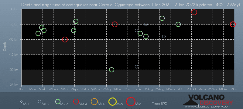
Contact | RSS | EN | DE | EL | ES | FR | IT | RU

Past earthquakes near Cerro el Ciguatepe volcano: 2021 - list, stats and map

Updated: Apr 19, 2024 05:53 GMT -
In 2021, Cerro el Ciguatepe volcano has had 26 quakes of magnitudes up to 4.2:
  • 1 quake above magnitude 4
  • 7 quakes between magnitude 3 and 4
  • 13 quakes between magnitude 2 and 3
  • 5 quakes below magnitude 2 that people normally don't feel.
Strongest: Mag. 4.2 Earthquake 28 Km Al Noroeste De Teustepe, Nicaragua -
[smaller] [bigger]

Quakes, magnitude and depth over time

Earthquake depth plot
Depth and magnitude of quakes over time
Filter by magnitude:
all
2.0+
3.0+
4.0+
Showing quakes magnitude 0.5 or higher, within up to 30 km (19 mi) distance (26 quakes):
Past earthquakes near Cerro el Ciguatepe volcano: 2021 - list, stats and map
Date and TimeMag
Depth
DistanceLocationDetailsMap
Dec 30, 2021 10:52 pm (Managua)
2.4

38 km
10.8 km (6.7 mi) to the NE 27 Km Al Norte De San Francisco Libre, Nicaragua
Info
Thursday, December 30, 2021 GMT (2 quakes)
Dec 30, 2021 01:24 pm (Managua)
3.8

5 km
29 km (18 mi) to the NW 22 Km Al Norte De San Francisco Libre, Nicaragua
Info
Dec 30, 2021 11:19 am (Managua)
3.6

5 km
16 km (10.2 mi) to the SW NICARAGUA
Info
Wednesday, December 29, 2021 GMT (1 quake)
Dec 29, 2021 12:44 pm (Managua)
4.2

267 km
18 km (11 mi) to the E 28 Km Al Noroeste De Teustepe, Nicaragua
Info
Monday, October 25, 2021 GMT (1 quake)
Oct 25, 2021 06:11 am (Managua)
3.0

1 km
23 km (14 mi) to the S 18 Km Al Noroeste De Tipitapa, Nicaragua
Info
Sunday, October 3, 2021 GMT (1 quake)
Oct 3, 2021 03:39 pm (Managua)
3.0

165 km
10.7 km (6.7 mi) to the SE 26 Km Al Norte De San Francisco Libre, Nicaragua
Info
Monday, September 27, 2021 GMT (1 quake)
Sep 27, 2021 01:42 pm (Managua)
2.4

5 km
28 km (17 mi) to the W 11 Km Al Oeste De San Francisco Libre, Nicaragua
Info
Wednesday, September 8, 2021 GMT (1 quake)
Sep 7, 2021 08:29 pm (Managua)
3.1

36 km
17 km (10.5 mi) to the NW 11 Km Al Norte De San Francisco Libre, Nicaragua
Info
Friday, September 3, 2021 GMT (1 quake)
Sep 3, 2021 02:40 am (Managua)
1.6

9 km
27 km (17 mi) to the S 12 Km Al Norte De Tipitapa, Nicaragua
Info
Tuesday, August 31, 2021 GMT (1 quake)
Aug 30, 2021 08:46 pm (Managua)
2.9

3 km
22 km (14 mi) to the SW 16 Km Al Noreste De Laguna De Apoyeque, Nicaragua
Info
Monday, August 9, 2021 GMT (1 quake)
Aug 9, 2021 03:08 pm (Managua)
2.8

40 km
22 km (14 mi) to the NW 17 Km Al Norte De San Francisco Libre, Nicaragua
Info
Show more
About these data
Estimated combined seismic energy released: 2 x 10¹¹ joules (54.3 megawatt hours, equivalent to 46.7 tons of TNT) | about seismic energy

Earthquake Catalog - Look up past earthquakes

Look up past earthquakes in this area by date or date range:
or
Look up quakes!
Felt a quake? Report it!
Show quakes near me!

Earthquake statistics

Number of earthquakes over time

in 2021
Number of earthquakes over time: in 2021

Magnitude and seismic energy over time

in 2021
Magnitude and seismic energy over time: in 2021

Magnitude and energy distribution

in 2021
Magnitude and energy distribution: in 2021

Embed or share standalone map

You can use the standalone version of our interactive earthquake map or embed it on your website:

No news in this list.

Try our free app!
Volcanoes & Earthquakes - new app for Android
Android | iOS version

More on VolcanoDiscovery

Why is there advertising on this site?

Support us - Help us upgrade our services!

We truly love working to bring you the latest volcano and earthquake data from around the world. Maintaining our website and our free apps does require, however, considerable time and resources.
We need financing to increase hard- and software capacity as well as support our editor team. We're aiming to achieve uninterrupted service wherever an earthquake or volcano eruption unfolds, and your donations can make it happen! Every donation will be highly appreciated. If you find the information useful and would like to support our team in integrating further features, write great content, and in upgrading our soft- and hardware, please make a donation (PayPal or Online credit card payment).

Planned features:Thanks to your past donations, these features have been added recently:
Download and Upgrade the Volcanoes & Earthquakes app to get one of the fastest seismic and volcano alerts online:
Android | IOS
Thank you!
Sources: VolcanoDiscovery / VolcanoAdventures and other sources as noted.
Use of material: Most text and images on our websites are owned by us. Re-use is generally not permitted without authorization. Contact us for licensing rights.
Volcanoes & Earthquakes
VolcanoDiscovery Home
Volcanoes | Earthquakes | Photos | Volcano News | App
Adventure & Study Travel
Tours to Volcanoes and Volcanic Areas: walking tours, photo tours, study tours
Tours & Dates | FAQ | About us
Get our newsletter!
Company info
Contact | Legal info | Terms & conditions
Follow us
Follow us on facebook Follow us on Instagram Follow us on Twitter Visit our Youtube channel
EN | DE | EL | ES | FR | IT | RU
VolcanoDiscovery GmbH, Germany, Reg. nr.: HRB 103744, EU Tax Id: DE 297 465 123 owned and created by
Dr. Tom Pfeiffer, volcanologist, volcano photographer, tour organizer member of
IAVCEI
IAVCEI
Vulkanologische Gesellschaft
Volcanological Society
Ecotourism Greece
Ecotourism Greece
RUV insurance
Insured by R+V
VolcanoDiscovery © 2004- All Rights Reserved | Privacy - Cookie Settings