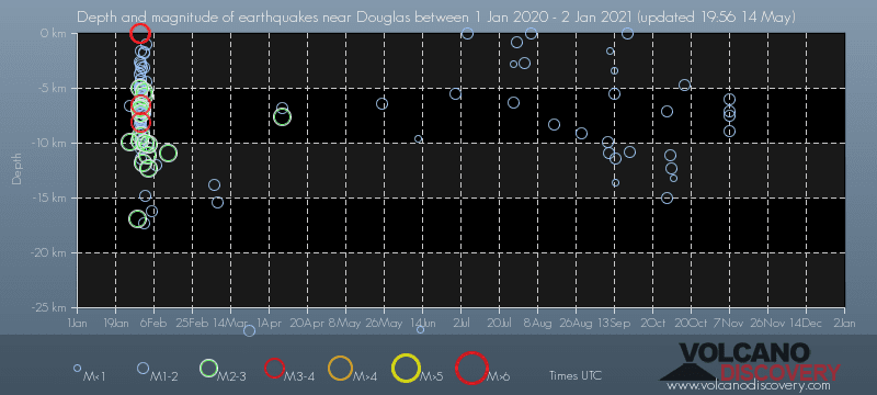
Contact | RSS | EN | DE | EL | ES | FR | IT | RU

Past earthquakes near Douglas volcano: 2020 - list, stats and map

Updated: Apr 25, 2024 04:42 GMT -
In 2020, Douglas volcano has had 159 quakes of magnitudes up to 3.4:
  • 5 quakes above magnitude 3
  • 37 quakes between magnitude 2 and 3
  • 117 quakes below magnitude 2 that people normally don't feel.
Strongest: Mag. 3.4 Earthquake 84 km SE of Kokhanok, Alaska -
[smaller] [bigger]

Quakes, magnitude and depth over time

Earthquake depth plot
Depth and magnitude of quakes over time
Filter by magnitude:
all
2.0+
3.0+
Showing quakes magnitude 0.5 or higher, within up to 30 km (19 mi) distance (165 quakes):
Past earthquakes near Douglas volcano: 2020 - list, stats and map
Date and TimeMag
Depth
DistanceLocationDetailsMap
Dec 26, 2020 04:08 am (Anchorage)
1.8

68 km
28 km (18 mi) to the N 78 Km SE of Pope-Vannoy Landing, Alaska, USA
Info
Thursday, December 24, 2020 GMT (1 quake)
Dec 24, 2020 07:20 am (Anchorage)
1.8

67 km
16 km (10 mi) to the E 93 Km SW of Nanwalek, Alaska, USA
Info
Tuesday, November 24, 2020 GMT (1 quake)
Nov 23, 2020 10:02 pm (Anchorage)
1.9

101 km
20 km (13 mi) to the N 76 km SE of Pope-Vannoy Landing, Alaska
Info
Saturday, November 7, 2020 GMT (4 quakes)
Nov 7, 2020 11:31 am (Anchorage)
1.6

8.9 km
15 km (9.6 mi) to the E 61 miles SW of Nanwalek, Alaska
Info
Nov 7, 2020 10:41 am (Anchorage)
1.4

6 km
9.2 km (5.7 mi) to the SE 55 miles NNW of Aleneva, Alaska
Info
Nov 7, 2020 10:24 am (Anchorage)
1.8

7.1 km
9 km (5.6 mi) to the E 56 miles NNW of Aleneva, Alaska
Info
Nov 7, 2020 09:41 am (Anchorage)
1.4

7.5 km
5.5 km (3.4 mi) to the SW 94 km NNW of Aleneva, Alaska
Info
Friday, November 6, 2020 GMT (2 quakes)
Nov 6, 2020 11:06 am (GMT +0)
2.5

69 km
27 km (17 mi) to the NE 81 km WSW of Nanwalek, Alaska
Info
Nov 6, 2020 11:06 am (GMT +0)
2.6

71 km
27 km (17 mi) to the NE 60 miles WSW of Seldovia
Info
Monday, November 2, 2020 GMT (1 quake)
Nov 2, 2020 02:01 pm (Anchorage)
2.1

73 km
24 km (15 mi) to the E 56 miles SW of Nanwalek, Alaska
Info
Friday, October 30, 2020 GMT (1 quake)
Oct 30, 2020 08:59 am (Anchorage)
1.9

75 km
8.1 km (5 mi) to the N 90 km SE of Pope-Vannoy Landing, Alaska
Info
Show more
About these data
Estimated combined seismic energy released: 3.7 x 10¹⁰ joules (10.4 megawatt hours, equivalent to 8.94 tons of TNT) | about seismic energy

Earthquake Catalog - Look up past earthquakes

Look up past earthquakes in this area by date or date range:
or
Look up quakes!
Felt a quake? Report it!
Show quakes near me!

Earthquake statistics

Number of earthquakes over time

in 2020
Number of earthquakes over time: in 2020

Magnitude and seismic energy over time

in 2020
Magnitude and seismic energy over time: in 2020

Magnitude and energy distribution

in 2020
Magnitude and energy distribution: in 2020

Embed or share standalone map

You can use the standalone version of our interactive earthquake map or embed it on your website:
Wed, 10 Apr 2013, 06:04

Douglas volcano (United States, Alaska Peninsula) activity update

Map of recent quakes at Douglas volcano in Alaska
A series of earthquakes up to magnitude 2.6 has occurred in the past 24 hours beneath the eastern flank of the volcano at depths around 20 km. ... Read all
Wed, 9 Jan 2013, 09:16

Douglas volcano (United States, Alaska Peninsula) activity update

Several shallow magnitude 2+ earthquakes occurred over the past 1-2 days under Douglas and Fourpeaked volcanoes. You can check current earthquake activity at www.volcanodiscovery.com/douglas-earthquakes.html and www.volcanodiscovery.com/fourpeaked-earthquakes.html. ... Read all
Try our free app!
Volcanoes & Earthquakes - new app for Android
Android | iOS version

More on VolcanoDiscovery

Why is there advertising on this site?

Support us - Help us upgrade our services!

We truly love working to bring you the latest volcano and earthquake data from around the world. Maintaining our website and our free apps does require, however, considerable time and resources.
We need financing to increase hard- and software capacity as well as support our editor team. We're aiming to achieve uninterrupted service wherever an earthquake or volcano eruption unfolds, and your donations can make it happen! Every donation will be highly appreciated. If you find the information useful and would like to support our team in integrating further features, write great content, and in upgrading our soft- and hardware, please make a donation (PayPal or Online credit card payment).

Planned features:Thanks to your past donations, these features have been added recently:
Download and Upgrade the Volcanoes & Earthquakes app to get one of the fastest seismic and volcano alerts online:
Android | IOS
Thank you!
Sources: VolcanoDiscovery / VolcanoAdventures and other sources as noted.
Use of material: Most text and images on our websites are owned by us. Re-use is generally not permitted without authorization. Contact us for licensing rights.
Volcanoes & Earthquakes
VolcanoDiscovery Home
Volcanoes | Earthquakes | Photos | Volcano News | App
Adventure & Study Travel
Tours to Volcanoes and Volcanic Areas: walking tours, photo tours, study tours
Tours & Dates | FAQ | About us
Get our newsletter!
Company info
Contact | Legal info | Terms & conditions
Follow us
Follow us on facebook Follow us on Instagram Follow us on Twitter Visit our Youtube channel
EN | DE | EL | ES | FR | IT | RU
VolcanoDiscovery GmbH, Germany, Reg. nr.: HRB 103744, EU Tax Id: DE 297 465 123 owned and created by
Dr. Tom Pfeiffer, volcanologist, volcano photographer, tour organizer member of
IAVCEI
IAVCEI
Vulkanologische Gesellschaft
Volcanological Society
Ecotourism Greece
Ecotourism Greece
RUV insurance
Insured by R+V
VolcanoDiscovery © 2004- All Rights Reserved | Privacy - Cookie Settings