Volcano earthquake report for Wednesday, 14 Oct 2020
Wed, 14 Oct 2020, 23:50 | BY: EARTHQUAKEMONITOR
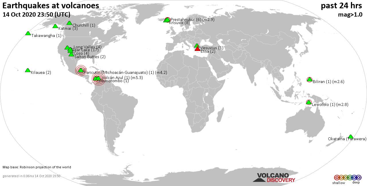
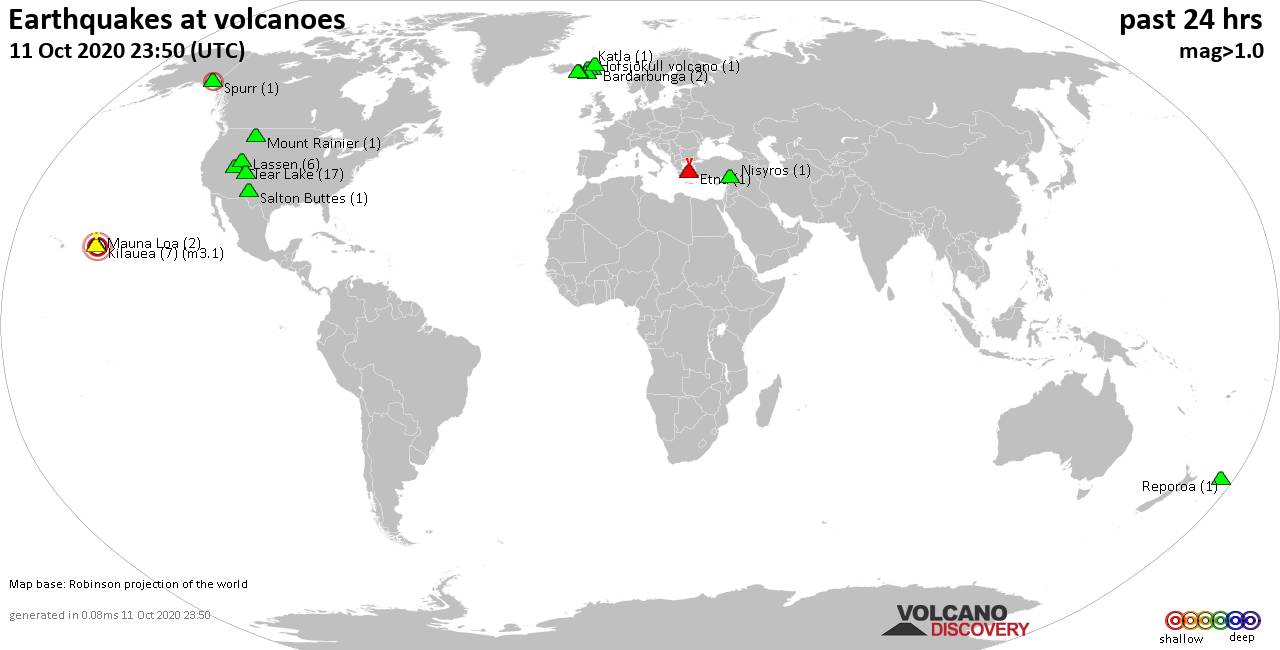
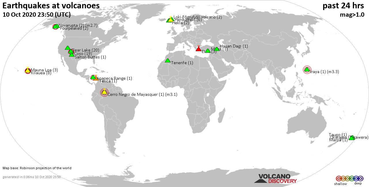
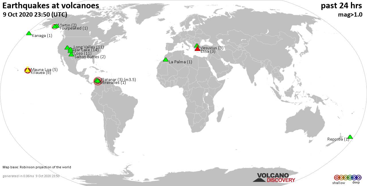
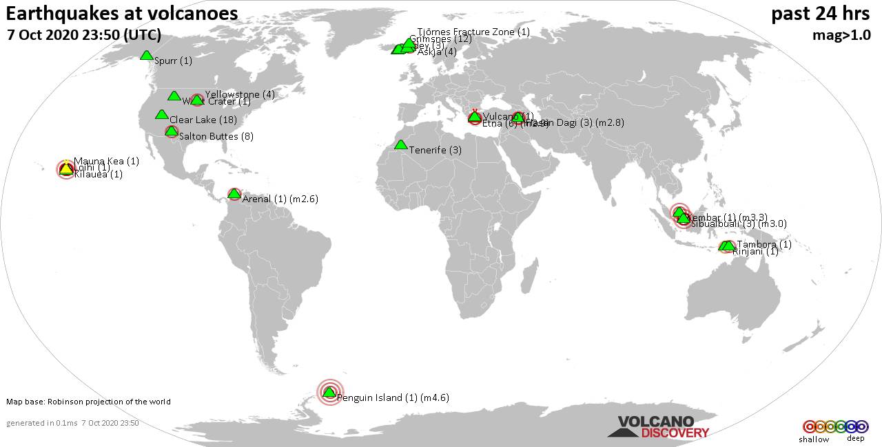
World map showing volcanoes with shallow (less than 20 km) earthquakes within 20 km radius during the past 24 hours on 14 Oct 2020 Number in brackets indicate nr of quakes.
Kilauea (2 quakes between mag 1.7-1.9), Krísuvík (8 quakes between mag 0.2-1.9), Lewotolo (1 quake mag 2.8), Long Valley (4 quakes between mag 0.3-1.1), Mammoth Mountain (4 quakes between mag 0.2-1.0), Momotombo (1 quake mag 2.5), Okataina (Tarawera) (1 quake mag 1.6), Paricutín (Michoacán-Guanajuato) (1 quake mag 4.2), Prestahnukur (6 quakes between mag 0.8-2.9), Salton Buttes (2 quakes between mag 1.4-1.5), Takawangha (1 quake mag 1.0), Vesuvius (1 quake mag 1.0), Volcán Azul (1 quake mag 5.3) (updated 23h50)
Note: Earthquakes within 20 km from and at depths less than 20 km under active volcanoes are reported. The list is not complete because many volcanoes are not monitored and/or seismic data in high resolution is not available publicly.
Volcanoes with recent earthquakes above magnitude 2 or more than 10 quakes are listed below:
Biliran volcano (Central Philippines): magnitude 2.6 earthquake
A magnitude 2.6 earthquake occurred at the volcano 14 hours ago. The quake, which might be volcanic in origin, was located at a depth of 5.0 km depth at 11 km distance SSW from the volcano.Earthquake details:
2.6 quake: 005 Km S 41° E of Biliran (Biliran), Philippines, 14 Oct 2020 09:48 (11 km SSW)
All earthquakes at Biliran
Clear Lake volcano (California): 17 earthquakes up to magnitude 1.8
Possible earthquake swarm: 17 earthquakes occurred near (under) the volcano during 21 hours, the last being recorded quake 47 minutes ago. Hypocenter depths ranged between 3.0 and 0.4 km.Earthquake details: (only 5 largest)
1.8 quake: 8km NW of The Geysers, CA, USA, 14 Oct 2020 03:21 (16 km SSW)
1.3 quake: 8km NW of The Geysers, CA, USA, 14 Oct 2020 03:23 (16 km SSW)
1.1 quake: 7km NW of The Geysers, CA, USA, 14 Oct 2020 16:12 (18 km SSW)
1.0 quake: 6km WNW of The Geysers, CA, USA, 14 Oct 2020 21:11 (19 km SSW)
0.8 quake: 6km WNW of The Geysers, CA, USA, 14 Oct 2020 19:47 (19 km SSW)
All earthquakes at Clear Lake
Lewotolo volcano (Lesser Sunda Islands): magnitude 2.8 earthquake
A magnitude 2.8 earthquake occurred at the volcano 19 hours ago. The quake, which might be volcanic in origin, was located at a depth of 10.0 km depth at 13 km distance NNE from the volcano.Earthquake details:
2.8 quake: Flores Region, Indonesia, 14 Oct 2020 04:33 (13 km NNE)
All earthquakes at Lewotolo
Momotombo volcano (Nicaragua): magnitude 2.5 earthquake
A magnitude 2.5 earthquake occurred at the volcano 3 hours ago. The quake, which might be volcanic in origin, was located at a depth of 8.0 km depth at 14 km distance SE from the volcano.Earthquake details:
2.5 quake: 10 Km Al Norte De Mateare, Nicaragua, 14 Oct 2020 20:51 (14 km SE)
All earthquakes at Momotombo
Paricutín (Michoacán-Guanajuato) volcano (Western & Central Mexico): magnitude 4.2 earthquake
A magnitude 4.2 earthquake occurred at the volcano 18 hours ago. The quake, which might be volcanic in origin, was located at a depth of 5.0 km depth at 19 km distance WNW from the volcano.Earthquake details:
4.2 quake: 7 Km Al NORTE De PERIBAN, MICH, Mexico, 14 Oct 2020 05:20 (19 km WNW)
All earthquakes at Paricutín (Michoacán-Guanajuato)
Prestahnukur volcano (Iceland): 6 earthquakes up to magnitude 2.9
6 earthquakes occurred near (under) the volcano during 10 hours, the last being recorded quake 2 hours ago. Hypocenter depths ranged between 10.5 and 2.0 km.Earthquake details: (only 5 largest)
2.9 quake: 16.0 Km ESE of Húsafell, Iceland, 14 Oct 2020 11:30 (2 km NNW)
2.2 quake: 15.4 Km SE of Húsafell, Iceland, 14 Oct 2020 11:30 (2 km WNW)
1.6 quake: 16.0 Km SE of Húsafell, Iceland, 14 Oct 2020 13:11 (2 km WNW)
1.3 quake: 16.1 Km SE of Húsafell, Iceland, 14 Oct 2020 21:33 (2 km W)
1.0 quake: 16.3 Km ESE of Húsafell, Iceland, 14 Oct 2020 14:54 (2 km NNW)
All earthquakes at Prestahnukur
Volcán Azul volcano (Nicaragua): magnitude 5.3 earthquake
A magnitude 5.3 earthquake occurred at the volcano 14 hours ago. The quake, which might be volcanic in origin, was located at a depth of 10.0 km depth at 17 km distance E from the volcano.Earthquake details:
5.3 quake: 22 Km Al Norte De Laguna De Perlas, Nicaragua, 14 Oct 2020 10:16 (17 km E)
All earthquakes at Volcán Azul
Previous news
Tue, 13 Oct 2020, 23:50
Volcano earthquake report for Tuesday, 13 Oct 2020
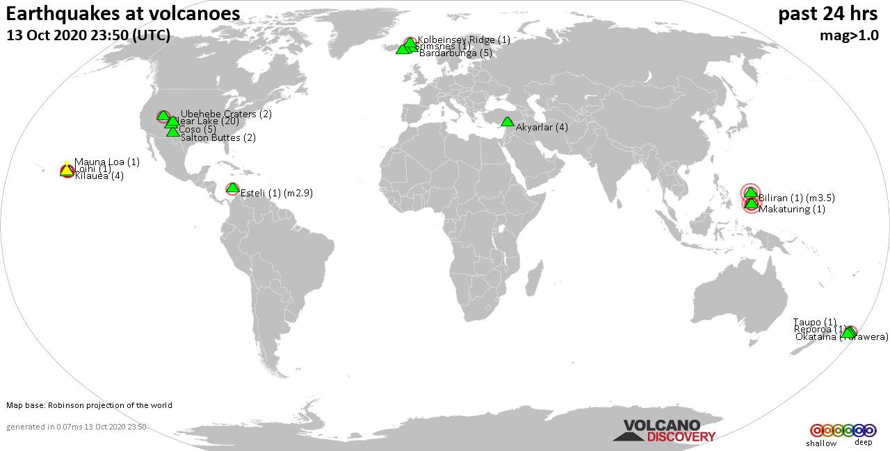
Quakes detected near: Akyarlar (4 quakes between mag 1.2-1.9), Bardarbunga (5 quakes between mag 0.2-1.6), Biliran (1 quake mag 3.5), Clear Lake (20 quakes between mag 0.3-2.3), Coso (5 quakes between mag 0.9-1.5), Esteli (1 quake mag 2.9) ... Read all
Mon, 12 Oct 2020, 23:50
Volcano earthquake report for Monday, 12 Oct 2020

Quakes detected near: Bardarbunga (1 quake mag 1.3), Buzzard Creek (1 quake mag 2.5), Clear Lake (15 quakes between mag 0.3-1.4), Coso (6 quakes between mag 0.5-1.8), Etna (5 quakes between mag 1.2-1.6), Ghegam (1 quake mag 2.5) ... Read all
Show more