Volcano earthquake report for Wednesday, 4 Nov 2020
Wed, 4 Nov 2020, 23:50 | BY: EARTHQUAKEMONITOR
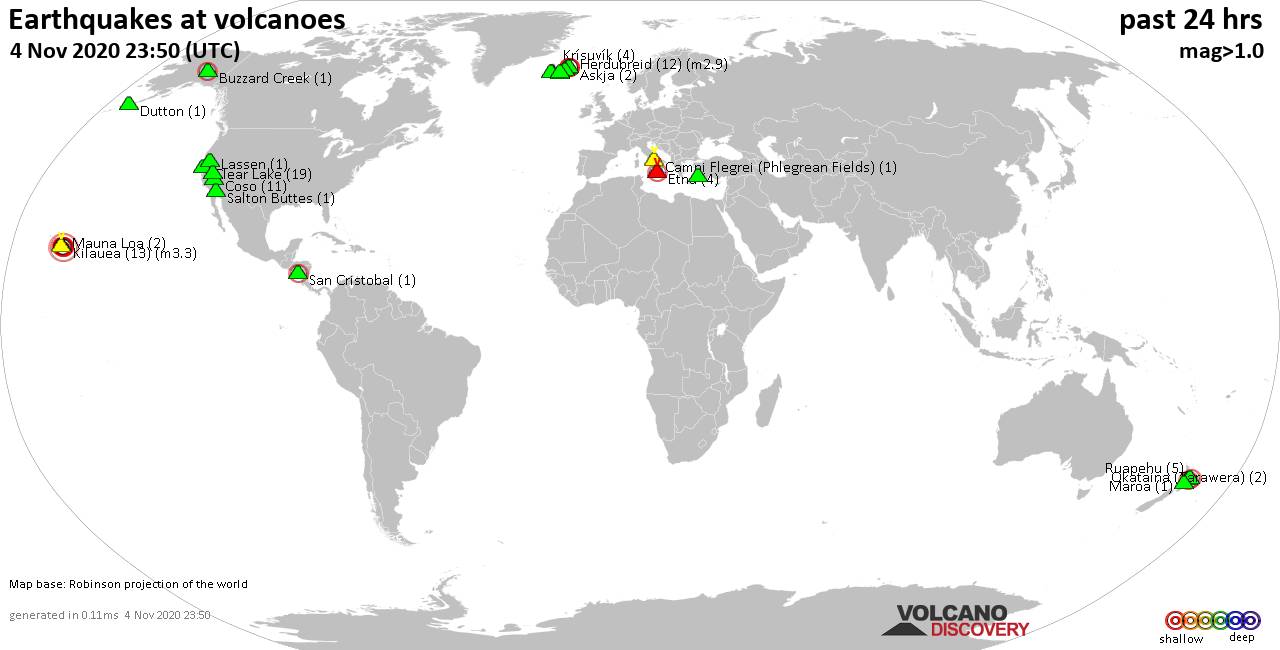
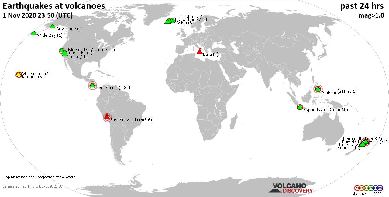
World map showing volcanoes with shallow (less than 20 km) earthquakes within 20 km radius during the past 24 hours on 4 Nov 2020 Number in brackets indicate nr of quakes.
Dutton (1 quake mag 1.4), Etna (4 quakes between mag 1.2-2.0), Herdubreid (12 quakes between mag 0.4-2.9), Katla (1 quake mag 1.1), Kilauea (13 quakes between mag 1.0-3.3), Krísuvík (4 quakes between mag 0.1-1.2), Lassen (1 quake mag 1.0), Loki-Fögrufjöll volcano (2 quakes between mag 0.4-1.1), Long Valley (3 quakes between mag 0.5-1.1), Maroa (1 quake mag 2.1), Mauna Loa (2 quakes between mag 0.8-2.1), Okataina (Tarawera) (2 quakes between mag 1.9-2.1), Reykjanes (9 quakes between mag 0.3-1.6), Ruapehu (5 quakes between mag 1.0-1.5), Salton Buttes (1 quake mag 1.3), San Cristobal (1 quake mag 2.1), Torfajökull (3 quakes between mag 0.6-1.4) (updated 23h50)
Note: Earthquakes within 20 km from and at depths less than 20 km under active volcanoes are reported. The list is not complete because many volcanoes are not monitored and/or seismic data in high resolution is not available publicly.
Volcanoes with recent earthquakes above magnitude 2 or more than 10 quakes are listed below:
Clear Lake volcano (California): 19 earthquakes up to magnitude 1.7
Possible earthquake swarm: 19 earthquakes occurred near (under) the volcano during 21 hours, the last being recorded quake 2 hours ago. Hypocenter depths ranged between 13.3 and 0.1 km.Earthquake details: (only 5 largest)
1.7 quake 15 miles SW of Clearlake, California, 4 Nov 2.06 am (GMT -8) (18 km SSW)
1.6 quake 15 miles SW of Clearlake, California, 4 Nov 11.05 am (GMT -8) (18 km SSW)
1.1 quake 15 miles SW of Clearlake, California, 4 Nov 9.35 am (GMT -8) (18 km SSW)
1.0 quake 13 miles SW of Clearlake, California, 3 Nov 8.31 pm (GMT -8) (16 km SSW)
0.9 quake 14 miles SW of Clearlake, California, 4 Nov 1.46 pm (GMT -8) (17 km SSW)
All earthquakes at Clear Lake
Coso volcano (California): 11 earthquakes up to magnitude 1.5
Possible earthquake swarm: 11 earthquakes occurred near (under) the volcano during 20 hours, the last being recorded quake 52 minutes ago. Hypocenter depths ranged between 8.8 and 1.0 km.Earthquake details: (only 5 largest)
1.5 quake 31 miles NNW of Ridgecrest, California, 4 Nov 10.24 am (GMT -8) (2 km NW)
1.4 quake 14 miles SE of Olancha, California, 4 Nov 4.33 am (GMT -8) (11 km NNW)
1.2 quake 21 miles N of Ridgecrest, California, 3 Nov 6.49 pm (GMT -8) (18 km SE)
1.1 quake 30 miles NNW of Ridgecrest, California, 4 Nov 2.58 pm (GMT -8) (7 km WSW)
1.1 quake 24 miles N of Ridgecrest, California, 4 Nov 3.28 am (GMT -8) (14 km ESE)
All earthquakes at Coso
Herdubreid volcano (Iceland): 12 earthquakes up to magnitude 2.9
Possible earthquake swarm: 12 earthquakes occurred near (under) the volcano during 11 hours, the last being recorded quake 12 hours ago. Hypocenter depths ranged between 7.4 and 1.6 km.Earthquake details: (only 5 largest)
2.9 quake 3.1 km NE of Herðubreið, Iceland, 2020-11-04 05:10 UTC (3 km ENE)
2.5 quake 3.1 km W of Herðubreiðarlindir, Iceland, 4 Nov 5.10 am (GMT +0) (3 km ENE)
2.2 quake 3.0 km NE of Herðubreið, Iceland, 2020-11-04 05:20 UTC (3 km ENE)
1.6 quake 2.8 km W of Herðubreiðarlindir, Iceland, 4 Nov 5.20 am (GMT +0) (3 km ENE)
1.3 quake 2.3 km NE of Herðubreið, Iceland, 4 Nov 1.06 am (GMT +0) (2 km ENE)
All earthquakes at Herdubreid
Kilauea volcano (Hawai'i (Big Island)): 13 earthquakes up to magnitude 3.3
Possible earthquake swarm: 13 earthquakes occurred near (under) the volcano during 21 hours, the last being recorded quake 2 hours ago. Hypocenter depths ranged between 6.9 and 0.2 km.Earthquake details: (only 5 largest)
3.3 quake 13 miles S of Mountain View, Hawaii, 4 Nov 11.33 am (GMT -10) (16 km ESE)
2.2 quake 15 miles S of Mountain View, Hawaii, 4 Nov 7.14 am (GMT -10) (18 km ESE)
2.1 quake 13 miles SW of Mountain View, Hawaii, 4 Nov 7.14 am (GMT -10) (4 km NE)
2.0 quake 15 miles SW of Mountain View, Hawaii, 4 Nov 5.18 am (GMT -10) (3 km ESE)
2.0 quake 15 miles SW of Mountain View, Hawaii, 4 Nov 5.17 am (GMT -10) (1 km ESE)
All earthquakes at Kilauea
Maroa volcano (New Zealand): magnitude 2.1 earthquake
A magnitude 2.1 earthquake occurred at the volcano 1 hour 33 minutes ago. The quake, which might be volcanic in origin, was located at a depth of 5.7 km depth at 19 km distance S from the volcano.Earthquake details:
2.1 quake 12 km NNW of Taupo, New Zealand, 5 Nov 11.16 am (GMT +13) (19 km S)
All earthquakes at Maroa
Mauna Loa volcano (Hawai'i (Big Island)): 2 earthquakes up to magnitude 2.1
2 earthquakes occurred near (under) the volcano during 7 hours, the last being recorded quake 13 hours ago. Hypocenter depths ranged between 3.8 and 2.0 km.Earthquake details:
2.1 quake 15 miles NW of Pāhala 4 Nov 12.40 am (GMT -10) (10 km S)
0.8 quake 14 miles ENE of Honaunau-Napoopoo, Hawaii, 3 Nov 5.54 pm (GMT -10) (10 km NW)
All earthquakes at Mauna Loa
Okataina (Tarawera) volcano (New Zealand): 2 earthquakes up to magnitude 2.1
2 earthquakes occurred near (under) the volcano during 1 hour 19 minutes, the last being recorded quake 8 hours ago. Hypocenter depths ranged between 5.2 and 5.0 km.Earthquake details:
2.1 quake 12 km SW of Kawerau, New Zealand, 5 Nov 3.40 am (GMT +13) (9 km ESE)
1.9 quake 12 km SW of Kawerau, New Zealand, 5 Nov 5.00 am (GMT +13) (11 km ESE)
All earthquakes at Okataina (Tarawera)
San Cristobal volcano (Nicaragua): magnitude 2.1 earthquake
A magnitude 2.1 earthquake occurred at the volcano 7 hours ago. The quake, which might be volcanic in origin, was located at a depth of 8.0 km depth at 19 km distance ENE from the volcano.Earthquake details:
2.1 quake 40 km N of León, Nicaragua, 4 Nov 10.45 am (GMT -6) (19 km ENE)
All earthquakes at San Cristobal
Previous news
Tue, 3 Nov 2020, 23:50
Volcano earthquake report for Tuesday, 3 Nov 2020
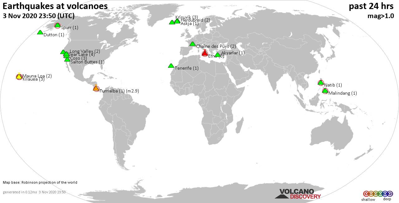
Quakes detected near: Akyarlar (1 quake mag 1.7), Askja (1 quake mag 1.1), Chaîne des Puys (2 quakes between mag 1.2-1.8), Clear Lake (4 quakes between mag 0.7-1.1), Coso (3 quakes between mag 0.5-1.4), Dutton (1 quake mag 1.2) ... Read all
Mon, 2 Nov 2020, 23:50
Volcano earthquake report for Monday, 2 Nov 2020
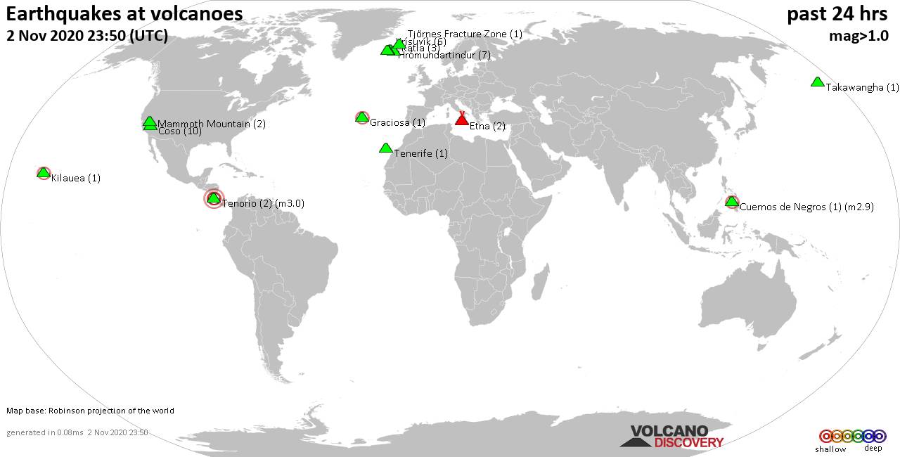
Quakes detected near: Coso (10 quakes between mag 0.4-1.5), Cuernos de Negros (1 quake mag 2.9), Etna (2 quakes between mag 1.1-1.2), Graciosa (1 quake mag 2.0), Hrómundartindur (7 quakes between mag 0.1-1.4), Katla (3 quakes between mag 0.4-1.2) ... Read all
Show more