Volcano earthquake report for Thursday, 12 Nov 2020
Thu, 12 Nov 2020, 23:50 | BY: EARTHQUAKEMONITOR
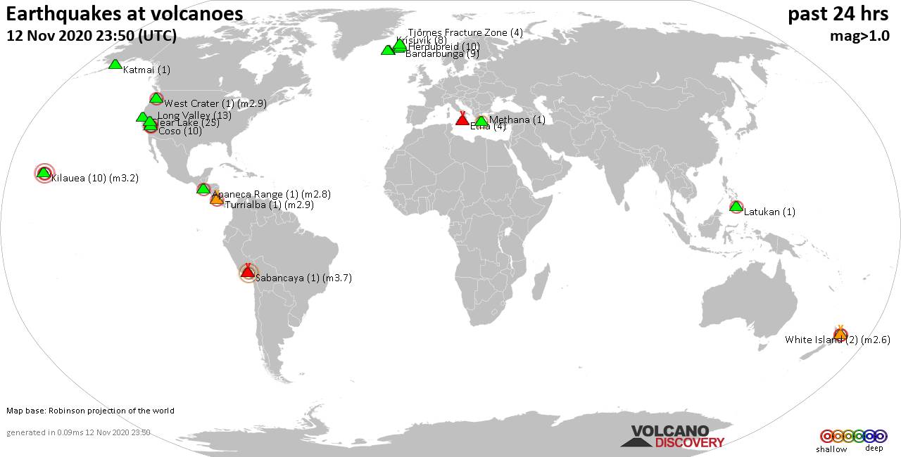
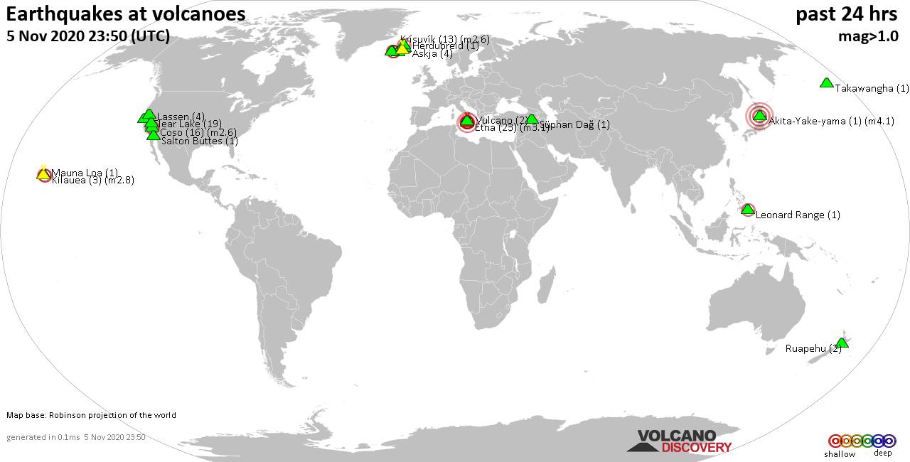
World map showing volcanoes with shallow (less than 20 km) earthquakes within 20 km radius during the past 24 hours on 12 Nov 2020 Number in brackets indicate nr of quakes.
Katmai (1 quake mag 1.3), Kilauea (10 quakes between mag 1.7-3.2), Krísuvík (8 quakes between mag 0.3-1.6), Latukan (1 quake mag 2.5), Long Valley (13 quakes between mag 0.3-1.5), Methana (1 quake mag 2.0), Reykjanes (25 quakes between mag 0.1-1.8), Sabancaya (1 quake mag 3.7), Tjörnes Fracture Zone (4 quakes between mag 1.3-1.6), Turrialba (1 quake mag 2.9), West Crater (1 quake mag 2.9), White Island (2 quakes between mag 2.5-2.6) (updated 23h50)
Note: Earthquakes within 20 km from and at depths less than 20 km under active volcanoes are reported. The list is not complete because many volcanoes are not monitored and/or seismic data in high resolution is not available publicly.
Volcanoes with recent earthquakes above magnitude 2 or more than 10 quakes are listed below:
Apaneca Range volcano (El Salvador): magnitude 2.8 earthquake
A magnitude 2.8 earthquake occurred at the volcano 18 hours ago. The quake, which might be volcanic in origin, was located at a depth of 4.0 km depth at 6 km distance E from the volcano.Earthquake details:
2.8 quake 22 km SW of Santa Ana, El Salvador, 2020-11-11 23:35:30 (6 km E)
All earthquakes at Apaneca Range
Clear Lake volcano (California): 25 earthquakes up to magnitude 1.9
Possible earthquake swarm: 25 earthquakes occurred near (under) the volcano during 17 hours, the last being recorded quake 7 hours ago. Hypocenter depths ranged between 6.0 and 0.6 km.Earthquake details: (only 5 largest)
1.9 quake 7.9 miles ENE of Cloverdale, California, 12 November 14:08 UTC (17 km SSW)
1.7 quake 13 miles SW of Clearlake, California, 12 November 04:44 UTC (16 km SSW)
1.6 quake 13 miles SSW of Clearlake, California, 12 November 05:17 UTC (19 km S)
1.5 quake 3.4 miles N of Clearlake, California, 12 November 05:29 UTC (13 km ENE)
1.2 quake 12 miles SSW of Clearlake, California, 12 November 14:06 UTC (18 km S)
All earthquakes at Clear Lake
Coso volcano (California): 10 earthquakes up to magnitude 2.1
10 earthquakes occurred near (under) the volcano during 22 hours, the last being recorded quake 23 minutes ago. Hypocenter depths ranged between 6.8 and 0.6 km.Earthquake details: (only 5 largest)
2.1 quake 15 miles SE of Olancha, California, 12 November 15:05 UTC (9 km NNW)
2.1 quake 25 miles N of Ridgecrest, California, 12 November 10:48 UTC (14 km ESE)
1.9 quake 15 miles SE of Olancha, California, 12 November 12:59 UTC (8 km NNW)
1.4 quake 25 miles N of Ridgecrest, California, 12 November 13:39 UTC (14 km ESE)
1.2 quake 23 miles N of Ridgecrest, California, 12 November 23:27 UTC (16 km ESE)
All earthquakes at Coso
Kilauea volcano (Hawai'i (Big Island)): 10 earthquakes up to magnitude 3.2
10 earthquakes occurred near (under) the volcano during 18 hours, the last being recorded quake 4 hours ago. Hypocenter depths ranged between 5.3 and 0.2 km.Earthquake details: (only 5 largest)
3.2 quake 15 miles SW of Mountain View 11 Nov 4.05 pm (GMT -10) (3 km ESE)
2.0 quake 15 miles SSW of Mountain View 12 November 02:43 UTC (13 km ESE)
1.9 quake 14 miles SW of Mountain View, Hawaii, 12 November 19:23 UTC (2 km ENE)
1.9 quake 15 miles SW of Mountain View, Hawaii, 12 November 18:26 UTC (1 km NNE)
1.9 quake 9.7 miles W of Volcano, Hawaii, 12 November 07:27 UTC (11 km WSW)
All earthquakes at Kilauea
Latukan volcano (Mindanao): magnitude 2.5 earthquake
A magnitude 2.5 earthquake occurred at the volcano 8 hours ago. The quake, which might be volcanic in origin, was located at a depth of 4.0 km depth at 6 km distance W from the volcano.Earthquake details:
2.5 quake 14 km SE of Butig, Philippines, 13 November 2020 - 12:01 AM (PST) (6 km W)
All earthquakes at Latukan
Long Valley volcano (California): 13 earthquakes up to magnitude 1.5
Possible earthquake swarm: 13 earthquakes occurred near (under) the volcano during 21 hours, the last being recorded quake 2 hours ago. Hypocenter depths ranged between 3.0 and 0.3 km.Earthquake details: (only 5 largest)
1.5 quake 6.7 miles E of Mammoth Lakes, California, 12 November 12:40 UTC (5 km SSE)
1.4 quake 6 miles E of Mammoth Lakes, California, 12 November 17:36 UTC (4 km S)
1.3 quake 6 miles E of Mammoth Lakes, California, 12 November 17:39 UTC (4 km S)
1.2 quake 6 miles E of Mammoth Lakes, California, 12 November 19:33 UTC (4 km S)
1.1 quake 5.9 miles E of Mammoth Lakes, California, 12 November 20:11 UTC (4 km S)
All earthquakes at Long Valley
Reykjanes volcano (Iceland): 25 earthquakes up to magnitude 1.8
Possible earthquake swarm: 25 earthquakes occurred near (under) the volcano during 18 hours, the last being recorded quake 6 hours ago. Hypocenter depths ranged between 6.2 and 0.1 km.Earthquake details: (only 5 largest)
1.8 quake 3.7 km NNW of Grindavík, Iceland, 12 November 11:15 UTC (4 km SE)
1.3 quake 3.3 km NE of Grindavík, Iceland, 12 November 02:46 UTC (7 km ESE)
1.0 quake 5.2 km WSW of Fagradalsfjall, Iceland, 12 November 13:12 UTC (7 km E)
1.0 quake 5.1 km WSW of Fagradalsfjall, Iceland, 12 November 10:51 UTC (7 km E)
0.9 quake 5.2 km WSW of Fagradalsfjall, Iceland, 12 November 18:12 UTC (7 km E)
All earthquakes at Reykjanes
Sabancaya volcano (Peru): magnitude 3.7 earthquake
A magnitude 3.7 earthquake occurred at the volcano 6 hours ago. The quake, which might be volcanic in origin, was located at a depth of 15.0 km depth at 14 km distance NE from the volcano.Earthquake details:
3.7 quake 17 km WSW of Chivay, Peru, 12/11/2020 12:55:50 (14 km NE)
All earthquakes at Sabancaya
Turrialba volcano (Costa Rica): magnitude 2.9 earthquake
A magnitude 2.9 earthquake occurred at the volcano 21 hours ago. The quake, which might be volcanic in origin, was located at a depth of 3.0 km depth at 1 km distance S from the volcano.Earthquake details:
2.9 quake 23 km NNE of Paraíso, Costa Rica, 11 de noviembre del 2020 9:06 pm (1 km S)
All earthquakes at Turrialba
West Crater volcano (Washington): magnitude 2.9 earthquake
A magnitude 2.9 earthquake occurred at the volcano 3 hours ago. The quake, which might be volcanic in origin, was located at a depth of 9.8 km depth at 9 km distance N from the volcano.Earthquake details:
2.9 quake 30 miles NNE of Camas, Washington, 12 Nov 12.49 pm (GMT -8) (9 km N)
All earthquakes at West Crater
White Island volcano (New Zealand): 2 earthquakes up to magnitude 2.6
2 earthquakes occurred near (under) the volcano during 3 hours, the last being recorded quake 6 hours ago. Hypocenter depths ranged between 5.0 and 5.0 km.Earthquake details:
2.6 quake 40 km NNE of Whakatane, New Zealand, 12 November 18:08 UTC (10 km SSW)
2.5 quake 42 km NNE of Whakatane, New Zealand, 12 November 15:04 UTC (10 km SSW)
All earthquakes at White Island
Previous news
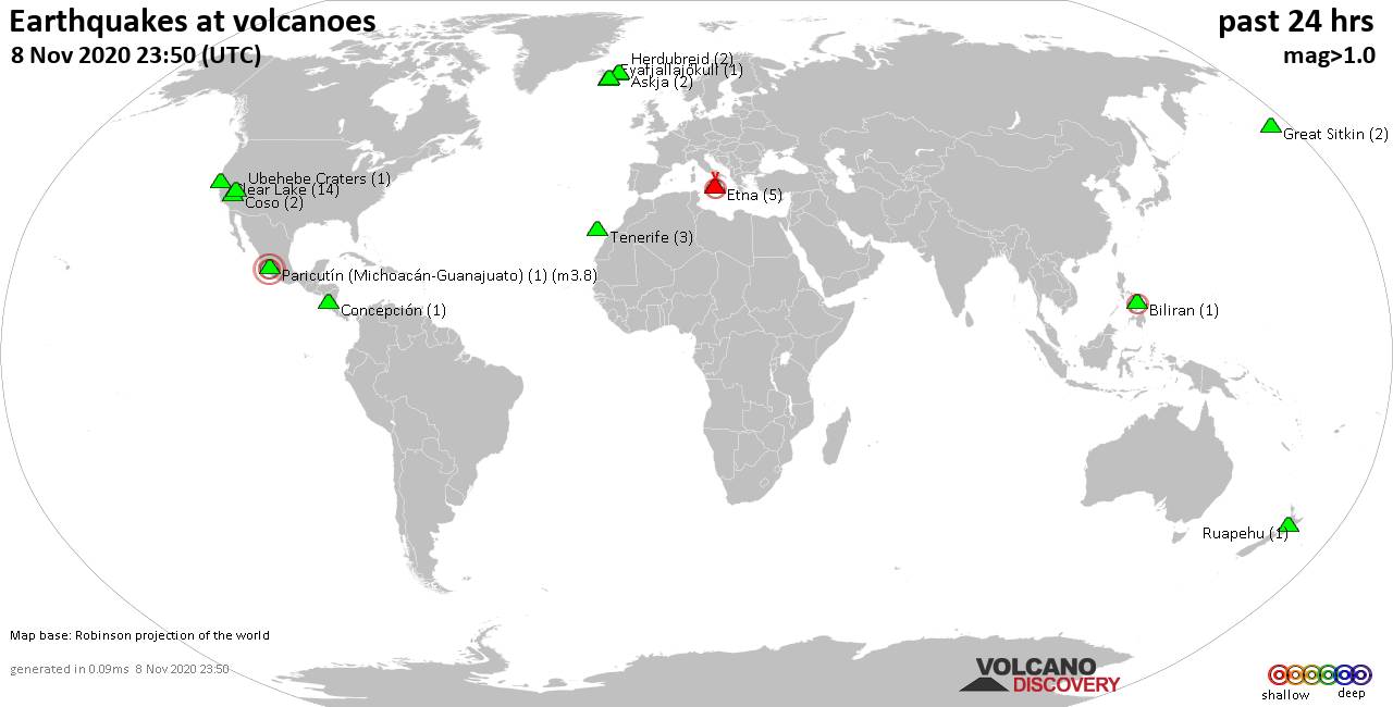
Wed, 11 Nov 2020, 23:50
Volcano earthquake report for Wednesday, 11 Nov 2020
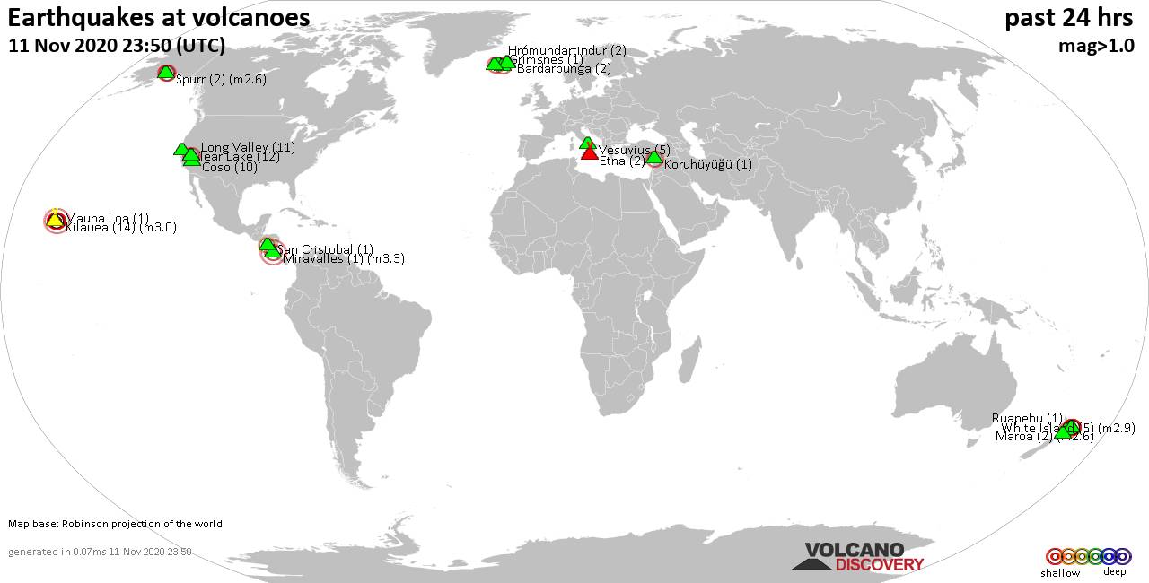
Quakes detected near: Bardarbunga (2 quakes between mag 0.4-1.4), Clear Lake (12 quakes between mag 0.2-1.9), Coso (10 quakes between mag 0.3-1.8), Etna (2 quakes between mag 1.3-1.8), Grímsnes (1 quake mag 1.0), Hrómundartindur (2 quakes between mag 0.7-1.1) ... Read all
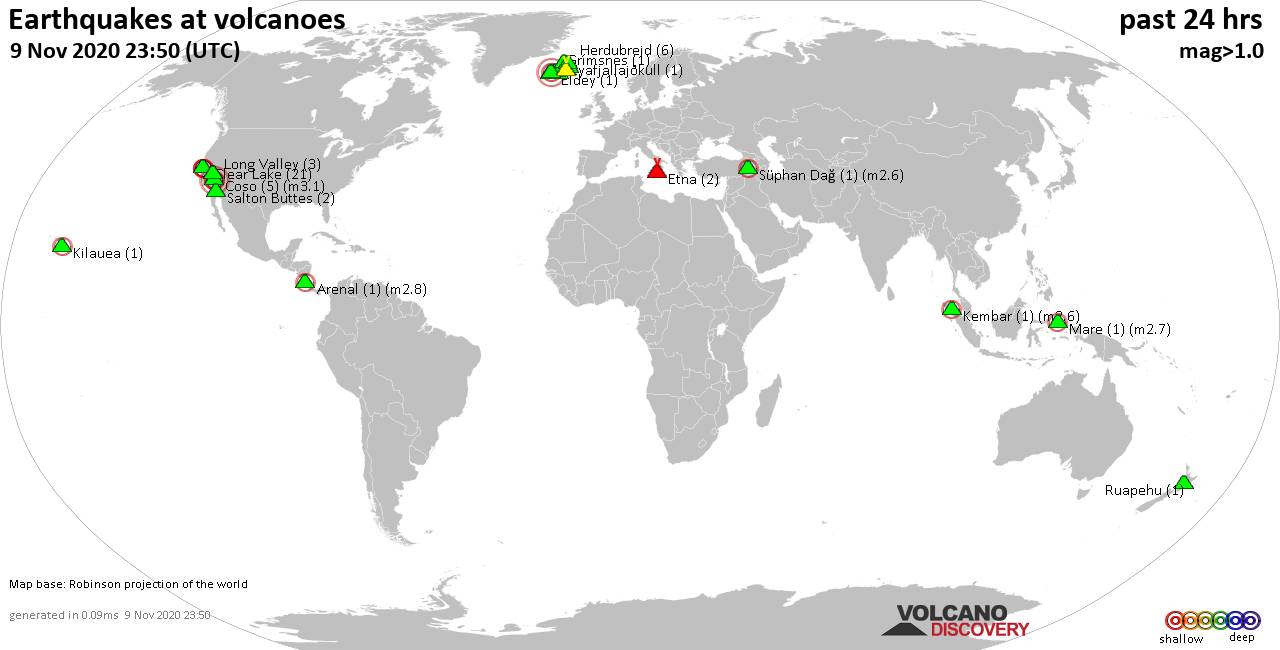
Tue, 10 Nov 2020, 23:50
Volcano earthquake report for Tuesday, 10 Nov 2020
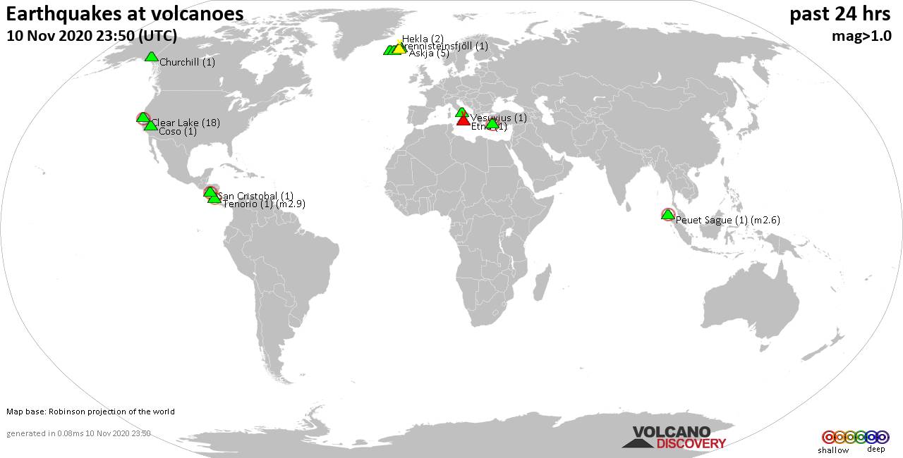
Quakes detected near: Akyarlar (1 quake mag 2.5), Askja (5 quakes between mag 0.1-1.8), Brennisteinsfjöll (1 quake mag 1.4), Churchill (1 quake mag 1.5), Clear Lake (18 quakes between mag 0.1-2.1), Coso (1 quake mag 1.2) ... Read all
Show more