Volcano earthquake report for Wednesday, 27 Jan 2021
Wed, 27 Jan 2021, 23:50 | BY: EARTHQUAKEMONITOR

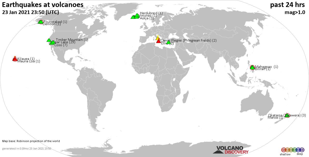
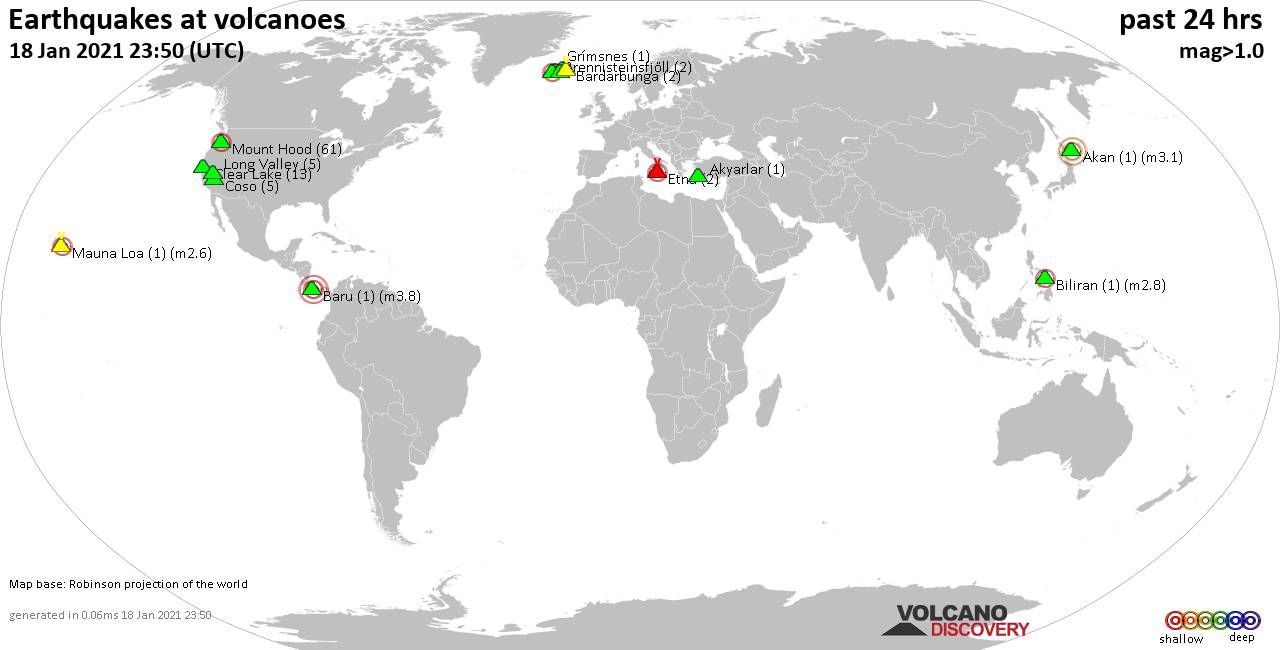
World map showing volcanoes with shallow (less than 20 km) earthquakes within 20 km radius during the past 24 hours on 27 Jan 2021 Number in brackets indicate nr of quakes.
Gunung Semuning (Ranau caldera) (1 quake mag 3.3), Hofsjökull volcano (1 quake mag 1.9), Hrómundartindur (1 quake mag 1.0), Kilauea (5 quakes between mag 0.6-2.6), Krísuvík (3 quakes between mag 0.8-1.7), Loki-Fögrufjöll volcano (2 quakes between mag 0.8-1.2), Long Valley (8 quakes between mag 0.5-1.9), Mauna Loa (1 quake mag 2.1), Okataina (Tarawera) (4 quakes between mag 1.3-1.7), Prestahnukur (37 quakes between mag 1.0-3.0), Reykjanes (15 quakes between mag 0.2-1.2), San Pablo (1 quake mag 2.9), Sharat Kovakab (1 quake mag 2.0), Süphan Dağ (1 quake mag 2.0), Takawangha (1 quake mag 1.3), Tjörnes Fracture Zone (4 quakes between mag 0.4-1.1), Toba (1 quake mag 2.3), Tongariro (1 quake mag 1.3) (updated 23h50)
Note: Earthquakes within 20 km from and at depths less than 20 km under active volcanoes are reported. The list is not complete because many volcanoes are not monitored and/or seismic data in high resolution is not available publicly.
Volcanoes with recent earthquakes above magnitude 2 or more than 10 quakes are listed below:
Clear Lake volcano (California): 8 earthquakes up to magnitude 2.2
8 earthquakes occurred near (under) the volcano during 19 hours, the last being recorded quake 3 hours ago. Hypocenter depths ranged between 2.0 and 1.0 km.Earthquake details: (only 5 largest)
2.2 quake 7km WNW of The Geysers, CA, USA, 27 Jan 2021 6:34 am (GMT -8) (19 km SSW)
1.7 quake 10km WNW of The Geysers, CA, USA, 27 Jan 2021 12:57 am (GMT -8) (18 km SSW)
1.7 quake 8km NW of The Geysers, CA, USA, 26 Jan 2021 10:58 pm (GMT -8) (16 km SSW)
1.5 quake 5km WNW of Cobb, CA, USA, 27 Jan 2021 12:41 pm (GMT -8) (15 km S)
1.4 quake 5km WNW of Cobb, CA, USA, 27 Jan 2021 11:16 am (GMT -8) (15 km S)
All earthquakes at Clear Lake
El Chichón volcano (Southern Mexico): magnitude 3.2 earthquake
A magnitude 3.2 earthquake occurred at the volcano 14 hours ago. The quake, which might be volcanic in origin, was located at a depth of 1.0 km depth at 6 km distance ESE from the volcano.Earthquake details:
3.2 quake Chapultenango, Chiapas, 34 km southwest of Teapa, Tabasco, Mexico, 2021-01-27 03:41:11 (6 km ESE)
All earthquakes at El Chichón
Eyafjallajökull volcano (Iceland): magnitude 2.1 earthquake
A magnitude 2.1 earthquake occurred at the volcano 11 hours ago. The quake, which might be volcanic in origin, was located at a depth of 4.9 km depth at 14 km distance ESE from the volcano.Earthquake details:
2.1 quake 6.7 Km NE of Skógar, Iceland, 27 Jan 2021 1:08 pm (GMT +0) (14 km ESE)
All earthquakes at Eyafjallajökull
Gunung Semuning (Ranau caldera) volcano (Sumatra): magnitude 3.3 earthquake
A magnitude 3.3 earthquake occurred at the volcano 5 hours ago. The quake, which might be volcanic in origin, was located at a depth of 10.0 km depth at 17 km distance SW from the volcano.Earthquake details:
3.3 quake Indian Ocean, 129 km west of Kotabumi, Lampung, Indonesia, 28 Jan 2021 1:36 am (GMT +7) (17 km SW)
All earthquakes at Gunung Semuning (Ranau caldera)
Kilauea volcano (Hawai'i (Big Island)): 5 earthquakes up to magnitude 2.6
5 earthquakes occurred near (under) the volcano during 12 hours, the last being recorded quake 7 hours ago. Hypocenter depths ranged between 5.4 and 0.1 km.Earthquake details:
2.6 quake 15 Km SSW of Volcano, Hawaii, USA, 26 Jan 2021 7:37 pm (GMT -10) (11 km SSE)
2.3 quake Island of Hawaii, Hawaii, USA, 27 Jan 2021 6:59 am (GMT -10) (17 km WNW)
2.0 quake 11 Km WSW of Volcano, Hawaii, USA, 26 Jan 2021 6:39 pm (GMT -10) (5 km WNW)
1.8 quake 19 Km W of Volcano, Hawaii, USA, 27 Jan 2021 1:49 am (GMT -10) (13 km W)
0.6 quake 7 Km SW of Volcano, Hawaii, USA, 26 Jan 2021 11:53 pm (GMT -10) (0 km WSW)
All earthquakes at Kilauea
Mauna Loa volcano (Hawai'i (Big Island)): magnitude 2.1 earthquake
A magnitude 2.1 earthquake occurred at the volcano 39 minutes ago. The quake, which might be volcanic in origin, was located at a depth of 1.5 km depth at 5 km distance NE from the volcano.Earthquake details:
2.1 quake 31 Km E of Honaunau-Napoopoo, Hawaii, USA, 27 Jan 2021 1:11 pm (GMT -10) (5 km NE)
All earthquakes at Mauna Loa
Prestahnukur volcano (Iceland): 37 earthquakes up to magnitude 3.0
Possible earthquake swarm: 37 earthquakes occurred near (under) the volcano during 9 hours, the last being recorded quake 5 hours ago. Hypocenter depths ranged between 17.8 and 1.2 km.Earthquake details: (only 5 largest)
3.0 quake 15.2 Km N of Skjaldbreið, Iceland, 27 Jan 2021 1:06 pm (GMT +0) (9 km SW)
2.7 quake 14.6 Km N of Skjaldbreið, Iceland, 27 Jan 2021 1:07 pm (GMT +0) (9 km SSW)
2.3 quake 13.1 Km N of Skjaldbreið, Iceland, 27 Jan 2021 4:05 pm (GMT +0) (12 km SW)
2.3 quake 12.4 Km N of Skjaldbreið, Iceland, 27 Jan 2021 2:16 pm (GMT +0) (12 km SW)
2.2 quake 14.8 Km N of Skjaldbreið, Iceland, 27 Jan 2021 1:14 pm (GMT +0) (10 km SSW)
All earthquakes at Prestahnukur
Reykjanes volcano (Iceland): 15 earthquakes up to magnitude 1.2
Possible earthquake swarm: 15 earthquakes occurred near (under) the volcano during 17 hours, the last being recorded quake 6 hours ago. Hypocenter depths ranged between 6.0 and 0.1 km.Earthquake details: (only 5 largest)
1.2 quake 4.0 Km SSW of Fagradalsfjall, Iceland, 27 January 2021 09:46 GMT (10 km ESE)
1.2 quake 4.8 Km WSW of Fagradalsfjall, Iceland, 27 January 2021 06:15 GMT (8 km E)
1.2 quake 5.1 Km WSW of Fagradalsfjall, Iceland, 27 January 2021 02:38 GMT (8 km E)
1.1 quake 4.7 Km WSW of Fagradalsfjall, Iceland, 27 January 2021 02:33 GMT (8 km E)
0.9 quake 3.0 Km SSW of Fagradalsfjall, Iceland, 27 January 2021 11:15 GMT (11 km E)
All earthquakes at Reykjanes
San Pablo volcano (Luzon Island): magnitude 2.9 earthquake
A magnitude 2.9 earthquake occurred at the volcano 5 hours ago. The quake, which might be volcanic in origin, was located at a depth of 6.0 km depth at 16 km distance NW from the volcano.Earthquake details:
2.9 quake 4.3 km northeast of Calamba, Province of Laguna, Calabarzon, Philippines, 28 Jan 2021 2:49 am (GMT +8) (16 km NW)
All earthquakes at San Pablo
Toba volcano (Sumatra): magnitude 2.3 earthquake
A magnitude 2.3 earthquake occurred at the volcano 6 hours ago. The quake, which might be volcanic in origin, was located at a depth of 10.0 km depth at 18 km distance WNW from the volcano.Earthquake details:
2.3 quake 83 km south of Kabanjahe, Sumatera Utara, Indonesia, 28 Jan 2021 1:09 am (GMT +7) (18 km WNW)
All earthquakes at Toba
Previous news
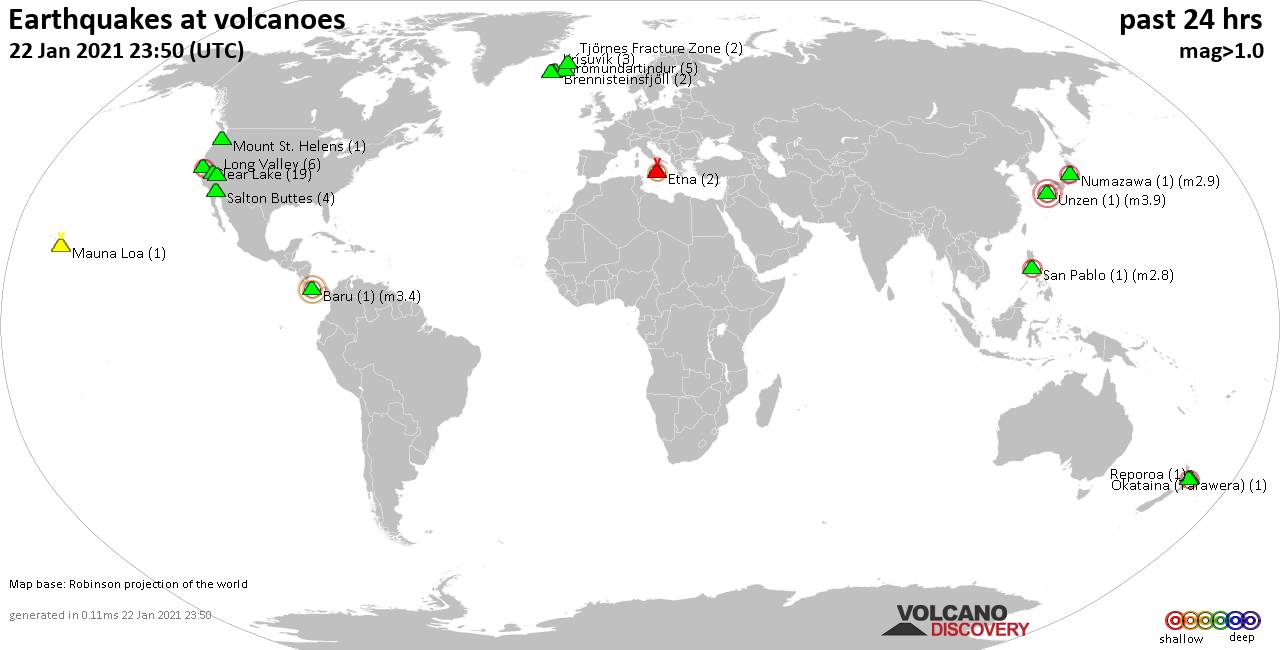
Tue, 26 Jan 2021, 23:50
Volcano earthquake report for Tuesday, 26 Jan 2021
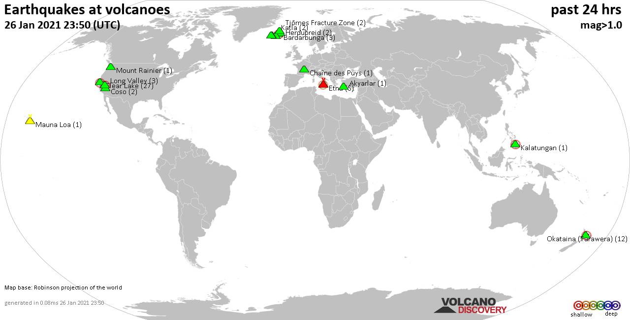
Quakes detected near: Akyarlar (1 quake mag 1.8), Bardarbunga (3 quakes between mag 0.3-2.1), Chaîne des Puys (1 quake mag 1.1), Clear Lake (27 quakes between mag 0.1-2.1), Coso (2 quakes between mag 0.9-1.5), Etna (5 quakes between mag 1.7-2.4) ... Read all
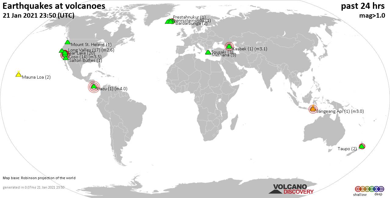
Mon, 25 Jan 2021, 23:50
Volcano earthquake report for Monday, 25 Jan 2021
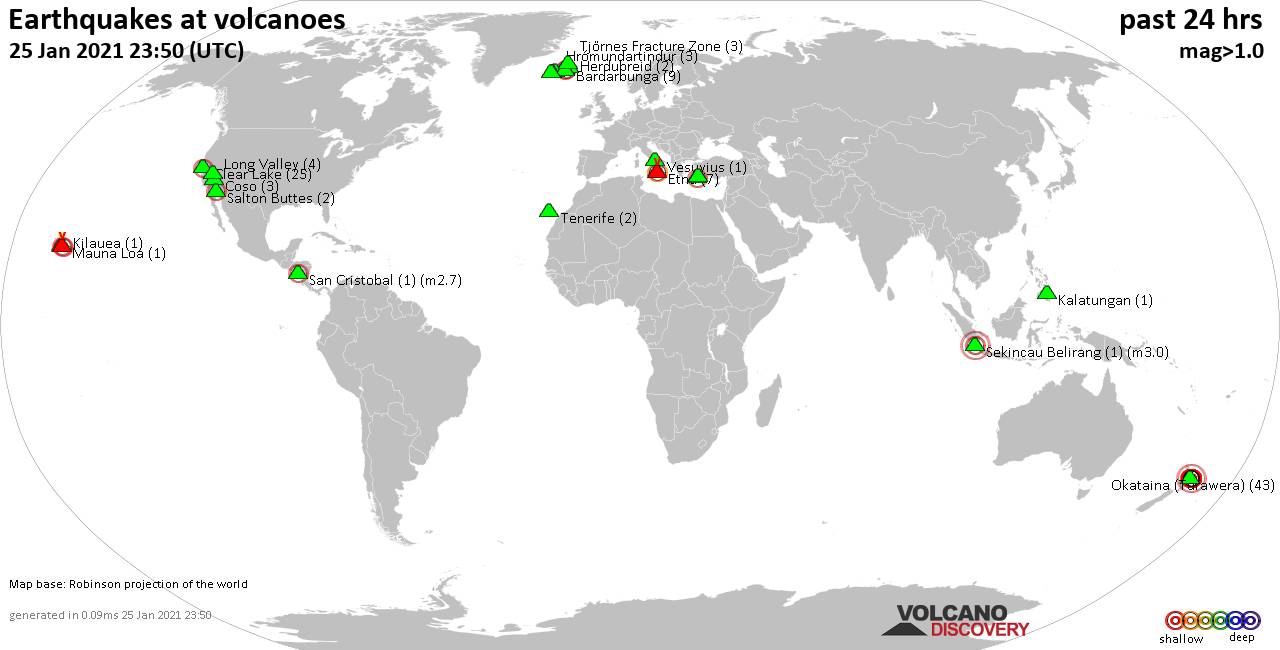
Quakes detected near: Akyarlar (1 quake mag 1.2), Bardarbunga (9 quakes between mag 0.1-2.2), Clear Lake (25 quakes between mag 0.3-2.3), Coso (3 quakes between mag 0.9-1.4), Etna (7 quakes between mag 1.5-2.2), Herdubreid (2 quakes between mag 1.0-1.3) ... Read all
Show more