Volcano earthquake report for Saturday, 6 Mar 2021
Sat, 6 Mar 2021, 23:50 | BY: EARTHQUAKEMONITOR
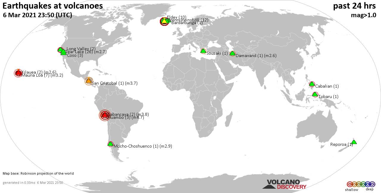
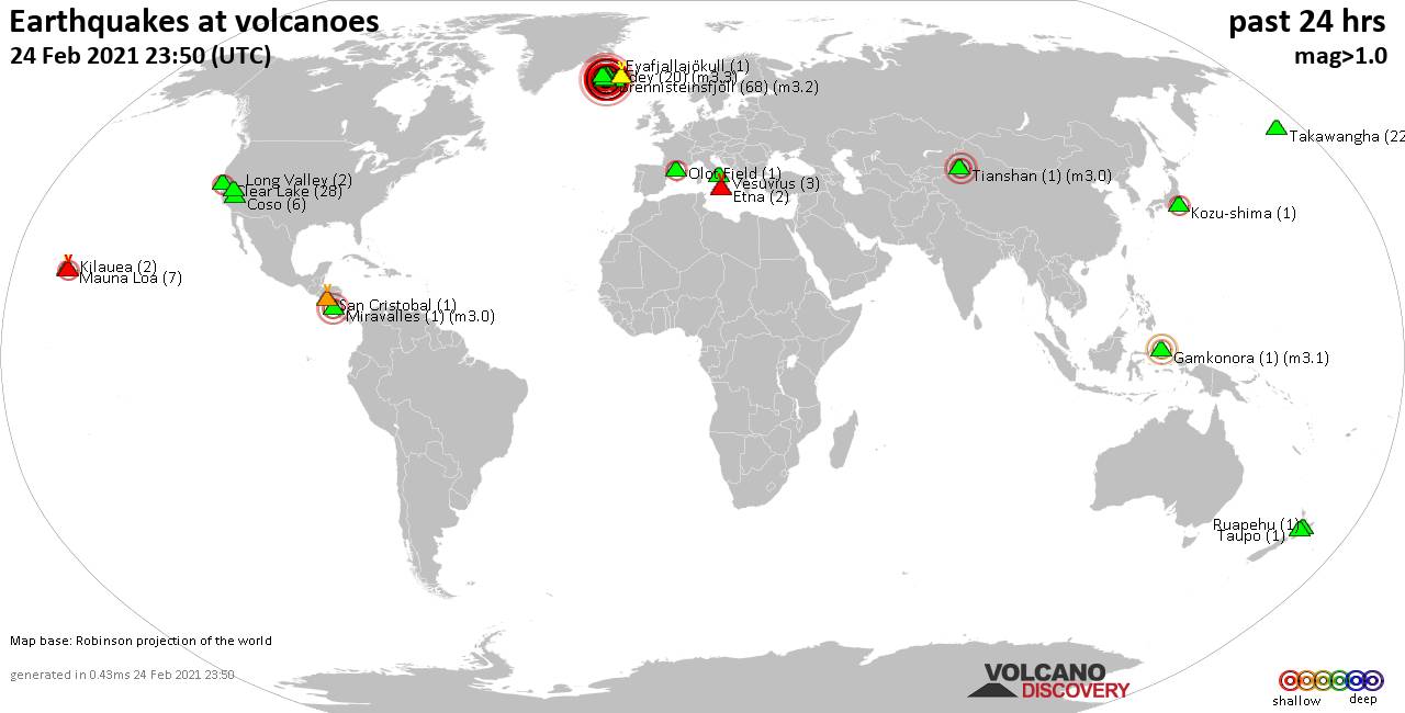
World map showing volcanoes with shallow (less than 20 km) earthquakes within 20 km radius during the past 24 hours on 6 Mar 2021 Number in brackets indicate nr of quakes.
Eldey (10 quakes between mag 0.3-1.4), Grímsnes (3 quakes between mag 0.5-1.9), Huambo (3 quakes between mag 3.6-4.7), Kilauea (2 quakes between mag 2.1-2.6), Krísuvík (1130 quakes between mag 0.1-3.9), Ljósufjöll (1 quake mag 2.6), Long Valley (2 quakes between mag 0.9-1.1), Mauna Loa (7 quakes between mag 1.7-3.2), Mocho-Choshuenco (1 quake mag 2.9), Reporoa (1 quake mag 1.5), Reykjanes (244 quakes between mag 0.1-3.5), Sabancaya (2 quakes between mag 3.6-3.8), San Cristobal (1 quake mag 3.7), Snaefellsjökull (1 quake mag 1.5), Sousaki (1 quake mag 2.2), Tindfjallajökull (1 quake mag 1.2), Tobaru (1 quake mag 2.0) (updated 23h50)
Note: Earthquakes within 20 km from and at depths less than 20 km under active volcanoes are reported. The list is not complete because many volcanoes are not monitored and/or seismic data in high resolution is not available publicly.
Volcanoes with recent earthquakes above magnitude 2 or more than 10 quakes are listed below:
Brennisteinsfjöll volcano (Iceland): 12 earthquakes up to magnitude 1.4
Possible earthquake swarm: 12 earthquakes occurred near (under) the volcano during 21 hours, the last being recorded quake 2 hours ago. Hypocenter depths ranged between 18.2 and 1.0 km.Earthquake details: (only 5 largest)
1.4 quake 7.5 Km S of Helgafell, Iceland, 6 Mar 2021 4:19 pm (GMT +0) (2 km N)
1.3 quake 8.1 Km SW of Helgafell, Iceland, 6 Mar 2021 4:57 pm (GMT +0) (7 km WNW)
1.3 quake 5.9 Km WSW of Helgafell, Iceland, 6 Mar 2021 1:07 am (GMT +0) (10 km NW)
1.2 quake 8.8 Km SSE of Krýsuvík, Iceland, 6 Mar 2021 6:38 pm (GMT +0) (13 km SSW)
1.2 quake 8.2 Km SSW of Helgafell, Iceland, 6 Mar 2021 4:19 pm (GMT +0) (5 km WNW)
All earthquakes at Brennisteinsfjöll
Cabalian volcano (Central Philippines): magnitude 2.3 earthquake
A magnitude 2.3 earthquake occurred at the volcano 4 hours ago. The quake, which might be volcanic in origin, was located at a depth of 1.0 km depth at 16 km distance NNW from the volcano.Earthquake details:
2.3 quake 20 km east of Sogod, Southern Leyte, Eastern Visayas, Philippines, 7 Mar 2021 4:19 am (GMT +8) (16 km NNW)
All earthquakes at Cabalian
Clear Lake volcano (California): 26 earthquakes up to magnitude 2.7
Possible earthquake swarm: 26 earthquakes occurred near (under) the volcano during 24 hours, the last being recorded quake 20 minutes ago. Hypocenter depths ranged between 5.2 and 0.6 km.Earthquake details: (only 5 largest)
2.7 quake Sonoma County, 14 mi southwest of Clearlake, Lake County, California, USA, 5 Mar 2021 5:52 pm (GMT -8) (18 km S)
2.0 quake 8km W of Cobb, CA, USA, 6 Mar 2021 2:47 am (GMT -8) (15 km SSW)
1.5 quake 4km NW of The Geysers, CA, USA, 5 Mar 2021 8:34 pm (GMT -8) (19 km S)
1.4 quake 4km WSW of Cobb, CA, USA, 6 Mar 2021 7:51 am (GMT -8) (17 km S)
1.2 quake 8km WNW of Cobb, CA, USA, 6 Mar 2021 4:53 am (GMT -8) (15 km SSW)
All earthquakes at Clear Lake
Damavand volcano (Iran): magnitude 2.6 earthquake
A magnitude 2.6 earthquake occurred at the volcano 14 hours ago. The quake, which might be volcanic in origin, was located at a depth of 16.0 km depth at 8 km distance E from the volcano.Earthquake details:
2.6 quake Māzandarān, 29 km northeast of Damāvand, Tehran, Iran, 6 Mar 2021 12:58 pm (GMT +3:30) (8 km E)
All earthquakes at Damavand
Huambo volcano (Peru): 3 earthquakes up to magnitude 4.7
3 earthquakes occurred near (under) the volcano during 5 hours, the last being recorded quake 1 hour 2 minutes ago. Hypocenter depths ranged between 15.0 and 6.0 km.Earthquake details:
4.7 quake Provincia de Caylloma, 94 km northwest of Arequipa, Peru, 6 March 2021 17:23 GMT (4 km WNW)
4.0 quake 68 km north of El Pedregal, Provincia de Caylloma, Arequipa, Peru, 6 Mar 2021 12:23 pm (GMT -5) (8 km NNE)
3.6 quake Provincia de Caylloma, 91 km northwest of Arequipa, Peru, 6 Mar 2021 5:47 pm (GMT -5) (5 km NE)
All earthquakes at Huambo
Kilauea volcano (Hawai'i (Big Island)): 2 earthquakes up to magnitude 2.6
2 earthquakes occurred near (under) the volcano during 13 hours, the last being recorded quake 10 hours ago. Hypocenter depths ranged between 6.4 and 4.7 km.Earthquake details:
2.6 quake 28 mi south of Hilo, Hawaii County, USA, 5 Mar 2021 2:38 pm (GMT -10) (18 km ESE)
2.1 quake 14 Km S of Fern Forest, Hawaii, USA, 6 Mar 2021 3:49 am (GMT -10) (17 km ESE)
All earthquakes at Kilauea
Krísuvík volcano (Iceland): 1130 earthquakes up to magnitude 3.9
Possible earthquake swarm: 1130 earthquakes occurred near (under) the volcano during 24 hours, the last being recorded quake 18 minutes ago. Hypocenter depths ranged between 18.2 and 0.0 km.Earthquake details: (only 5 largest)
3.9 quake 0.4 Km SW of Fagradalsfjall, Iceland, 6 Mar 2021 11:17 am (GMT +0) (9 km WSW)
3.6 quake 0.6 Km SE of Fagradalsfjall, Iceland, 6 Mar 2021 4:11 am (GMT +0) (9 km WSW)
3.4 quake 0.5 Km SE of Fagradalsfjall, Iceland, 6 Mar 2021 8:32 pm (GMT +0) (9 km WSW)
3.4 quake 0.4 Km E of Fagradalsfjall, Iceland, 6 Mar 2021 7:24 pm (GMT +0) (9 km WSW)
3.3 quake 6.1 Km N of Grindavík, Iceland, 6 Mar 2021 3:12 am (GMT +0) (10 km WSW)
All earthquakes at Krísuvík
Ljósufjöll volcano (Iceland): magnitude 2.6 earthquake
A magnitude 2.6 earthquake occurred at the volcano 4 hours ago. The quake, which might be volcanic in origin, was located at a depth of 1.1 km depth at 16 km distance ENE from the volcano.Earthquake details:
2.6 quake 42.2 Km N of Borgarnes, Iceland, 6 Mar 2021 7:22 pm (GMT +0) (16 km ENE)
All earthquakes at Ljósufjöll
Mauna Loa volcano (Hawai'i (Big Island)): 7 earthquakes up to magnitude 3.2
7 earthquakes occurred near (under) the volcano during 14 hours, the last being recorded quake 1 hour 3 minutes ago. Hypocenter depths ranged between 8.6 and 0.4 km.Earthquake details: (only 5 largest)
3.2 quake 38 mi southwest of Hilo, Hawaii County, USA, 6 Mar 2021 11:17 am (GMT -10) (1 km SE)
2.1 quake 29 Km E of Honaunau-Napoopoo, Hawaii, USA, 6 Mar 2021 6:41 am (GMT -10) (3 km E)
2.0 quake 30 Km E of Honaunau-Napoopoo, Hawaii, USA, 6 Mar 2021 12:46 pm (GMT -10) (4 km E)
2.0 quake 28 Km E of Honaunau-Napoopoo, Hawaii, USA, 6 Mar 2021 5:50 am (GMT -10) (1 km E)
2.0 quake 8 Km ENE of Honaunau-Napoopoo, Hawaii, USA, 5 Mar 2021 10:58 pm (GMT -10) (19 km W)
All earthquakes at Mauna Loa
Mocho-Choshuenco volcano (Central Chile and Argentina): magnitude 2.9 earthquake
A magnitude 2.9 earthquake occurred at the volcano 15 hours ago. The quake, which might be volcanic in origin, was located at a depth of 4.3 km depth at 15 km distance NNE from the volcano.Earthquake details:
2.9 quake 39 km southeast of Panguipulli, Provincia de Valdivia, Los Rios Region, Chile, 6 Mar 2021 5:46 am (GMT -3) (15 km NNE)
All earthquakes at Mocho-Choshuenco
Reykjanes volcano (Iceland): 244 earthquakes up to magnitude 3.5
Possible earthquake swarm: 244 earthquakes occurred near (under) the volcano during 23 hours, the last being recorded quake 30 minutes ago. Hypocenter depths ranged between 11.1 and 0.1 km.Earthquake details: (only 5 largest)
3.5 quake 1.7 Km SW of Fagradalsfjall, Iceland, 6 Mar 2021 6:43 pm (GMT +0) (11 km E)
3.1 quake 3.7 Km WSW of Fagradalsfjall, Iceland, 6 Mar 2021 9:48 pm (GMT +0) (9 km E)
3.1 quake 3.4 Km WSW of Fagradalsfjall, Iceland, 6 Mar 2021 2:47 pm (GMT +0) (9 km E)
3.1 quake 1.9 Km W of Fagradalsfjall, Iceland, 6 Mar 2021 3:14 pm (GMT +0) (11 km E)
2.6 quake 3.5 Km WSW of Fagradalsfjall, Iceland, 6 Mar 2021 9:44 pm (GMT +0) (9 km E)
All earthquakes at Reykjanes
Sabancaya volcano (Peru): 2 earthquakes up to magnitude 3.8
2 earthquakes occurred near (under) the volcano during 15 hours, the last being recorded quake 3 hours ago. Hypocenter depths ranged between 11.0 and 9.0 km.Earthquake details:
3.8 quake Provincia de Caylloma, 89 km northwest of Arequipa, Peru, 6 Mar 2021 4:07 pm (GMT -5) (14 km WNW)
3.6 quake Provincia de Caylloma, 72 km north of Arequipa, Peru, 6 Mar 2021 1:18 am (GMT -5) (9 km E)
All earthquakes at Sabancaya
San Cristobal volcano (Nicaragua): magnitude 3.7 earthquake
A magnitude 3.7 earthquake occurred at the volcano 22 hours ago. The quake, which might be volcanic in origin, was located at a depth of 13.0 km depth at 8 km distance N from the volcano.Earthquake details:
3.7 quake 21 km northeast of Chinandega, Nicaragua, 5 Mar 2021 7:41 pm (GMT -6) (8 km N)
All earthquakes at San Cristobal
Sousaki volcano (Greece): magnitude 2.2 earthquake
A magnitude 2.2 earthquake occurred at the volcano 12 hours ago. The quake, which might be volcanic in origin, was located at a depth of 14.8 km depth at 12 km distance SSW from the volcano.Earthquake details:
2.2 quake 15 km southeast of Corinth, Peloponnese, Greece, 6 Mar 2021 2:19 pm (GMT +2) (12 km SSW)
All earthquakes at Sousaki
Previous news
Fri, 5 Mar 2021, 23:50
Volcano earthquake report for Friday, 5 Mar 2021

Quakes detected near: Akyarlar (1 quake mag 1.4), Atacazo (1 quake mag 2.3), Brennisteinsfjöll (10 quakes between mag 0.3-1.8), Buzzard Creek (2 quakes between mag 2.0-2.8), Clear Lake (21 quakes between mag 0.4-1.8), Coso (13 quakes between mag 0.1-3.3) ... Read all
Thu, 4 Mar 2021, 23:50
Volcano earthquake report for Thursday, 4 Mar 2021

Quakes detected near: Brennisteinsfjöll (27 quakes between mag 0.3-2.0), Cabalian (1 quake mag 2.3), Clear Lake (39 quakes between mag 0.4-2.0), Coso (1 quake mag 1.2), Eldey (10 quakes between mag 0.5-2.4), Etna (1 quake mag 1.7) ... Read all
Show more