Volcano earthquake report for Saturday, 3 Apr 2021
Sat, 3 Apr 2021, 23:50 | BY: EARTHQUAKEMONITOR
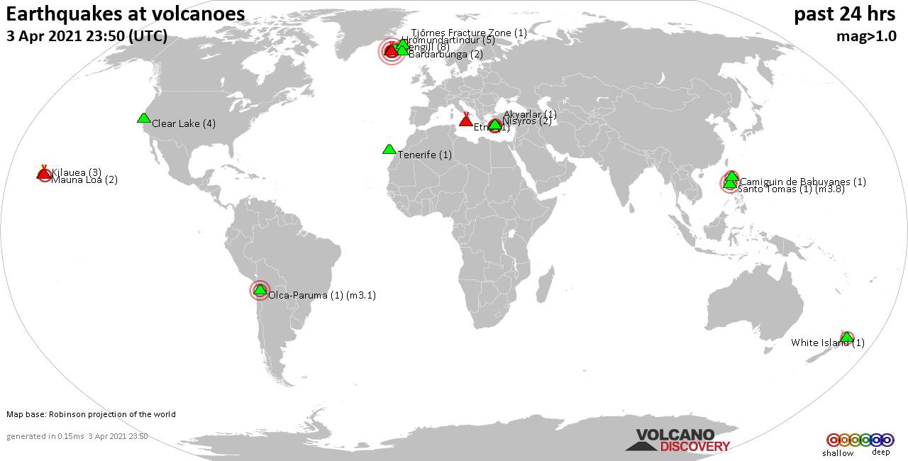
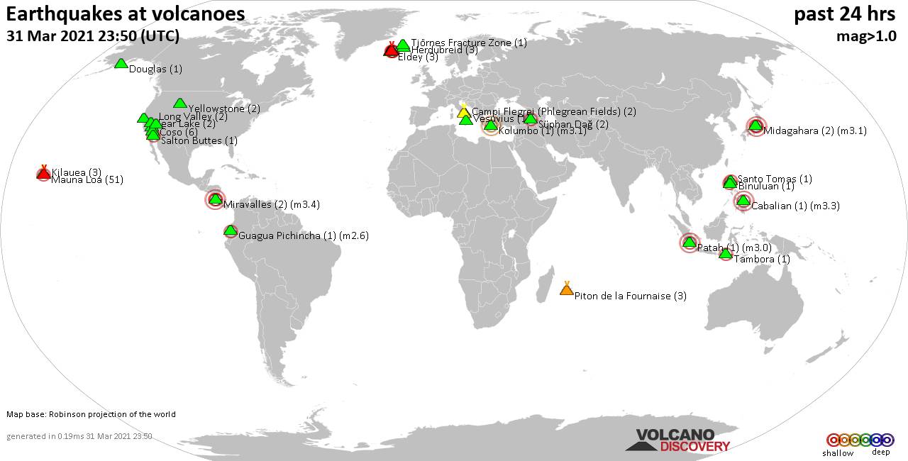
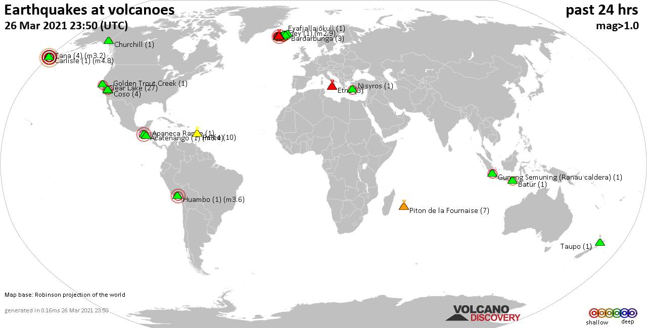
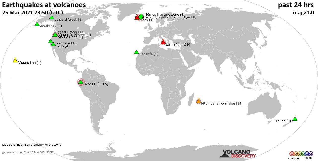
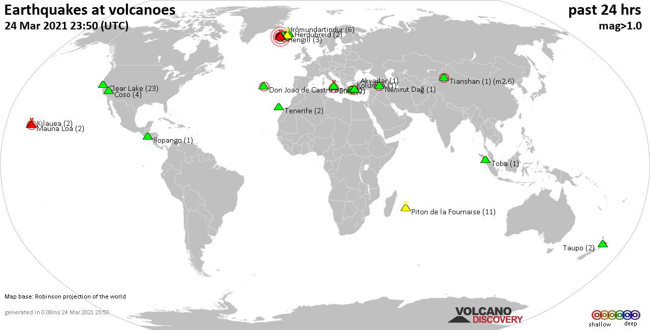
World map showing volcanoes with shallow (less than 20 km) earthquakes within 20 km radius during the past 24 hours on 3 Apr 2021 Number in brackets indicate nr of quakes.
Hengill (8 quakes between mag 0.2-2.3), Hrómundartindur (5 quakes between mag 0.5-1.5), Kilauea (3 quakes between mag 1.8-2.2), Krísuvík (36 quakes between mag 0.1-2.0), Loki-Fögrufjöll volcano (1 quake mag 1.2), Mauna Loa (2 quakes between mag 1.7-1.8), Nisyros (2 quakes between mag 2.1-2.2), Olca-Paruma (1 quake mag 3.1), Prestahnukur (1 quake mag 1.4), Reykjanes (15 quakes between mag 0.2-2.0), Santo Tomas (1 quake mag 3.8), Tenerife (1 quake mag 1.1), Tjörnes Fracture Zone (1 quake mag 2.2), White Island (1 quake mag 2.5), Öraefajökull (1 quake mag 1.9) (updated 23h50)
Note: Earthquakes within 20 km from and at depths less than 20 km under active volcanoes are reported. The list is not complete because many volcanoes are not monitored and/or seismic data in high resolution is not available publicly.
Volcanoes with recent earthquakes above magnitude 2 or more than 10 quakes are listed below:
Fagradalsfjall volcano (Reykjanes Peninsula, Iceland): 22 earthquakes up to magnitude 4.2
Possible earthquake swarm: 22 earthquakes occurred near (under) the volcano during 21 hours, the last being recorded quake 1 hour 57 minutes ago. Hypocenter depths ranged between 6.2 and 0.1 km.Earthquake details: (only 5 largest)
4.2 quake 3.6 Km S of Fagradalsfjall, Iceland, 3 Apr 2021 1:11 am (GMT +0) (3 km S)
1.6 quake 2.9 Km NE of Fagradalsfjall, Iceland, 3 April 2021 03:23 GMT (4 km NE)
1.3 quake 3.3 Km S of Fagradalsfjall, Iceland, 3 Apr 2021 1:11 am (GMT +0) (2 km S)
1.2 quake 3.2 Km SW of Keilir, Iceland, 3 April 2021 07:04 GMT (4 km NE)
0.9 quake 4.8 Km NE of Grindavík, Iceland, 3 April 2021 03:26 GMT (6 km WSW)
All earthquakes at Fagradalsfjall
Hengill volcano (Iceland): 8 earthquakes up to magnitude 2.3
8 earthquakes occurred near (under) the volcano during 5 hours, the last being recorded quake 4 hours ago. Hypocenter depths ranged between 6.5 and 4.4 km.Earthquake details: (only 5 largest)
2.3 quake 4.2 Km SSW of Eiturhóll, Iceland, 3 Apr 2021 7:15 pm (GMT +0) (11 km SSW)
1.0 quake 1.2 Km E of Eiturhóll, Iceland, 3 April 2021 15:09 GMT (6 km SSW)
0.9 quake 3.2 Km SSW of Eiturhóll, Iceland, 3 April 2021 19:25 GMT (10 km SSW)
0.7 quake 3.3 Km SSW of Eiturhóll, Iceland, 3 Apr 2021 7:48 pm (GMT +0) (10 km SSW)
0.7 quake 4.6 Km S of Eiturhóll, Iceland, 3 Apr 2021 7:18 pm (GMT +0) (11 km SSW)
All earthquakes at Hengill
Kilauea volcano (Hawai'i (Big Island)): 3 earthquakes up to magnitude 2.2
3 earthquakes occurred near (under) the volcano during 12 hours, the last being recorded quake 11 hours ago. Hypocenter depths ranged between 8.1 and 0.7 km.Earthquake details:
2.2 quake 13 Km S of Fern Forest, Hawaii, USA, 3 Apr 2021 12:58 am (GMT -10) (18 km ESE)
2.0 quake 15 Km S of Volcano, Hawaii, USA, 3 Apr 2021 3:06 am (GMT -10) (14 km SE)
1.8 quake 14 Km S of Fern Forest, Hawaii, USA, 2 Apr 2021 3:08 pm (GMT -10) (17 km ESE)
All earthquakes at Kilauea
Krísuvík volcano (Reykjanes Peninsula, Iceland): 36 earthquakes up to magnitude 2.0
Possible earthquake swarm: 36 earthquakes occurred near (under) the volcano during 21 hours, the last being recorded quake 3 hours ago. Hypocenter depths ranged between 8.2 and 0.4 km.Earthquake details: (only 5 largest)
2.0 quake 8.4 Km SW of Helgafell, Iceland, 3 Apr 2021 5:40 am (GMT +0) (7 km E)
1.9 quake 3.6 Km ESE of Keilir, Iceland, 3 Apr 2021 9:57 am (GMT +0) (1 km NNW)
1.6 quake 1.4 Km SSW of Keilir, Iceland, 3 Apr 2021 12:15 pm (GMT +0) (5 km W)
1.5 quake 2.1 Km SW of Keilir, Iceland, 3 Apr 2021 9:32 am (GMT +0) (5 km W)
1.4 quake 4.6 Km N of Krýsuvík, Iceland, 3 April 2021 13:23 GMT (1 km E)
All earthquakes at Krísuvík
Nisyros volcano (Greece): 2 earthquakes up to magnitude 2.2
2 earthquakes occurred near (under) the volcano during 3 hours, the last being recorded quake 17 hours ago. Hypocenter depths ranged between 6.0 and 5.4 km.Earthquake details:
2.2 quake Aegean Sea, 25 km west of Tilos Island, Dodecanese, South Aegean, Greece, 3 Apr 2021 9:48 am (GMT +3) (15 km SSW)
2.1 quake Aegean Sea, 20 km west of Tilos Island, Dodecanese, South Aegean, Greece, 3 Apr 2021 7:13 am (GMT +3) (14 km S)
All earthquakes at Nisyros
Olca-Paruma volcano (Northern Chile, Bolivia and Argentina): magnitude 3.1 earthquake
A magnitude 3.1 earthquake occurred at the volcano 16 hours ago. The quake, which might be volcanic in origin, was located at a depth of 11.0 km depth at 13 km distance WNW from the volcano.Earthquake details:
3.1 quake Provincia del Tamarugal, 178 km southeast of Iquique, Tarapaca, Chile, 3 Apr 2021 5:06 am (GMT -3) (13 km WNW)
All earthquakes at Olca-Paruma
Reykjanes volcano (Reykjanes Peninsula, Iceland): 15 earthquakes up to magnitude 2.0
Possible earthquake swarm: 15 earthquakes occurred near (under) the volcano during 17 hours, the last being recorded quake 5 hours ago. Hypocenter depths ranged between 6.2 and 0.1 km.Earthquake details: (only 5 largest)
2.0 quake 1.8 Km WNW of Reykjanestá, Iceland, 3 Apr 2021 2:35 pm (GMT +0) (15 km SW)
1.4 quake 2.5 Km WNW of Reykjanestá, Iceland, 3 April 2021 15:21 GMT (14 km SW)
1.2 quake 1.8 Km NE of Grindavík, Iceland, 3 April 2021 11:20 GMT (7 km SE)
1.2 quake 5.4 Km WNW of Grindavík, Iceland, 3 Apr 2021 12:01 pm (GMT +0) (5 km SSW)
1.1 quake 4.7 Km W of Grindavík, Iceland, 3 April 2021 04:07 GMT (6 km S)
All earthquakes at Reykjanes
Santo Tomas volcano (Luzon Island): magnitude 3.8 earthquake
A magnitude 3.8 earthquake occurred at the volcano 1 hour 10 minutes ago. The quake, which might be volcanic in origin, was located at a depth of 9.0 km depth at 19 km distance NE from the volcano.Earthquake details:
3.8 quake 9.3 km northeast of Baguio City, Province of Benguet, Cordillera, Philippines, 4 Apr 2021 6:40 am (GMT +8) (19 km NE)
All earthquakes at Santo Tomas
Tjörnes Fracture Zone volcano (Iceland): magnitude 2.2 earthquake
A magnitude 2.2 earthquake occurred at the volcano 15 hours ago. The quake, which might be volcanic in origin, was located at a depth of 11.5 km depth at 6 km distance ESE from the volcano.Earthquake details:
2.2 quake 24.5 Km W of Kópasker, Iceland, 3 Apr 2021 9:08 am (GMT +0) (6 km ESE)
All earthquakes at Tjörnes Fracture Zone
White Island volcano (New Zealand): magnitude 2.5 earthquake
A magnitude 2.5 earthquake occurred at the volcano 9 hours ago. The quake, which might be volcanic in origin, was located at a depth of 2.9 km depth at 3 km distance SW from the volcano.Earthquake details:
2.5 quake South Pacific Ocean, 49 km north of Whakatane, Bay of Plenty, New Zealand, 4 Apr 2021 2:54 am (GMT +12) (3 km SW)
All earthquakes at White Island
Previous news
Fri, 2 Apr 2021, 23:50
Volcano earthquake report for Friday, 2 Apr 2021
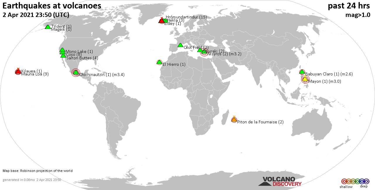
Quakes detected near: Babuyan Claro (1 quake mag 2.6), Brennisteinsfjöll (3 quakes between mag 0.2-1.5), Chichinautzin (1 quake mag 3.4), Coso (8 quakes between mag 0.2-1.9), El Hierro (1 quake mag 2.3), Eldey (1 quake mag 1.5) ... Read all
Thu, 1 Apr 2021, 23:50
Volcano earthquake report for Thursday, 1 Apr 2021
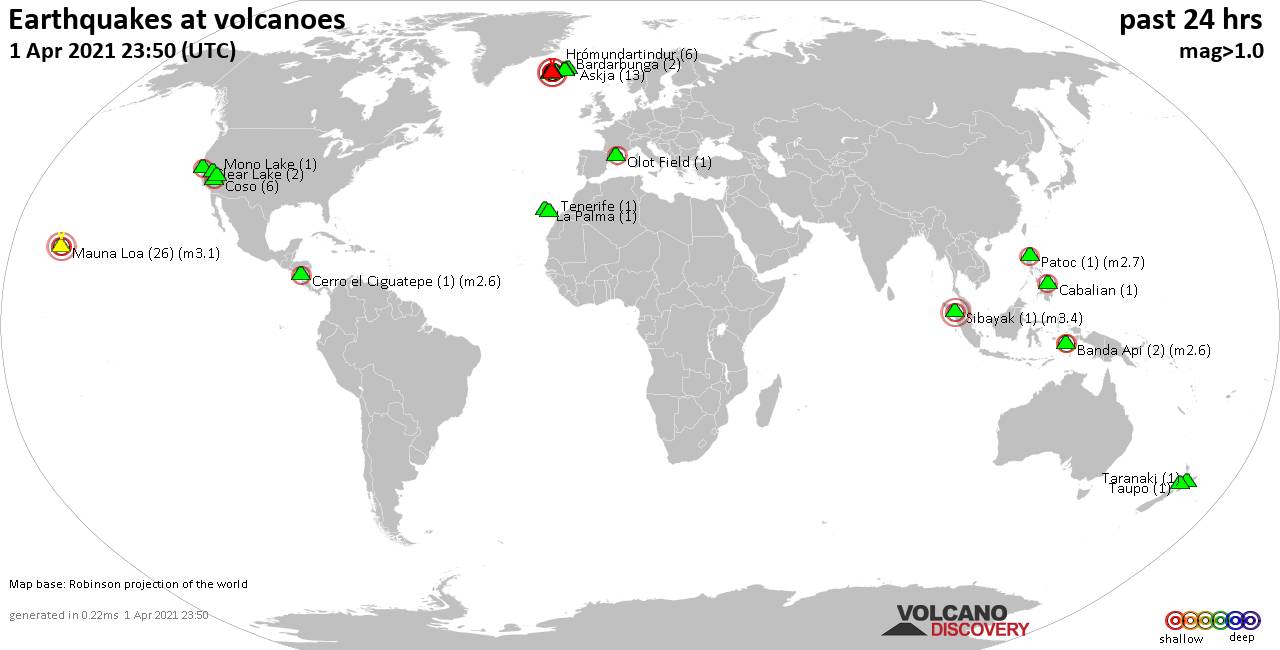
Quakes detected near: Askja (13 quakes between mag 0.3-1.6), Banda Api (2 quakes between mag 2.3-2.6), Bardarbunga (2 quakes between mag 0.9-1.8), Brennisteinsfjöll (8 quakes between mag 0.1-1.5), Cabalian (1 quake mag 2.0), Cerro el Ciguatepe (1 quake mag 2.6) ... Read all
Show more