Volcano earthquake report for Sunday, 13 Jun 2021
Sun, 13 Jun 2021, 23:50 | BY: EARTHQUAKEMONITOR
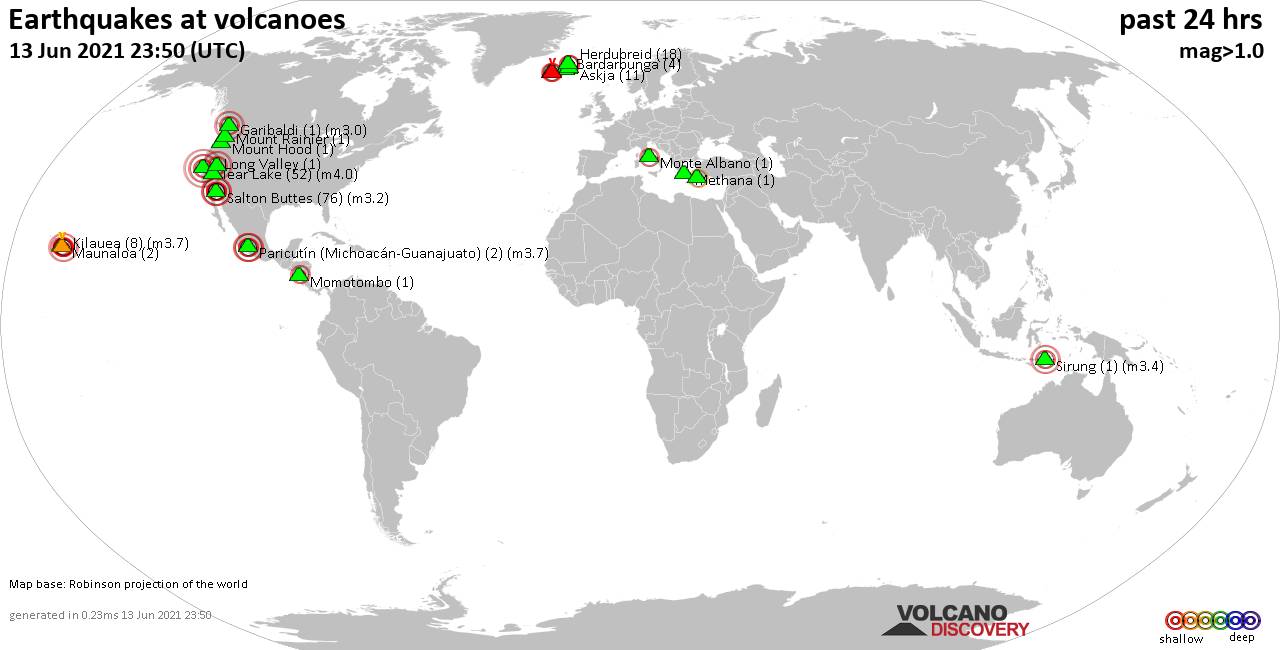
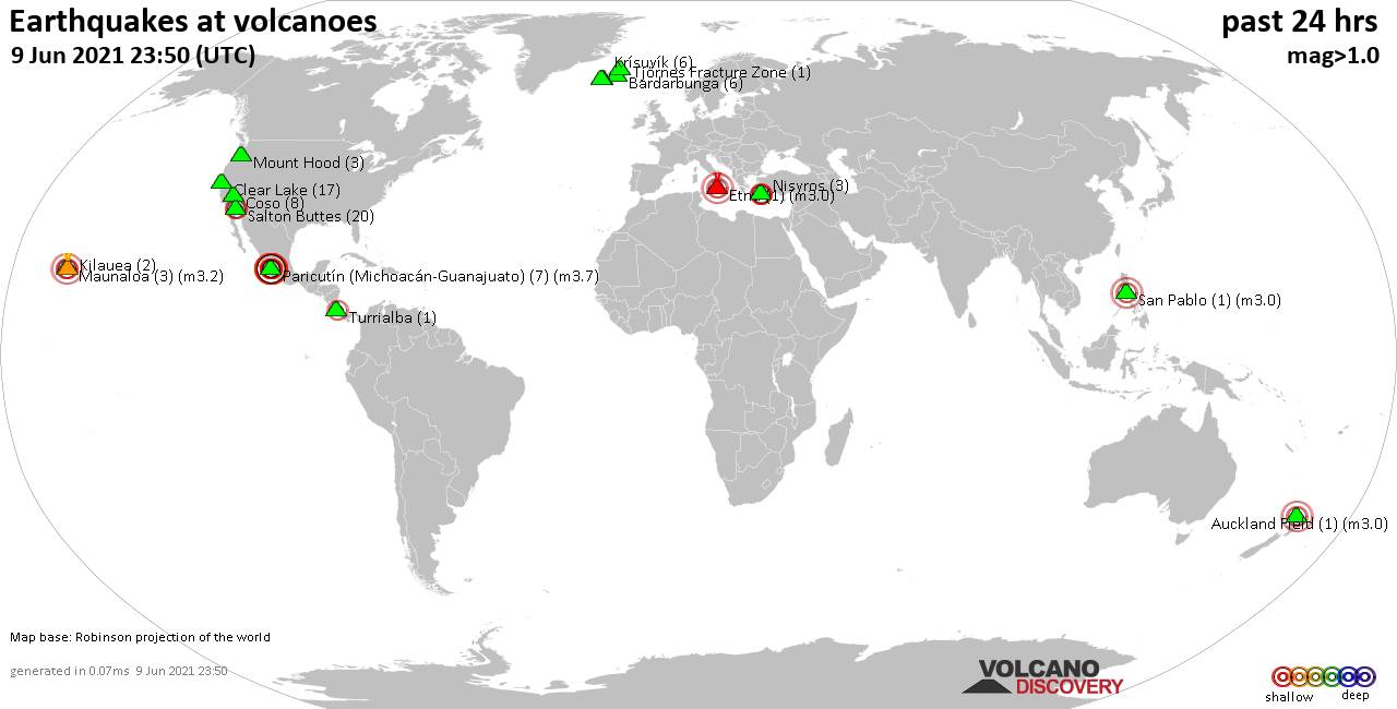
World map showing volcanoes with shallow (less than 20 km) earthquakes within 20 km radius during the past 24 hours on 13 Jun 2021 Number in brackets indicate nr of quakes.
Kilauea (8 quakes between mag 1.7-3.7), Krísuvík (2 quakes between mag 1.2-1.3), Long Valley (1 quake mag 1.1), Maunaloa (2 quakes between mag 1.9-2.1), Methana (1 quake mag 1.2), Momotombo (1 quake mag 2.2), Monte Albano (1 quake mag 2.5), Mount Hood (1 quake mag 1.2), Mount Rainier (1 quake mag 1.0), Nisyros (2 quakes between mag 1.9-2.2), Paricutín (Michoacán-Guanajuato) (2 quakes between mag 3.5-3.7), Reykjanes (8 quakes between mag 0.1-2.0), Salton Buttes (76 quakes between mag 0.6-3.2), Sirung (1 quake mag 3.4), Soda Lakes (1 quake mag 3.0), Tjörnes Fracture Zone (23 quakes between mag 0.5-2.9) (updated 23h50)
Note: Earthquakes within 20 km from and at depths less than 20 km under active volcanoes are reported. The list is not complete because many volcanoes are not monitored and/or seismic data in high resolution is not available publicly.
Volcanoes with recent earthquakes above magnitude 2 or more than 10 quakes are listed below:
Askja volcano (Iceland): 11 earthquakes up to magnitude 1.9
Possible earthquake swarm: 11 earthquakes occurred near (under) the volcano during 18 hours, the last being recorded quake 5 hours ago. Hypocenter depths ranged between 9.5 and 3.6 km.Earthquake details: (only 5 largest)
1.9 quake Iceland: 3.2 Km NE of Dreki 13 June 2021 02:43 GMT (10 km ENE)
1.4 quake Iceland: 7.4 Km ESE of Dreki 13 June 2021 18:22 GMT (14 km E)
0.9 quake Iceland: 3.3 Km NE of Dreki 13 June 2021 12:50 GMT (10 km ENE)
0.9 quake Iceland: 3.5 Km NE of Dreki 13 June 2021 12:50 GMT (10 km ENE)
0.7 quake Iceland: 3.6 Km NE of Dreki 13 June 2021 12:38 GMT (10 km ENE)
All earthquakes at Askja
Clear Lake volcano (California): 52 earthquakes up to magnitude 4.0
Possible earthquake swarm: 52 earthquakes occurred near (under) the volcano during 22 hours, the last being recorded quake 60 minutes ago. Hypocenter depths ranged between 3.5 and 0.7 km.Earthquake details: (only 5 largest)
4.0 quake 26 mi north of Santa Rosa, Sonoma County, California, USA, 12 Jun 2021 11:54 pm (GMT -7) (19 km SSW)
1.7 quake 8km WNW of The Geysers, CA, 13 June 2021 09:21 GMT (19 km SSW)
1.6 quake 4km W of Cobb, CA, 13 June 2021 22:50 GMT (17 km S)
1.6 quake 7km WNW of The Geysers, CA, 13 June 2021 16:55 GMT (18 km SSW)
1.4 quake 5km WNW of The Geysers, CA, 13 June 2021 07:38 GMT (19 km S)
All earthquakes at Clear Lake
Garibaldi volcano (Canada): magnitude 3.0 earthquake
A magnitude 3.0 earthquake occurred at the volcano 5 hours ago. The quake, which might be volcanic in origin, was located at a depth of 10.0 km depth at 15 km distance SW from the volcano.Earthquake details:
Unconfirmed quake reported: 5.4 km north of Squamish, British Columbia, Canada, 13 June 2021 18:44 GMT (15 km SW)
All earthquakes at Garibaldi
Herdubreid volcano (Iceland): 18 earthquakes up to magnitude 1.3
Possible earthquake swarm: 18 earthquakes occurred near (under) the volcano during 13 hours, the last being recorded quake 6 hours ago. Hypocenter depths ranged between 12.7 and 3.5 km.Earthquake details: (only 5 largest)
1.3 quake Iceland: 3.0 Km NW of Herðubreiðarlindir 13 June 2021 12:19 GMT (5 km NE)
1.1 quake Iceland: 2.9 Km NW of Herðubreiðarlindir 13 June 2021 13:13 GMT (5 km NE)
0.9 quake Iceland: 2.5 Km NW of Herðubreiðarlindir 13 June 2021 13:35 GMT (6 km NE)
0.8 quake Iceland: 2.8 Km NW of Herðubreiðarlindir 13 June 2021 11:49 GMT (5 km NE)
0.8 quake Iceland: 3.0 Km NW of Herðubreiðarlindir 13 June 2021 13:13 GMT (5 km NE)
All earthquakes at Herdubreid
Kilauea volcano (Hawai'i (Big Island)): 8 earthquakes up to magnitude 3.7
8 earthquakes occurred near (under) the volcano during 20 hours, the last being recorded quake 3 hours ago. Hypocenter depths ranged between 7.4 and 0.2 km.Earthquake details: (only 5 largest)
3.7 quake 30 mi south of Hilo, Hawaii County, USA, 12 Jun 2021 3:19 pm (GMT -10) (13 km SE)
2.3 quake 7 Km S of Volcano, Hawaii, 13 June 2021 12:44 GMT (7 km ESE)
2.1 quake 7 Km SSE of Volcano, Hawaii, 13 June 2021 00:49 GMT (8 km ESE)
2.0 quake 7 Km SSE of Volcano, Hawaii, 13 June 2021 13:42 GMT (8 km ESE)
1.9 quake 7 Km SW of Volcano, Hawaii, 13 June 2021 15:31 GMT (0 km SSW)
All earthquakes at Kilauea
Maunaloa volcano (Hawai'i (Big Island)): 2 earthquakes up to magnitude 2.1
2 earthquakes occurred near (under) the volcano during 8 hours, the last being recorded quake 11 hours ago. Hypocenter depths ranged between 3.2 and 0.2 km.Earthquake details:
2.1 quake 13 Km E of Honaunau-Napoopoo, Hawaii, 13 June 2021 12:55 GMT (14 km W)
1.9 quake 23 Km W of Volcano, Hawaii, 13 June 2021 05:03 GMT (16 km E)
All earthquakes at Maunaloa
Momotombo volcano (Nicaragua): magnitude 2.2 earthquake
A magnitude 2.2 earthquake occurred at the volcano 19 hours ago. The quake, which might be volcanic in origin, was located at a depth of 5.0 km depth at 17 km distance NNE from the volcano.Earthquake details:
2.2 quake 45 km east of Leon, Nicaragua, 2021-06-12 22:20:16 (17 km NNE)
All earthquakes at Momotombo
Monte Albano volcano (Italy): magnitude 2.5 earthquake
A magnitude 2.5 earthquake occurred at the volcano 19 hours ago. The quake, which might be volcanic in origin, was located at a depth of 10.8 km depth at 11 km distance S from the volcano.Earthquake details:
2.5 quake 7.1 km southwest of Velletri, Rome, Latium, Italy, 13 June 2021 04:24 GMT (11 km S)
All earthquakes at Monte Albano
Nisyros volcano (Greece): 2 earthquakes up to magnitude 2.2
2 earthquakes occurred near (under) the volcano during 6 hours, the last being recorded quake 6 hours ago. Hypocenter depths ranged between 14.8 and 7.8 km.Earthquake details:
2.2 quake Aegean Sea, 45 km south of Kos Town, Dodecanese, South Aegean, Greece, 13 June 2021 11:18 GMT (15 km SE)
1.9 quake Aegean Sea, 46 km south of Kos Town, Dodecanese, South Aegean, Greece, 13 June 2021 17:23 GMT (9 km SSW)
All earthquakes at Nisyros
Paricutín (Michoacán-Guanajuato) volcano (Western & Central Mexico): 2 earthquakes up to magnitude 3.7
2 earthquakes occurred near (under) the volcano during 42 minutes, the last being recorded quake 16 hours ago. Hypocenter depths ranged between 8.0 and 8.0 km.Earthquake details:
3.7 quake Nuevo Parangaricutiro, 19 km southwest of Uruapan, Michoacan, Mexico, 2021-06-13 03:08:46 (Hora de México) (17 km S)
3.5 quake Nuevo Parangaricutiro, 18 km west of Uruapan, Michoacan, Mexico, 2021-06-13 02:27:13 (Hora de México) (14 km SSE)
All earthquakes at Paricutín (Michoacán-Guanajuato)
Salton Buttes volcano (California): 76 earthquakes up to magnitude 3.2
Possible earthquake swarm: 76 earthquakes occurred near (under) the volcano during 23 hours, the last being recorded quake 37 minutes ago. Hypocenter depths ranged between 18.7 and 1.2 km.Earthquake details: (only 5 largest)
3.2 quake 13 mi northwest of Brawley, Imperial County, California, USA, 13 Jun 2021 11:20 am (GMT -7) (7 km SSW)
3.1 quake 13 mi northwest of Brawley, Imperial County, California, USA, 13 Jun 2021 10:43 am (GMT -7) (7 km SSW)
2.1 quake 14km S of Bombay Beach, CA, 13 June 2021 23:13 GMT (13 km W)
2.0 quake 10km WSW of Niland, CA, 13 June 2021 01:48 GMT (1 km NNW)
1.9 quake 10km WSW of Niland, CA, 12 June 2021 23:58 GMT (2 km N)
All earthquakes at Salton Buttes
Sirung volcano (Lesser Sunda Islands): magnitude 3.4 earthquake
A magnitude 3.4 earthquake occurred at the volcano 3 hours ago. The quake, which might be volcanic in origin, was located at a depth of 10.0 km depth at 7 km distance SE from the volcano.Earthquake details:
3.4 quake Savu Sea, 35 km southwest of Pura Island, East Nusa Tenggara, Indonesia, 13 June 2021 20:49 GMT (7 km SE)
All earthquakes at Sirung
Soda Lakes volcano (Nevada): magnitude 3.0 earthquake
A magnitude 3.0 earthquake occurred at the volcano 11 hours ago. The quake, which might be volcanic in origin, was located at a depth of 10.0 km depth at 10 km distance ESE from the volcano.Earthquake details:
Unconfirmed quake reported: 0.7 mi north of Fallon, Churchill County, Nevada, USA, 13 June 2021 13:04 GMT (10 km ESE)
All earthquakes at Soda Lakes
Tjörnes Fracture Zone volcano (Iceland): 23 earthquakes up to magnitude 2.9
Possible earthquake swarm: 23 earthquakes occurred near (under) the volcano during 12 hours, the last being recorded quake 4 hours ago. Hypocenter depths ranged between 17.4 and 4.8 km.Earthquake details: (only 5 largest)
2.9 quake Iceland: 12.5 Km WSW of Kópasker 13 June 2021 07:47 GMT (17 km ESE)
2.2 quake Iceland: 12.7 Km WSW of Kópasker 13 June 2021 09:09 GMT (17 km ESE)
1.7 quake Iceland: 12.8 Km WSW of Kópasker 13 June 2021 14:34 GMT (18 km ESE)
1.6 quake Iceland: 12.5 Km WSW of Kópasker 13 June 2021 19:01 GMT (18 km ESE)
1.6 quake Iceland: 12.7 Km WSW of Kópasker 13 June 2021 08:14 GMT (18 km ESE)
All earthquakes at Tjörnes Fracture Zone
Previous news
Fri, 11 Jun 2021, 23:50
Volcano earthquake report for Friday, 11 Jun 2021
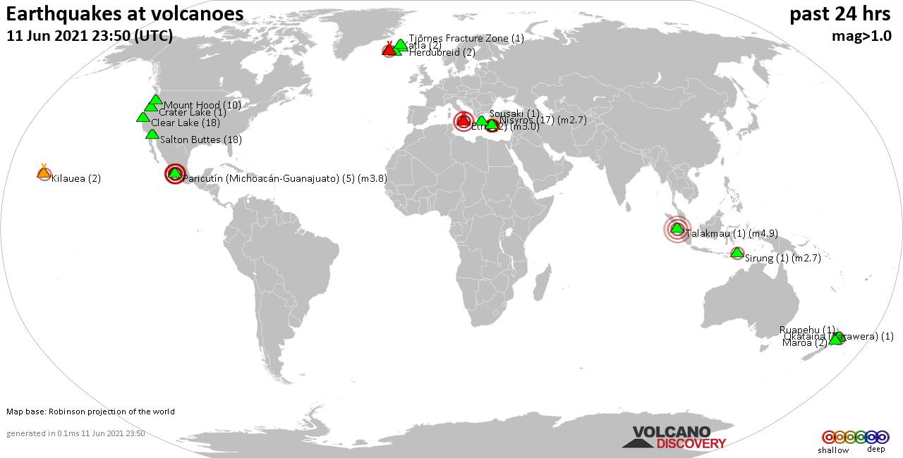
Quakes detected near: Clear Lake (18 quakes between mag 0.4-1.4), Crater Lake (1 quake mag 1.1), Etna (2 quakes between mag 3.0-3.0), Fagradalsfjall (2 quakes between mag 0.3-1.1), Herdubreid (2 quakes between mag 0.4-1.4), Katla (2 quakes between mag 0.9-1.8) ... Read all
Show more