Volcano earthquake report for Saturday, 19 Jun 2021
Sat, 19 Jun 2021, 23:50 | BY: EARTHQUAKEMONITOR
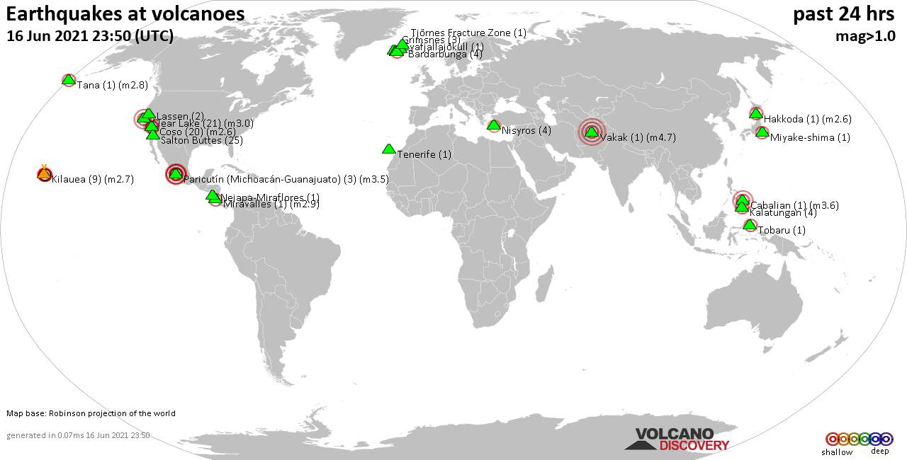
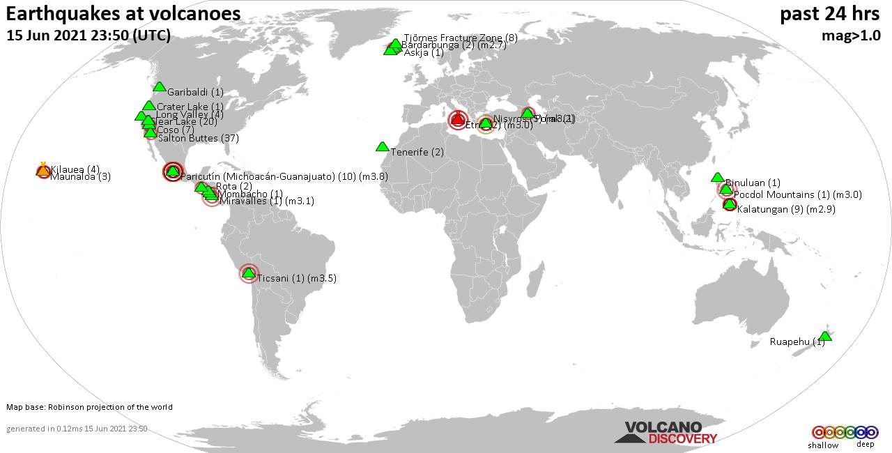
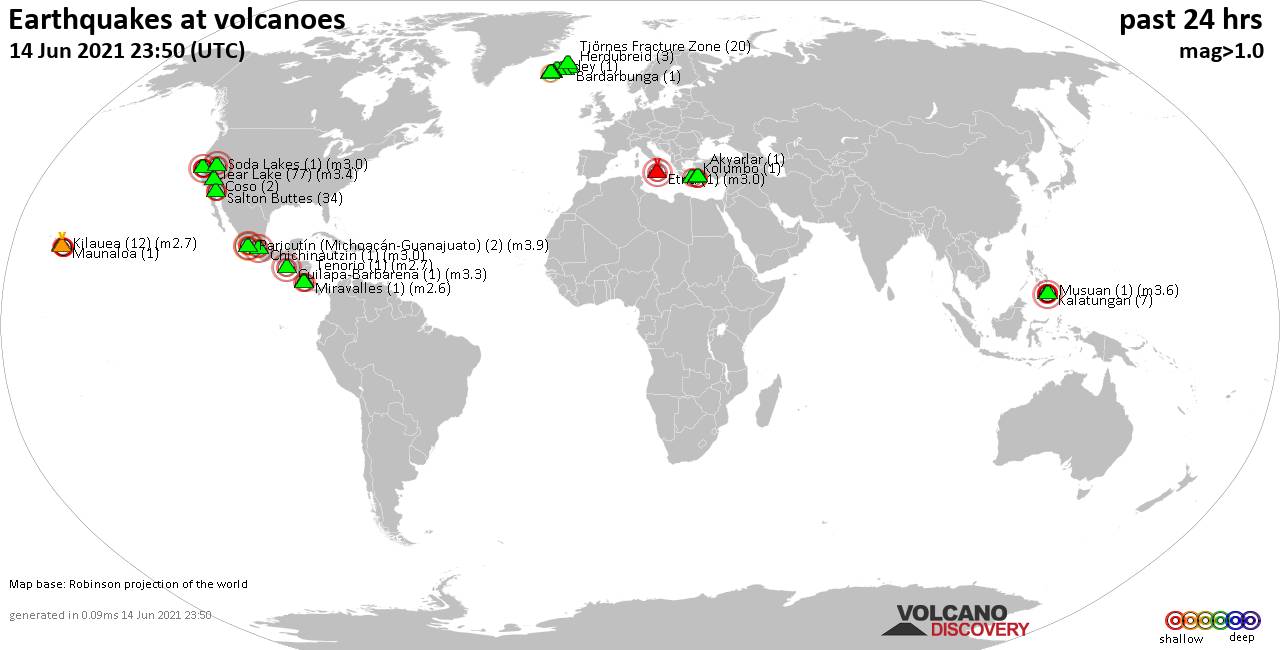
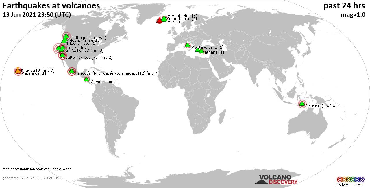
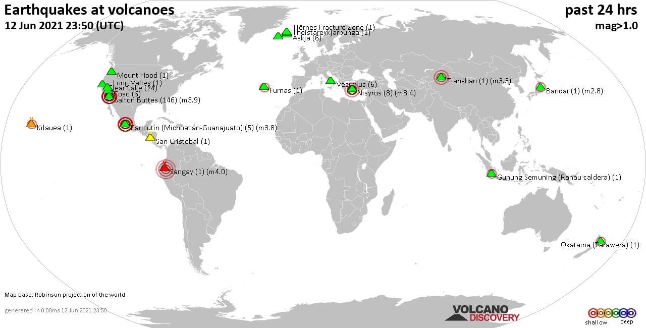
World map showing volcanoes with shallow (less than 20 km) earthquakes within 20 km radius during the past 24 hours on 19 Jun 2021 Number in brackets indicate nr of quakes.
Hrómundartindur (3 quakes between mag 0.3-1.3), Kalatungan (1 quake mag 1.9), Katla (2 quakes between mag 0.3-1.2), Katmai (1 quake mag 1.7), Kverkfjöll (2 quakes between mag 0.3-1.2), Long Valley (3 quakes between mag 0.5-1.9), Monte Albano (1 quake mag 1.8), Nevados Casiri (1 quake mag 3.4), Numazawa (1 quake mag 2.7), Paricutín (Michoacán-Guanajuato) (3 quakes between mag 3.5-3.8), Salton Buttes (19 quakes between mag 0.6-1.9), San Salvador (1 quake mag 2.5), Tjörnes Fracture Zone (1 quake mag 1.1), Öraefajökull (2 quakes between mag 0.5-1.1) (updated 23h50)
Note: Earthquakes within 20 km from and at depths less than 20 km under active volcanoes are reported. The list is not complete because many volcanoes are not monitored and/or seismic data in high resolution is not available publicly.
Volcanoes with recent earthquakes above magnitude 2 or more than 10 quakes are listed below:
Campi Flegrei (Phlegrean Fields) volcano (Italy): 2 earthquakes up to magnitude 3.0
2 earthquakes occurred near (under) the volcano at nearly the same time (18:28 UTC). Hypocenter depths ranged between 10.0 and 2.3 km.Earthquake details:
Unconfirmed quake reported: 12 km west of nepalasa, Naples, Campania, Italy, 19 June 2021 18:28 GMT (1 km WNW)
1.7 quake 5.3 km west of Fuorigrotta, Naples, Campania, Italy, 19 June 2021 18:27 GMT (0 km ENE)
All earthquakes at Campi Flegrei (Phlegrean Fields)
Clear Lake volcano (California): 20 earthquakes up to magnitude 1.5
Possible earthquake swarm: 20 earthquakes occurred near (under) the volcano during 23 hours, the last being recorded quake 48 minutes ago. Hypocenter depths ranged between 4.7 and 0.8 km.Earthquake details: (only 5 largest)
1.5 quake 9km WNW of Cobb, CA, 19 June 2021 03:57 GMT (15 km SSW)
1.3 quake 3km E of Lower Lake, CA, 19 June 2021 03:24 GMT (18 km ESE)
1.0 quake 7km W of Cobb, CA, 19 June 2021 19:26 GMT (15 km SSW)
1.0 quake 7km W of Cobb, CA, 19 June 2021 18:27 GMT (16 km S)
1.0 quake 7km W of Cobb, CA, 19 June 2021 17:50 GMT (15 km S)
All earthquakes at Clear Lake
Don Joao de Castro Bank volcano (Azores): 5 earthquakes up to magnitude 3.5
5 earthquakes occurred near (under) the volcano during 4 hours, the last being recorded quake 17 hours ago. Hypocenter depths ranged between 1.0 and 0.0 km.Earthquake details:
3.5 quake North Atlantic Ocean, 98 km northwest of Ponta Delgada, Azores, Portugal, 19 June 2021 05:01 GMT (6 km S)
3.5 quake North Atlantic Ocean, 72 km southeast of Angra do Heroismo, Azores, Portugal, 19 June 2021 03:47 GMT (7 km SSW)
2.6 quake North Atlantic Ocean, 99 km northwest of Ponta Delgada, Azores, Portugal, 19 June 2021 05:04 GMT (5 km SSW)
2.4 quake North Atlantic Ocean, 99 km northwest of Ponta Delgada, Azores, Portugal, 19 June 2021 04:53 GMT (7 km SSW)
2.3 quake North Atlantic Ocean, 99 km northwest of Ponta Delgada, Azores, Portugal, 19 June 2021 07:19 GMT (1 km ESE)
All earthquakes at Don Joao de Castro Bank
Nevados Casiri volcano (Peru): magnitude 3.4 earthquake
A magnitude 3.4 earthquake occurred at the volcano 21 hours ago. The quake, which might be volcanic in origin, was located at a depth of 15.0 km depth at 4 km distance NNE from the volcano.Earthquake details:
3.4 quake Provincia de Tarata, 73 km northeast of Tacna, Peru, 19 June 2021 02:39 GMT (4 km NNE)
All earthquakes at Nevados Casiri
Numazawa volcano (Honshu): magnitude 2.7 earthquake
A magnitude 2.7 earthquake occurred at the volcano 17 hours ago. The quake, which might be volcanic in origin, was located at a depth of 7.0 km depth at 17 km distance SSE from the volcano.Earthquake details:
2.7 quake Ōnuma-gun, 44 km southwest of Kitakata, Fukushima, Japan, Jun 19, 2021 15:47:13.88 (17 km SSE)
All earthquakes at Numazawa
Paricutín (Michoacán-Guanajuato) volcano (Western & Central Mexico): 3 earthquakes up to magnitude 3.8
3 earthquakes occurred near (under) the volcano during 2 hours, the last being recorded quake 15 hours ago. Hypocenter depths ranged between 15.0 and 12.0 km.Earthquake details:
3.8 quake 17 km southwest of Uruapan, Michoacan, Mexico, 2021-06-19 02:57:36 (Hora de México) (19 km SSE)
3.7 quake Nuevo Parangaricutiro, 16 km west of Uruapan, Michoacan, Mexico, 2021-06-19 04:03:39 (Hora de México) (16 km SSE)
3.5 quake Nuevo Parangaricutiro, 17 km west of Uruapan, Michoacan, Mexico, 2021-06-19 01:36:40 (Hora de México) (14 km SSE)
All earthquakes at Paricutín (Michoacán-Guanajuato)
Salton Buttes volcano (California): 19 earthquakes up to magnitude 1.9
Possible earthquake swarm: 19 earthquakes occurred near (under) the volcano during 20 hours, the last being recorded quake 2 hours ago. Hypocenter depths ranged between 19.9 and 1.2 km.Earthquake details: (only 5 largest)
1.9 quake 13km WSW of Niland, CA, 19 June 2021 12:35 GMT (3 km SW)
1.9 quake 12km W of Niland, CA, 19 June 2021 07:01 GMT (10 km NW)
1.6 quake 10km W of Niland, CA, 19 June 2021 02:01 GMT (3 km N)
1.5 quake 14km WSW of Niland, CA, 19 June 2021 21:35 GMT (12 km WSW)
1.5 quake 8km W of Niland, CA, 19 June 2021 03:43 GMT (4 km NNE)
All earthquakes at Salton Buttes
San Salvador volcano (El Salvador): magnitude 2.5 earthquake
A magnitude 2.5 earthquake occurred at the volcano 22 hours ago. The quake, which might be volcanic in origin, was located at a depth of 13.0 km depth at 12 km distance WNW from the volcano.Earthquake details:
2.5 quake Departamento de La Libertad, 25 km west of San Salvador, El Salvador, 2021-06-18 19:44:27 (12 km WNW)
All earthquakes at San Salvador
Previous news
Fri, 18 Jun 2021, 23:50
Volcano earthquake report for Friday, 18 Jun 2021
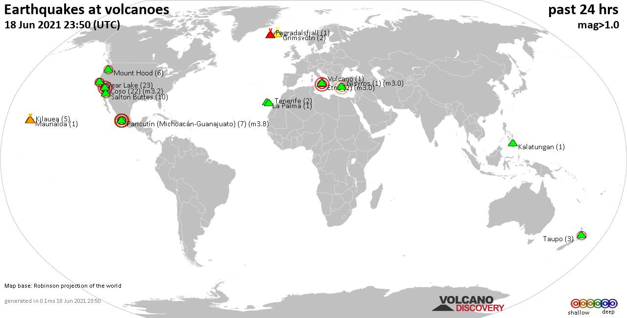
Quakes detected near: Clear Lake (23 quakes between mag 0.2-2.5), Coso (22 quakes between mag 0.4-3.2), Etna (2 quakes between mag 3.0-3.0), Fagradalsfjall (1 quake mag 1.1), Grímsvötn (2 quakes between mag 0.5-1.8), Kalatungan (1 quake mag 1.9) ... Read all
Thu, 17 Jun 2021, 23:50
Volcano earthquake report for Thursday, 17 Jun 2021
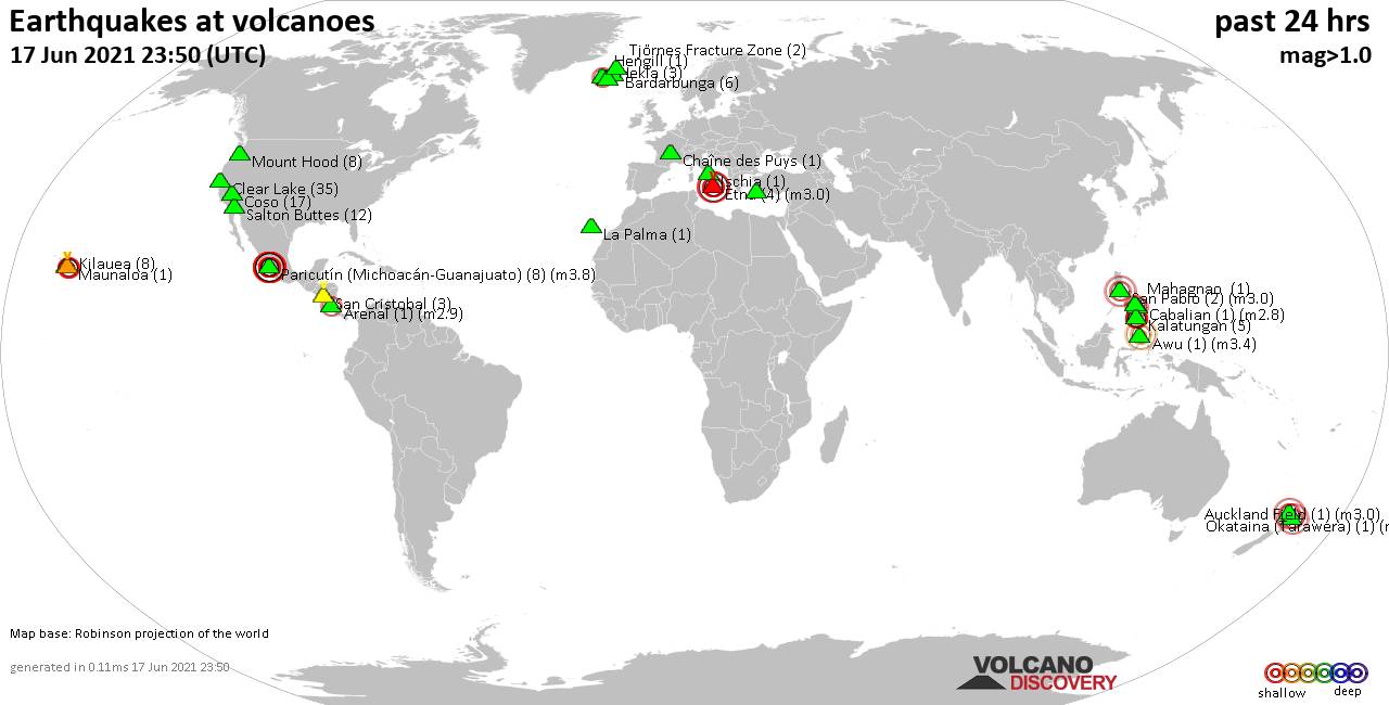
Quakes detected near: Arenal (1 quake mag 2.9), Auckland Field (1 quake mag 3.0), Awu (1 quake mag 3.4), Bardarbunga (6 quakes between mag 0.5-1.8), Cabalian (1 quake mag 2.8), Chaîne des Puys (1 quake mag 1.3) ... Read all
Show more