Volcano earthquake report for Tuesday, 6 Jul 2021
Tue, 6 Jul 2021, 23:50 | BY: EARTHQUAKEMONITOR
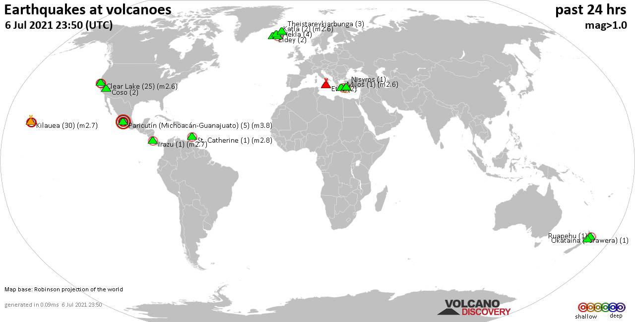
World map showing volcanoes with shallow (less than 20 km) earthquakes within 20 km radius during the past 24 hours on 6 Jul 2021 Number in brackets indicate nr of quakes.
Irazu (1 quake mag 2.7), Katla (2 quakes between mag 1.2-2.6), Kilauea (30 quakes between mag 0.3-2.7), Milos (1 quake mag 2.6), Nisyros (1 quake mag 2.4), Okataina (Tarawera) (1 quake mag 2.5), Paricutín (Michoacán-Guanajuato) (5 quakes between mag 3.8-3.8), Prestahnukur (1 quake mag 1.6), Ruapehu (1 quake mag 1.1), St. Catherine (1 quake mag 2.8), Theistareykjarbunga (3 quakes between mag 0.3-1.0), Tjörnes Fracture Zone (3 quakes between mag 0.8-1.2) (updated 23h50)
Note: Earthquakes within 20 km from and at depths less than 20 km under active volcanoes are reported. The list is not complete because many volcanoes are not monitored and/or seismic data in high resolution is not available publicly.
Volcanoes with recent earthquakes above magnitude 2 or more than 10 quakes are listed below:
Clear Lake volcano (California): 25 earthquakes up to magnitude 2.6
Possible earthquake swarm: 25 earthquakes occurred near (under) the volcano during 20 hours, the last being recorded quake 2 hours ago. Hypocenter depths ranged between 4.0 and 0.6 km.Earthquake details: (only 5 largest)
2.6 quake 6km NNW of The Geysers, CA, 6 July 2021 20:33 GMT (17 km S)
2.4 quake 7km W of Cobb, CA, 6 July 2021 01:18 GMT (15 km SSW)
1.1 quake 6km NNW of The Geysers, CA, 6 July 2021 20:34 GMT (17 km S)
1.0 quake 5km W of Cobb, CA, 6 July 2021 18:13 GMT (16 km S)
1.0 quake 7km WNW of Cobb, CA, 6 July 2021 16:08 GMT (15 km SSW)
All earthquakes at Clear Lake
Irazu volcano (Costa Rica): magnitude 2.7 earthquake
A magnitude 2.7 earthquake occurred at the volcano 14 hours ago. The quake, which might be volcanic in origin, was located at a depth of 5.0 km depth at 7 km distance NW from the volcano.Earthquake details:
2.7 quake Goicoechea, 22 km northeast of San Jose, San José, Costa Rica, 06 de julio del 2021 3:21 am (7 km NW)
All earthquakes at Irazu
Katla volcano (Iceland): 2 earthquakes up to magnitude 2.6
2 earthquakes occurred near (under) the volcano during 4 hours, the last being recorded quake 13 hours ago. Hypocenter depths ranged between 11.3 and 2.9 km.Earthquake details:
2.6 quake Iceland: 1.3 Km SW of Goðabunga 6 July 2021 10:42 GMT (11 km W)
1.2 quake Iceland: 4.5 Km SE of Goðabunga 6 July 2021 07:10 GMT (7 km WSW)
All earthquakes at Katla
Kilauea volcano (Hawai'i (Big Island)): 30 earthquakes up to magnitude 2.7
Possible earthquake swarm: 30 earthquakes occurred near (under) the volcano during 22 hours, the last being recorded quake 1 hour 40 minutes ago. Hypocenter depths ranged between 6.2 and 0.2 km.Earthquake details: (only 5 largest)
2.7 quake 26 mi south of Hilo, Hawaii County, USA, 6 July 2021 00:39 GMT (9 km ESE)
2.5 quake 8 Km SSE of Volcano, Hawaii, 6 July 2021 22:10 GMT (9 km ESE)
2.1 quake 5 Km SSW of Volcano, Hawaii, 6 July 2021 02:53 GMT (4 km ESE)
2.0 quake 8 Km SSE of Volcano, Hawaii, 6 July 2021 09:15 GMT (9 km ESE)
1.9 quake 8 Km SSE of Volcano, Hawaii, 6 July 2021 09:23 GMT (9 km ESE)
All earthquakes at Kilauea
Milos volcano (Greece): magnitude 2.6 earthquake
A magnitude 2.6 earthquake occurred at the volcano 16 hours ago. The quake, which might be volcanic in origin, was located at a depth of 9.3 km depth at 15 km distance E from the volcano.Earthquake details:
2.6 quake Aegean Sea, 96 km east of Adamantas, Nomos Kykladon, South Aegean, Greece, 6 July 2021 08:12 GMT (15 km E)
All earthquakes at Milos
Nisyros volcano (Greece): magnitude 2.4 earthquake
A magnitude 2.4 earthquake occurred at the volcano 1 hour 48 minutes ago. The quake, which might be volcanic in origin, was located at a depth of 13.8 km depth at 10 km distance S from the volcano.Earthquake details:
2.4 quake Aegean Sea, 46 km south of Kos Town, Dodecanese, South Aegean, Greece, 6 July 2021 22:02 GMT (10 km S)
All earthquakes at Nisyros
Okataina (Tarawera) volcano (New Zealand): magnitude 2.5 earthquake
A magnitude 2.5 earthquake occurred at the volcano 19 hours ago. The quake, which might be volcanic in origin, was located at a depth of 4.7 km depth at 14 km distance N from the volcano.Earthquake details:
2.5 quake 28 km northeast of Rotorua, Bay of Plenty, New Zealand, 6 July 2021 04:32 GMT (14 km N)
All earthquakes at Okataina (Tarawera)
Paricutín (Michoacán-Guanajuato) volcano (Western & Central Mexico): 5 earthquakes up to magnitude 3.8
5 earthquakes occurred near (under) the volcano during 1 hour 21 minutes, the last being recorded quake 14 hours ago. Hypocenter depths ranged between 15.0 and 7.0 km.Earthquake details:
3.8 quake 27 km northwest of Uruapan, Michoacan, Mexico, 2021-07-06 04:45:05 (Hora de México) (18 km NNE)
3.8 quake Nuevo Parangaricutiro, 17 km west of Uruapan, Michoacan, Mexico, 2021-07-06 04:43:13 (Hora de México) (7 km SSE)
3.8 quake Charapan, 25 km northwest of Uruapan, Michoacan, Mexico, 2021-07-06 03:51:20 (Hora de México) (14 km NNE)
3.8 quake Nuevo Parangaricutiro, 20 km west of Uruapan, Michoacan, Mexico, 2021-07-06 03:37:42 (Hora de México) (9 km S)
3.8 quake 27 km northwest of Uruapan, Michoacan, Mexico, 2021-07-06 03:23:59 (Hora de México) (18 km NNE)
All earthquakes at Paricutín (Michoacán-Guanajuato)
St. Catherine volcano (Caribbean): magnitude 2.8 earthquake
A magnitude 2.8 earthquake occurred at the volcano 8 hours ago. The quake, which might be volcanic in origin, was located at a depth of 10.0 km depth at 9 km distance SSW from the volcano.Earthquake details:
Unconfirmed quake reported: Saint David, 5.3 km east of St. George's, Saint George, Grenada, 6 July 2021 16:01 GMT (9 km SSW)
All earthquakes at St. Catherine
Previous news
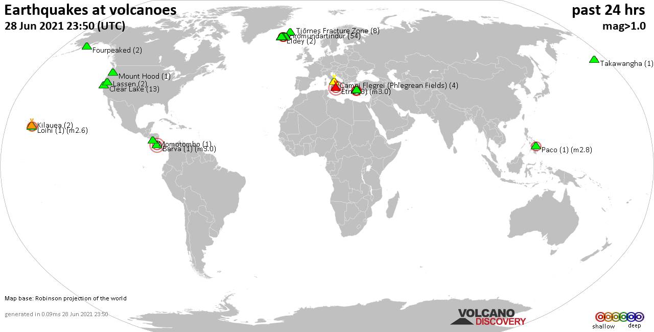
Mon, 5 Jul 2021, 23:50
Volcano earthquake report for Monday, 5 Jul 2021

Quakes detected near: Clear Lake (22 quakes between mag 0.4-1.9), Coso (9 quakes between mag 0.4-1.3), Etna (1 quake mag 3.0), Fourpeaked (1 quake mag 1.5), Furnas (1 quake mag 2.3), Hrómundartindur (3 quakes between mag 0.7-1.5) ... Read all
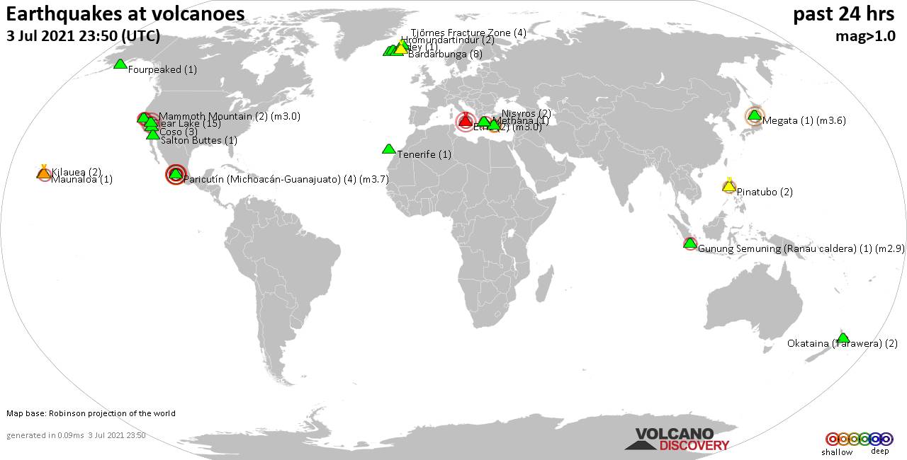
Sun, 4 Jul 2021, 23:50
Volcano earthquake report for Sunday, 4 Jul 2021
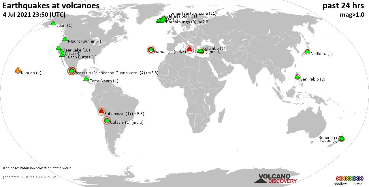
Quakes detected near: Bardarbunga (8 quakes between mag 0.1-2.9), Cerro Negro (1 quake mag 1.4), Clear Lake (16 quakes between mag 0.2-1.7), Colachi (1 quake mag 3.3), Coso (8 quakes between mag 0.6-1.6), Eldey (5 quakes between mag 0.6-1.4) ... Read all
Show more