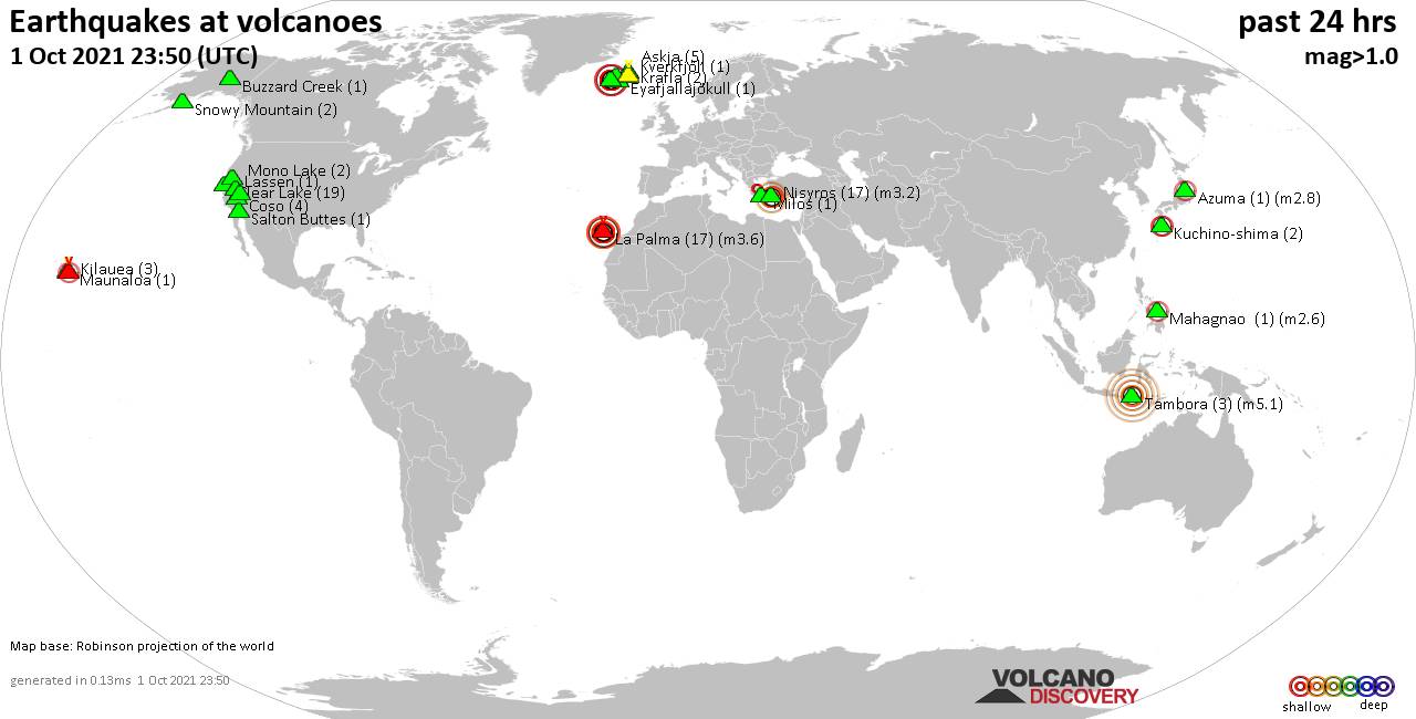
Volcano earthquake report for Saturday, 9 Oct 2021
Sat, 9 Oct 2021, 23:50 | BY: EARTHQUAKEMONITOR
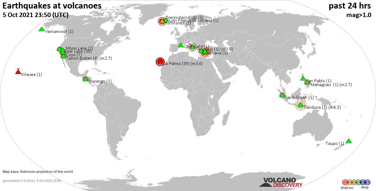
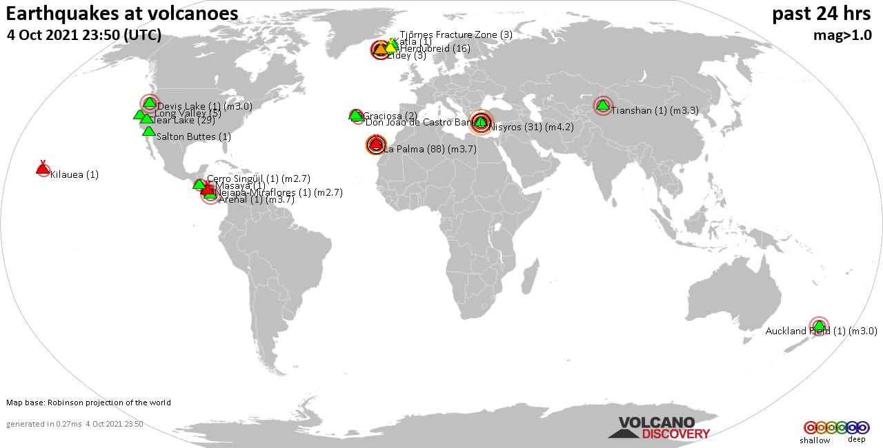
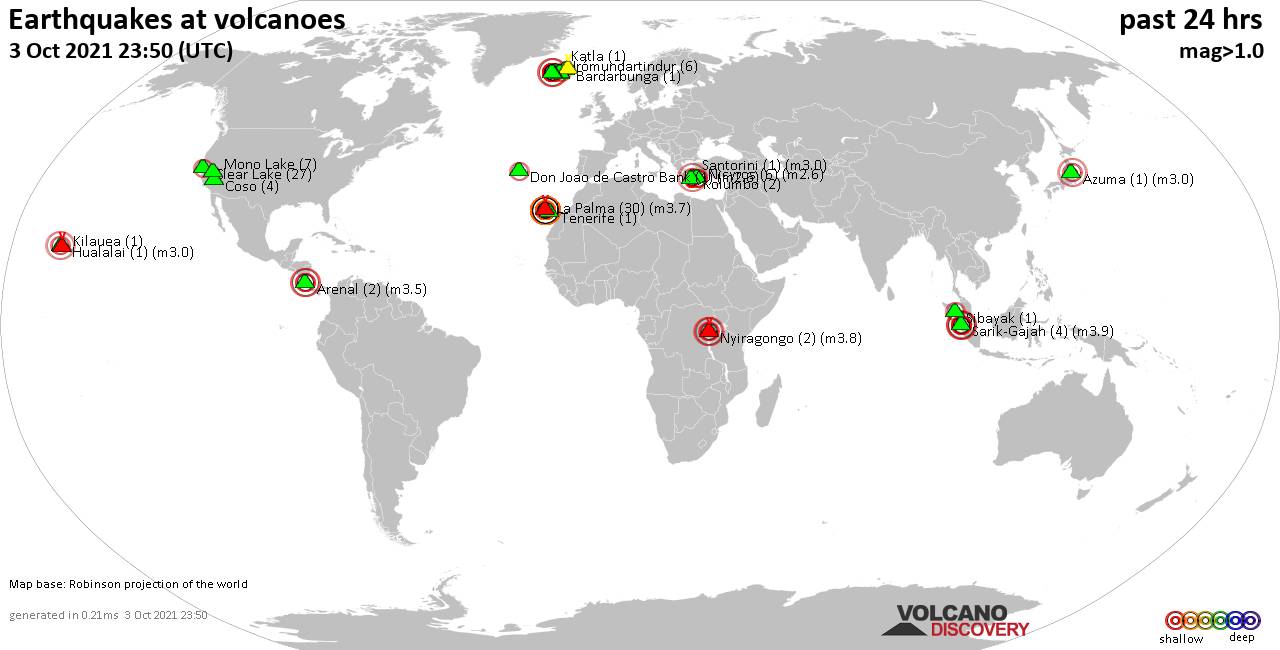
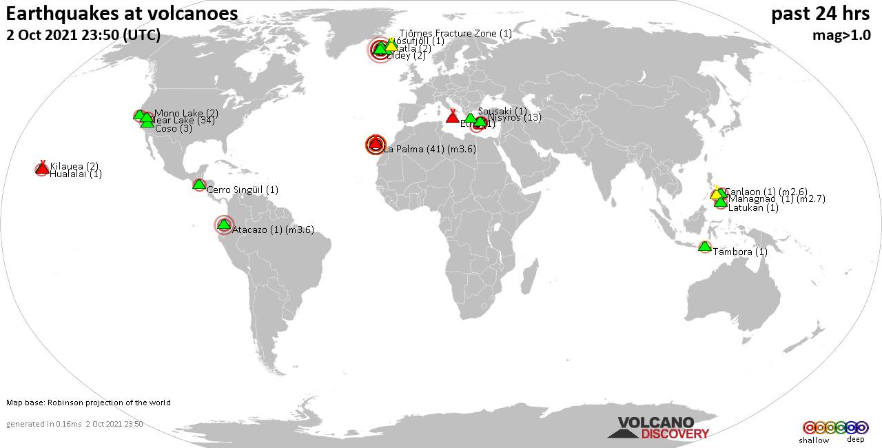
World map showing volcanoes with shallow (less than 20 km) earthquakes within 20 km radius during the past 24 hours on 9 Oct 2021 Number in brackets indicate nr of quakes.
Eldey (1 quake mag 1.3), Fagradalsfjall (12 quakes between mag 0.1-2.2), Herdubreid (8 quakes between mag 0.2-1.1), Hrómundartindur (1 quake mag 1.2), Krísuvík (90 quakes between mag 0.1-2.7), La Palma (129 quakes between mag 2.2-3.6), Mammoth Mountain (2 quakes between mag 1.0-1.5), Mayotte Island (2 quakes between mag 1.9-2.0), Mono Lake (4 quakes between mag 1.2-1.7), Mt Fuji (1 quake mag 3.1), Nisyros (8 quakes between mag 1.4-2.9), Okataina (Tarawera) (1 quake mag 1.9), Orosí (1 quake mag 2.5), Reykjanes (4 quakes between mag 0.5-2.3), Sabancaya (10 quakes between mag 3.5-5.5), Sahand (1 quake mag 2.5), Sarik-Gajah (1 quake mag 2.7), Sousaki (1 quake mag 2.4), Süphan Dağ (1 quake mag 1.9), Tjörnes Fracture Zone (1 quake mag 1.2), Vesuvius (1 quake mag 1.2) (updated 23h50)
Note: Earthquakes within 20 km from and at depths less than 20 km under active volcanoes are reported. The list is not complete because many volcanoes are not monitored and/or seismic data in high resolution is not available publicly.
Volcanoes with recent earthquakes above magnitude 2 or more than 10 quakes are listed below:
Askja volcano (Iceland): 3 earthquakes up to magnitude 3.0
3 earthquakes occurred near (under) the volcano during 7 hours, the last being recorded quake 15 hours ago. Hypocenter depths ranged between 4.9 and 2.6 km.Earthquake details:
3.0 quake Iceland: 6.5 Km S of Lokatindur Oct 9, 2021 8:23 am (GMT +0) (8 km NW)
0.7 quake Iceland: 4.2 Km W of Dreki Oct 9, 2021 2:07 am (GMT +0) (3 km ENE)
0.6 quake Iceland: 5.1 Km WSW of Dreki Oct 9, 2021 1:21 am (GMT +0) (3 km ESE)
All earthquakes at Askja
Clear Lake volcano (California): 27 earthquakes up to magnitude 1.6
Possible earthquake swarm: 27 earthquakes occurred near (under) the volcano during 22 hours, the last being recorded quake 49 minutes ago. Hypocenter depths ranged between 2.7 and 0.5 km.Earthquake details: (only 5 largest)
1.6 quake 9km WNW of The Geysers, CA, Oct 8, 2021 7:28 pm (GMT -7) (18 km SSW)
1.4 quake 6km WNW of Cobb, CA, Oct 9, 2021 12:11 pm (GMT -7) (15 km S)
1.2 quake 8km NW of The Geysers, CA, Oct 9, 2021 2:24 pm (GMT -7) (16 km SSW)
1.1 quake 8km NW of The Geysers, CA, Oct 8, 2021 7:38 pm (GMT -7) (16 km SSW)
1.1 quake 3km W of Cobb, CA, Oct 9, 2021 12:43 am (GMT -7) (16 km S)
All earthquakes at Clear Lake
Fagradalsfjall volcano (Reykjanes Peninsula, Iceland): 12 earthquakes up to magnitude 2.2
Possible earthquake swarm: 12 earthquakes occurred near (under) the volcano during 14 hours, the last being recorded quake 9 hours ago. Hypocenter depths ranged between 8.1 and 1.1 km.Earthquake details: (only 5 largest)
2.2 quake Iceland: 3.4 Km SSW of Keilir Oct 9, 2021 2:26 pm (GMT +0) (4 km NE)
1.7 quake Iceland: 3.5 Km ENE of Fagradalsfjall Oct 9, 2021 2:21 pm (GMT +0) (4 km NE)
1.4 quake Iceland: 3.4 Km SSW of Keilir Oct 9, 2021 12:23 am (GMT +0) (4 km NE)
1.2 quake Iceland: 3.5 Km ENE of Fagradalsfjall Oct 9, 2021 2:24 pm (GMT +0) (4 km NE)
1.2 quake Iceland: 3.2 Km SSW of Keilir Oct 9, 2021 2:26 pm (GMT +0) (4 km NE)
All earthquakes at Fagradalsfjall
Krísuvík volcano (Reykjanes Peninsula, Iceland): 90 earthquakes up to magnitude 2.7
Possible earthquake swarm: 90 earthquakes occurred near (under) the volcano during 17 hours, the last being recorded quake 7 hours ago. Hypocenter depths ranged between 8.6 and 2.2 km.Earthquake details: (only 5 largest)
2.7 quake Iceland: 2.0 Km SSW of Keilir Oct 9, 2021 1:10 pm (GMT +0) (4 km W)
2.1 quake Iceland: 1.8 Km SW of Keilir Oct 9, 2021 7:51 am (GMT +0) (5 km W)
2.1 quake Iceland: 1.6 Km SW of Keilir Oct 9, 2021 1:20 pm (GMT +0) (5 km W)
2.0 quake Iceland: 2.0 Km SSW of Keilir Oct 9, 2021 7:07 am (GMT +0) (4 km W)
1.9 quake Iceland: 1.6 Km SSW of Keilir Oct 9, 2021 9:05 am (GMT +0) (4 km W)
All earthquakes at Krísuvík
La Palma volcano (Canary Islands): 129 earthquakes up to magnitude 3.6
Possible earthquake swarm: 129 earthquakes occurred near (under) the volcano during 23 hours, the last being recorded quake 17 minutes ago. Hypocenter depths ranged between 18.0 and 8.0 km.Earthquake details: (only 5 largest)
3.6 quake La Palma Island, 13 km southeast of Los Llanos de Aridane, Spain, Oct 9, 2021 3:39 pm (GMT +1) (3 km SSE)
3.6 quake La Palma Island, 14 km southeast of Los Llanos de Aridane, Spain, Oct 9, 2021 9:54 pm (GMT +1) (3 km SSE)
3.6 quake La Palma Island, 14 km southeast of Los Llanos de Aridane, Spain, Oct 9, 2021 4:31 pm (GMT +1) (2 km S)
3.6 quake La Palma Island, 13 km southeast of Los Llanos de Aridane, Spain, Oct 9, 2021 11:33 am (GMT +1) (3 km S)
3.5 quake La Palma Island, 12 km southeast of Los Llanos de Aridane, Spain, Oct 9, 2021 6:30 pm (GMT +1) (2 km SSW)
All earthquakes at La Palma
Mt Fuji volcano (Honshu): magnitude 3.1 earthquake
A magnitude 3.1 earthquake occurred at the volcano 15 hours ago. The quake, which might be volcanic in origin, was located at a depth of 9.5 km depth at 11 km distance ESE from the volcano.Earthquake details:
3.1 quake 9.8 km west of Gotenba, Shizuoka, Japan, Oct 9, 2021 5:59 pm (GMT +9) (11 km ESE)
All earthquakes at Mt Fuji
Nisyros volcano (Greece): 8 earthquakes up to magnitude 2.9
8 earthquakes occurred near (under) the volcano during 23 hours, the last being recorded quake 46 minutes ago. Hypocenter depths ranged between 16.1 and 4.3 km.Earthquake details: (only 5 largest)
2.9 quake Aegean Sea, 44 km south of Kos, Dodecanese, South Aegean, Greece, Oct 10, 2021 12:44 am (GMT +3) (8 km SSW)
2.3 quake Aegean Sea, 48 km south of Kos, Dodecanese, South Aegean, Greece, Oct 9, 2021 9:56 pm (GMT +3) (7 km SSW)
2.3 quake Aegean Sea, 47 km south of Kos, Dodecanese, South Aegean, Greece, Oct 9, 2021 9:26 pm (GMT +3) (8 km S)
2.2 quake Aegean Sea, 47 km south of Kos, Dodecanese, South Aegean, Greece, Oct 9, 2021 2:40 pm (GMT +3) (12 km SSE)
1.9 quake Aegean Sea, 45 km south of Kos, Dodecanese, South Aegean, Greece, Oct 10, 2021 2:03 am (GMT +3) (10 km SSW)
All earthquakes at Nisyros
Orosí volcano (Costa Rica): magnitude 2.5 earthquake
A magnitude 2.5 earthquake occurred at the volcano 9 hours ago. The quake, which might be volcanic in origin, was located at a depth of 10.0 km depth at 8 km distance S from the volcano.Earthquake details:
2.5 quake 31 km north of Liberia, Provincia de Guanacaste, Costa Rica, Oct 9, 2021 8:41 am (GMT -6) (8 km S)
All earthquakes at Orosí
Reykjanes volcano (Reykjanes Peninsula, Iceland): 4 earthquakes up to magnitude 2.3
4 earthquakes occurred near (under) the volcano during 6 hours, the last being recorded quake 16 hours ago. Hypocenter depths ranged between 6.0 and 3.6 km.Earthquake details:
2.3 quake Iceland: 2.9 Km NW of Reykjanestá Oct 9, 2021 6:43 am (GMT +0) (14 km SW)
2.2 quake Iceland: 3.3 Km NW of Reykjanestá Oct 9, 2021 1:56 am (GMT +0) (14 km SW)
0.9 quake Iceland: 3.3 Km NW of Reykjanestá Oct 9, 2021 1:57 am (GMT +0) (14 km SW)
0.5 quake Iceland: 4.5 Km NNW of Reykjanestá Oct 9, 2021 7:45 am (GMT +0) (13 km WSW)
All earthquakes at Reykjanes
Sabancaya volcano (Peru): 10 earthquakes up to magnitude 5.5
10 earthquakes occurred near (under) the volcano during 13 hours, the last being recorded quake 6 hours ago. Hypocenter depths ranged between 13.0 and 8.0 km.Earthquake details: (only 5 largest)
5.5 quake Provincia de Caylloma, 84 km northwest of Arequipa, Peru, Oct 8, 2021 11:47 pm (GMT -5) (8 km N)
4.6 quake Provincia de Caylloma, 88 km northwest of Arequipa, Peru, Oct 9, 2021 12:55 pm (GMT -5) (12 km NNE)
4.5 quake 39 km south of Orcopampa, Provincia de Castilla, Arequipa, Peru, Oct 9, 2021 9:31 am (GMT -5) (10 km WNW)
4.3 quake 37 km east of Coracora, Provincia de Parinacochas, Ayacucho, Peru, Oct 9, 2021 8:23 am (GMT -5) (13 km WNW)
4.0 quake Provincia de Caylloma, 88 km northwest of Arequipa, Peru, Oct 9, 2021 2:41 am (GMT -5) (11 km N)
All earthquakes at Sabancaya
Sahand volcano (Iran): magnitude 2.5 earthquake
A magnitude 2.5 earthquake occurred at the volcano 21 hours ago. The quake, which might be volcanic in origin, was located at a depth of 10.0 km depth at 12 km distance WSW from the volcano.Earthquake details:
2.5 quake 42 km south of Tabriz, East Azerbaijan, Iran, Oct 9, 2021 6:23 am (GMT +3:30) (12 km WSW)
All earthquakes at Sahand
Sarik-Gajah volcano (Sumatra): magnitude 2.7 earthquake
A magnitude 2.7 earthquake occurred at the volcano 10 hours ago. The quake, which might be volcanic in origin, was located at a depth of 10.0 km depth at 9 km distance SW from the volcano.Earthquake details:
2.7 quake 45 km northwest of Bukittinggi, Sumatra Barat, Indonesia, Oct 9, 2021 9:01 pm (GMT +7) (9 km SW)
All earthquakes at Sarik-Gajah
Sousaki volcano (Greece): magnitude 2.4 earthquake
A magnitude 2.4 earthquake occurred at the volcano 9 hours ago. The quake, which might be volcanic in origin, was located at a depth of 10.5 km depth at 10 km distance WSW from the volcano.Earthquake details:
2.4 quake 6.2 km south of Corinto, Corinthia, Peloponnese, Greece, Oct 9, 2021 5:45 pm (GMT +3) (10 km WSW)
All earthquakes at Sousaki
Previous news
Fri, 8 Oct 2021, 23:50
Volcano earthquake report for Friday, 8 Oct 2021
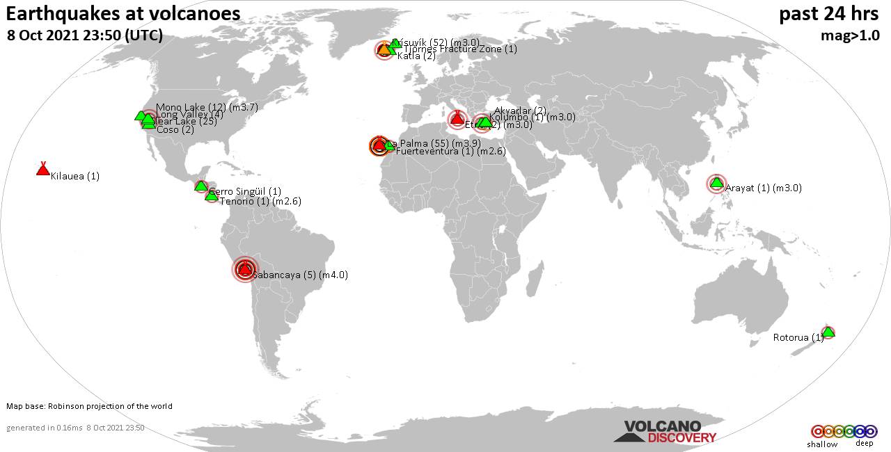
Quakes detected near: Akyarlar (2 quakes between mag 1.2-1.8), Arayat (1 quake mag 3.0), Cerro Singüil (1 quake mag 2.1), Clear Lake (25 quakes between mag 0.4-1.9), Coso (2 quakes between mag 1.2-1.2), Etna (2 quakes between mag 1.3-3.0) ... Read all
Thu, 7 Oct 2021, 23:50
Volcano earthquake report for Thursday, 7 Oct 2021
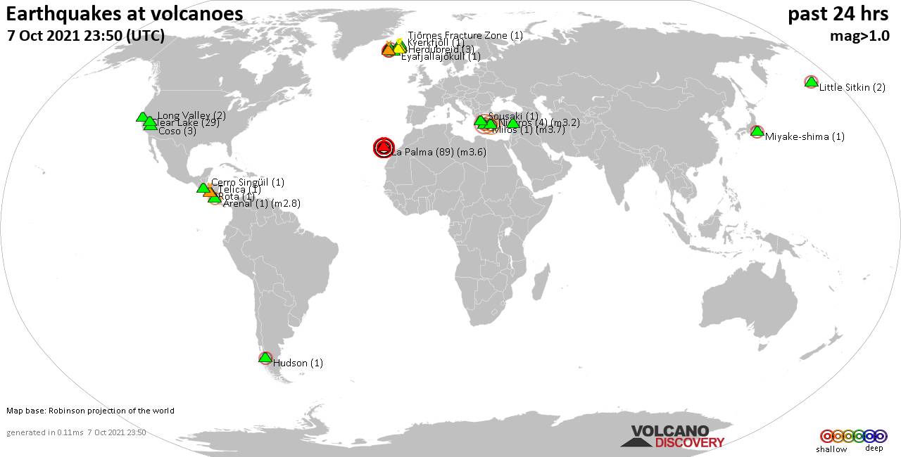
Quakes detected near: Arenal (1 quake mag 2.8), Askja (1 quake mag 1.1), Cerro Singüil (1 quake mag 1.9), Clear Lake (29 quakes between mag 0.2-1.9), Coso (3 quakes between mag 0.7-1.1), Eyafjallajökull (1 quake mag 1.6) ... Read all
Show more