Volcano earthquake report for Wednesday, 13 Oct 2021
Wed, 13 Oct 2021, 23:50 | BY: EARTHQUAKEMONITOR
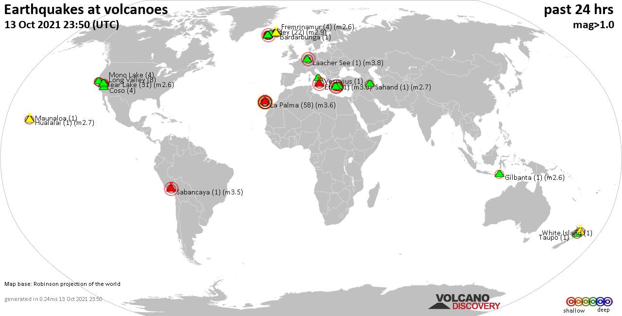
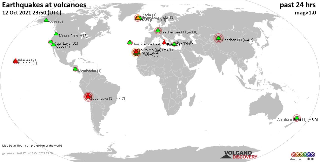
World map showing volcanoes with shallow (less than 20 km) earthquakes within 20 km radius during the past 24 hours on 13 Oct 2021 Number in brackets indicate nr of quakes.
Fremrinamur (4 quakes between mag 1.5-2.6), Gilbanta (1 quake mag 2.6), Herdubreid (17 quakes between mag 0.5-1.5), Hualalai (1 quake mag 2.7), Kolumbo (1 quake mag 3.1), Krísuvík (32 quakes between mag 0.2-3.0), La Palma (58 quakes between mag 2.3-3.6), Laacher See (1 quake mag 3.8), Long Valley (8 quakes between mag 0.2-2.1), Maunaloa (1 quake mag 1.7), Mono Lake (4 quakes between mag 1.3-2.1), Nisyros (6 quakes between mag 1.3-2.8), Prestahnukur (1 quake mag 1.1), Reykjanes (2 quakes between mag 0.9-1.3), Sabancaya (1 quake mag 3.5), Sahand (1 quake mag 2.7), Santorini (1 quake mag 3.0), Taupo (1 quake mag 2.0), Vesuvius (1 quake mag 1.5), White Island (1 quake mag 2.3) (updated 23h50)
Note: Earthquakes within 20 km from and at depths less than 20 km under active volcanoes are reported. The list is not complete because many volcanoes are not monitored and/or seismic data in high resolution is not available publicly.
Volcanoes with recent earthquakes above magnitude 2 or more than 10 quakes are listed below:
Clear Lake volcano (California): 31 earthquakes up to magnitude 2.6
Possible earthquake swarm: 31 earthquakes occurred near (under) the volcano during 23 hours, the last being recorded quake 46 minutes ago. Hypocenter depths ranged between 3.1 and 0.4 km.Earthquake details: (only 5 largest)
2.6 quake 6km NW of The Geysers, CA, Oct 13, 2021 2:41 pm (GMT -7) (18 km S)
2.3 quake 5km NW of The Geysers, CA, Oct 13, 2021 2:27 am (GMT -7) (18 km S)
1.5 quake 8km NW of The Geysers, CA, Oct 13, 2021 9:15 am (GMT -7) (16 km SSW)
1.2 quake 5km NW of Cobb, CA, Oct 13, 2021 10:16 am (GMT -7) (13 km S)
1.2 quake 11km WNW of The Geysers, CA, Oct 13, 2021 7:48 am (GMT -7) (18 km SSW)
All earthquakes at Clear Lake
Eldey volcano (Iceland): 22 earthquakes up to magnitude 2.9
Possible earthquake swarm: 22 earthquakes occurred near (under) the volcano during 6 hours, the last being recorded quake 17 hours ago. Hypocenter depths ranged between 10.3 and 3.8 km.Earthquake details: (only 5 largest)
2.9 quake Iceland: 7.1 Km W of Reykjanestá Oct 13, 2021 3:34 am (GMT +0) (10 km NE)
1.9 quake Iceland: 7.2 Km W of Reykjanestá Oct 13, 2021 12:55 am (GMT +0) (11 km NE)
1.8 quake Iceland: 6.8 Km W of Reykjanestá Oct 13, 2021 3:40 am (GMT +0) (12 km NE)
1.8 quake Iceland: 5.8 Km WNW of Reykjanestá Oct 13, 2021 6:21 am (GMT +0) (12 km NE)
1.8 quake Iceland: 7.2 Km W of Reykjanestá Oct 13, 2021 1:16 am (GMT +0) (11 km NE)
All earthquakes at Eldey
Eldey is located at the beginning of the Reykjanes Ridge off the SW tip of Iceland. Its highest elevation is the top of Eldey Island, but most of the volcanic edifice is submerged.
Several eruptions occurred in historic times, last in 1926.
Etna volcano (Italy): magnitude 3.0 earthquake
A magnitude 3.0 earthquake occurred at the volcano 21 hours ago. The quake, which might be volcanic in origin, was located at a depth of 10.0 km depth at 0 km distance SW from the volcano.Earthquake details:
Reported seismic-like event (likely no quake): 30 km north of Catania, Sicily, Italy, Oct 13, 2021 5:00 am (GMT +2) (0 km SW)
All earthquakes at Etna
Fremrinamur volcano (Iceland): 4 earthquakes up to magnitude 2.6
4 earthquakes occurred near (under) the volcano during 5 minutes, the last being recorded quake 16 hours ago. Hypocenter depths ranged between 1.8 and 0.0 km.Earthquake details:
2.6 quake Iceland: 5.1 Km NW of Herðubreiðarfjöll Oct 13, 2021 8:02 am (GMT +0) (10 km SSE)
1.8 quake Iceland: 6.0 Km WNW of Herðubreiðarfjöll Oct 13, 2021 8:03 am (GMT +0) (10 km SSE)
1.8 quake Iceland: 5.8 Km WNW of Herðubreiðarfjöll Oct 13, 2021 7:58 am (GMT +0) (10 km SSE)
1.5 quake Iceland: 6.4 Km WNW of Herðubreiðarfjöll Oct 13, 2021 8:03 am (GMT +0) (10 km SSE)
All earthquakes at Fremrinamur
Gilbanta volcano (Lesser Sunda Islands): magnitude 2.6 earthquake
A magnitude 2.6 earthquake occurred at the volcano 5 hours ago. The quake, which might be volcanic in origin, was located at a depth of 13.0 km depth at 7 km distance N from the volcano.Earthquake details:
2.6 quake Flores Sea, 65 km west of Labuan Bajo, East Nusa Tenggara, Indonesia, Oct 14, 2021 2:52 am (GMT +8) (7 km N)
All earthquakes at Gilbanta
Herdubreid volcano (Iceland): 17 earthquakes up to magnitude 1.5
Possible earthquake swarm: 17 earthquakes occurred near (under) the volcano during 8 hours, the last being recorded quake 6 hours ago. Hypocenter depths ranged between 9.8 and 3.0 km.Earthquake details: (only 5 largest)
1.5 quake Iceland: 3.9 Km S of Herðubreið Oct 13, 2021 2:18 pm (GMT +0) (4 km S)
1.2 quake Iceland: 4.6 Km N of Herðubreiðartögl Oct 13, 2021 2:18 pm (GMT +0) (6 km SSW)
1.1 quake Iceland: 4.4 Km NNE of Herðubreiðartögl Oct 13, 2021 3:49 pm (GMT +0) (6 km S)
1.0 quake Iceland: 3.6 Km S of Herðubreið Oct 13, 2021 4:26 pm (GMT +0) (4 km S)
1.0 quake Iceland: 3.3 Km S of Herðubreið Oct 13, 2021 1:58 pm (GMT +0) (4 km S)
All earthquakes at Herdubreid
Hualalai volcano (Hawai'i (Big Island)): magnitude 2.7 earthquake
A magnitude 2.7 earthquake occurred at the volcano 3 hours ago. The quake, which might be volcanic in origin, was located at a depth of 6.7 km depth at 18 km distance WSW from the volcano.Earthquake details:
2.7 quake North Pacific Ocean, 2.3 mi southwest of Kailua-Kona, Hawaii County, USA, Oct 13, 2021 10:42 am (GMT -10) (18 km WSW)
All earthquakes at Hualalai
Kolumbo volcano (Greece): magnitude 3.1 earthquake
A magnitude 3.1 earthquake occurred at the volcano 13 hours ago. The quake, which might be volcanic in origin, was located at a depth of 7.0 km depth at 13 km distance NE from the volcano.Earthquake details:
3.1 quake Aegean Sea, Greece, Oct 13, 2021 2:00 pm (GMT +3) (13 km NE)
All earthquakes at Kolumbo
Krísuvík volcano (Reykjanes Peninsula, Iceland): 32 earthquakes up to magnitude 3.0
Possible earthquake swarm: 32 earthquakes occurred near (under) the volcano during 21 hours, the last being recorded quake 2 hours ago. Hypocenter depths ranged between 7.2 and 1.5 km.Earthquake details: (only 5 largest)
3.0 quake Iceland: 1.9 Km SW of Keilir Oct 13, 2021 2:23 am (GMT +0) (5 km W)
2.3 quake Iceland: 2.0 Km SSW of Keilir Oct 13, 2021 9:49 pm (GMT +0) (4 km W)
2.3 quake Iceland: 1.9 Km SW of Keilir Oct 13, 2021 9:23 pm (GMT +0) (5 km W)
2.2 quake Iceland: 1.9 Km SSW of Keilir Oct 13, 2021 2:06 am (GMT +0) (4 km W)
2.1 quake Iceland: 1.6 Km SW of Keilir Oct 13, 2021 2:42 am (GMT +0) (5 km W)
All earthquakes at Krísuvík
La Palma volcano (Canary Islands): 58 earthquakes up to magnitude 3.6
Possible earthquake swarm: 58 earthquakes occurred near (under) the volcano during 23 hours, the last being recorded quake 23 minutes ago. Hypocenter depths ranged between 15.0 and 10.0 km.Earthquake details: (only 5 largest)
3.6 quake La Palma Island, Canary Islands, Spain, Oct 13, 2021 10:37 am (GMT +1) (2 km S)
3.5 quake La Palma Island, Canary Islands, Spain, Oct 13, 2021 4:35 am (GMT +1) (3 km SSE)
3.4 quake La Palma Island, Canary Islands, Spain, Oct 13, 2021 11:15 pm (GMT +1) (3 km ESE)
3.4 quake La Palma Island, Canary Islands, Spain, Oct 13, 2021 5:17 pm (GMT +1) (1 km SE)
3.3 quake La Palma Island, Canary Islands, Spain, Oct 13, 2021 1:22 pm (GMT +1) (2 km S)
All earthquakes at La Palma
Laacher See volcano (Germany): magnitude 3.8 earthquake
A magnitude 3.8 earthquake occurred at the volcano 8 hours ago. The quake, which might be volcanic in origin, was located at a depth of 10.0 km depth at 17 km distance NE from the volcano.Earthquake details:
Unconfirmed earthquake or seismic-like event: Regierungsbezirk Arnsberg, North Rhine-Westphalia, Germany, Oct 13, 2021 5:32 pm (GMT +2) (17 km NE)
All earthquakes at Laacher See
Long Valley volcano (California): 8 earthquakes up to magnitude 2.1
8 earthquakes occurred near (under) the volcano during 16 hours, the last being recorded quake 3 hours ago. Hypocenter depths ranged between 7.9 and 6.1 km.Earthquake details: (only 5 largest)
2.1 quake 12km W of Toms Place, CA, Oct 12, 2021 11:36 pm (GMT -7) (17 km SSE)
2.0 quake 12km W of Toms Place, CA, Oct 12, 2021 10:05 pm (GMT -7) (17 km SSE)
1.2 quake 12km W of Toms Place, CA, Oct 13, 2021 1:33 pm (GMT -7) (18 km SSE)
0.9 quake 12km W of Toms Place, CA, Oct 12, 2021 9:11 pm (GMT -7) (17 km SSE)
0.7 quake 12km W of Toms Place, CA, Oct 13, 2021 12:10 am (GMT -7) (17 km SSE)
All earthquakes at Long Valley
Mono Lake volcano (California): 4 earthquakes up to magnitude 2.1
4 earthquakes occurred near (under) the volcano during 3 hours, the last being recorded quake 5 hours ago. Hypocenter depths ranged between 9.8 and 0.0 km.Earthquake details:
2.1 quake 13km SSE of Bodie, CA, Oct 13, 2021 11:21 am (GMT -7) (14 km NNE)
1.8 quake California-Nevada Border Region Oct 13, 2021 9:32 am (GMT -7) (13 km NNE)
1.3 quake 17 Km ENE of Mono City, California, Oct 13, 2021 9:46 am (GMT -7) (11 km NNE)
1.3 quake 18 Km ENE of Mono City, California, Oct 13, 2021 8:30 am (GMT -7) (13 km NNE)
All earthquakes at Mono Lake
Nisyros volcano (Greece): 6 earthquakes up to magnitude 2.8
6 earthquakes occurred near (under) the volcano during 20 hours, the last being recorded quake 3 hours ago. Hypocenter depths ranged between 14.9 and 5.0 km.Earthquake details: (only 5 largest)
2.8 quake Aegean Sea, Greece, Oct 13, 2021 7:06 am (GMT +3) (11 km SSW)
2.5 quake Aegean Sea, Greece, Oct 13, 2021 1:46 pm (GMT +3) (6 km S)
2.1 quake Aegean Sea, Greece, Oct 13, 2021 3:40 am (GMT +3) (10 km S)
1.8 quake Aegean Sea, Greece, Oct 13, 2021 6:26 pm (GMT +3) (17 km SSW)
1.4 quake Greece: ONIKI ADALAR (MEDITERRANEAN SEA) Oct 13, 2021 11:46 pm (GMT +3) (14 km S)
All earthquakes at Nisyros
Sabancaya volcano (Peru): magnitude 3.5 earthquake
A magnitude 3.5 earthquake occurred at the volcano 6 hours ago. The quake, which might be volcanic in origin, was located at a depth of 9.0 km depth at 15 km distance NNW from the volcano.Earthquake details:
3.5 quake Provincia de Caylloma, Arequipa, Peru, Oct 13, 2021 12:30 pm (GMT -5) (15 km NNW)
All earthquakes at Sabancaya
Sahand volcano (Iran): magnitude 2.7 earthquake
A magnitude 2.7 earthquake occurred at the volcano 15 hours ago. The quake, which might be volcanic in origin, was located at a depth of 6.0 km depth at 14 km distance WSW from the volcano.Earthquake details:
2.7 quake 42 km south of Tabriz, East Azerbaijan, Iran, Oct 13, 2021 12:11 pm (GMT +3:30) (14 km WSW)
All earthquakes at Sahand
Santorini volcano (Greece): magnitude 3.0 earthquake
A magnitude 3.0 earthquake occurred at the volcano 20 hours ago. The quake, which might be volcanic in origin, was located at a depth of 10.0 km depth at 9 km distance N from the volcano.Earthquake details:
Reported seismic-like event (likely no quake): Kykladene, South Aegean, Greece, Oct 13, 2021 6:26 am (GMT +3) (9 km N)
All earthquakes at Santorini
White Island volcano (New Zealand): magnitude 2.3 earthquake
A magnitude 2.3 earthquake occurred at the volcano 15 hours ago. The quake, which might be volcanic in origin, was located at a depth of 5.0 km depth at 10 km distance SE from the volcano.Earthquake details:
2.3 quake South Pacific Ocean, New Zealand, Oct 13, 2021 9:37 pm (GMT +13) (10 km SE)
All earthquakes at White Island
Previous news
Tue, 12 Oct 2021, 23:50
Volcano earthquake report for Tuesday, 12 Oct 2021
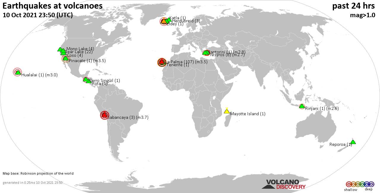
Quakes detected near: Auckland Field (1 quake mag 3.0), Clear Lake (31 quakes between mag 0.3-2.0), Coso (4 quakes between mag 0.8-1.3), Don Joao de Castro Bank (2 quakes between mag 2.5-2.7), El Hierro (1 quake mag 2.5), Eldey (6 quakes between mag 0.2-3.3) ... Read all
Mon, 11 Oct 2021, 23:50
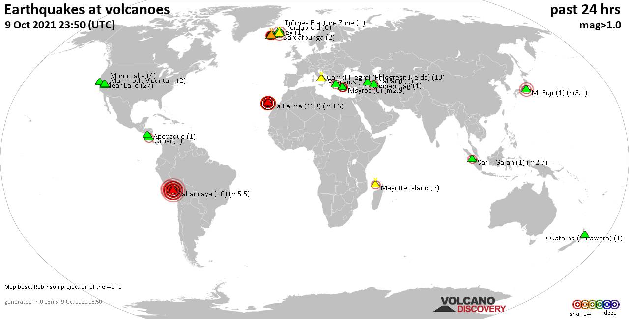
Volcano earthquake report for Monday, 11 Oct 2021

Quakes detected near: Askja (1 quake mag 1.0), Clear Lake (25 quakes between mag 0.1-2.0), Coso (6 quakes between mag 0.2-1.1), Eyafjallajökull (2 quakes between mag 1.5-1.9), Hofsjökull volcano (1 quake mag 1.9), Kilauea (2 quakes between mag 1.7-2.4) ... Read all
Show more