Volcano earthquake report for Sunday, 14 Nov 2021
Sun, 14 Nov 2021, 23:50 | BY: EARTHQUAKEMONITOR
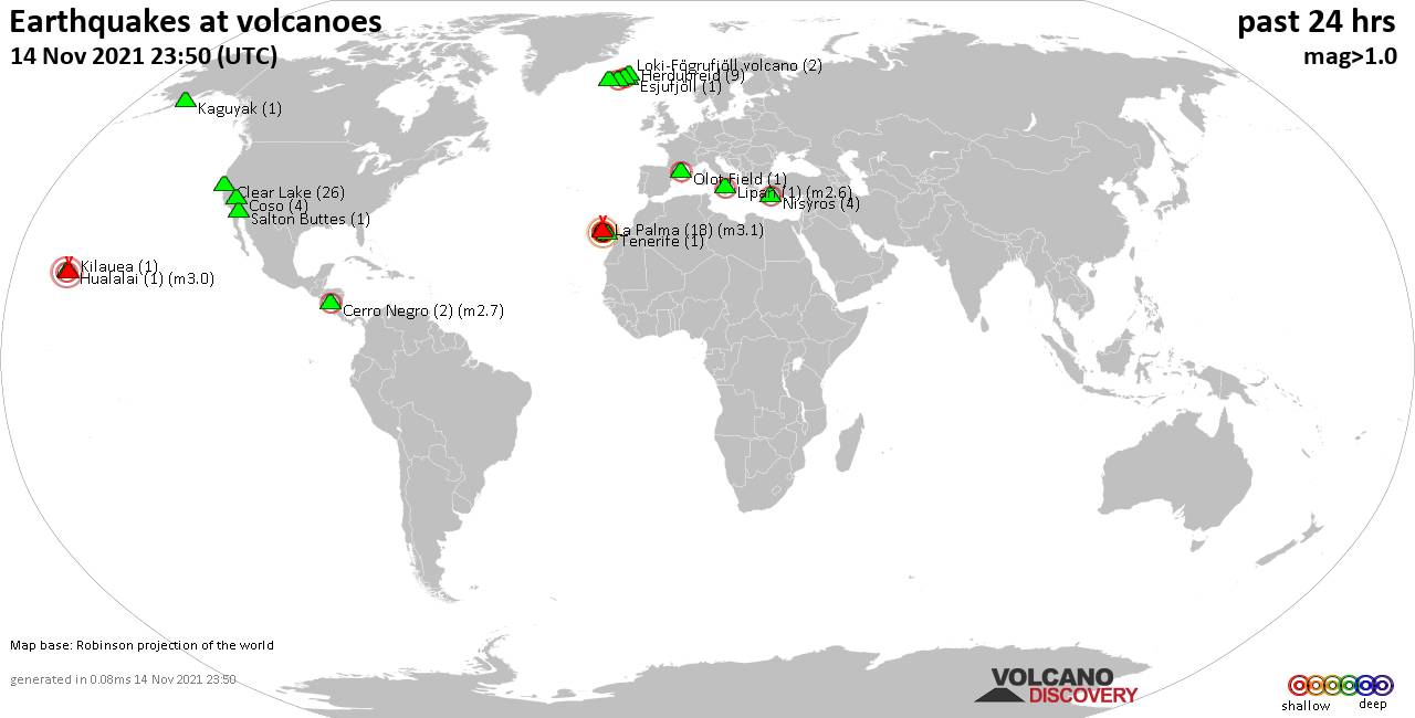
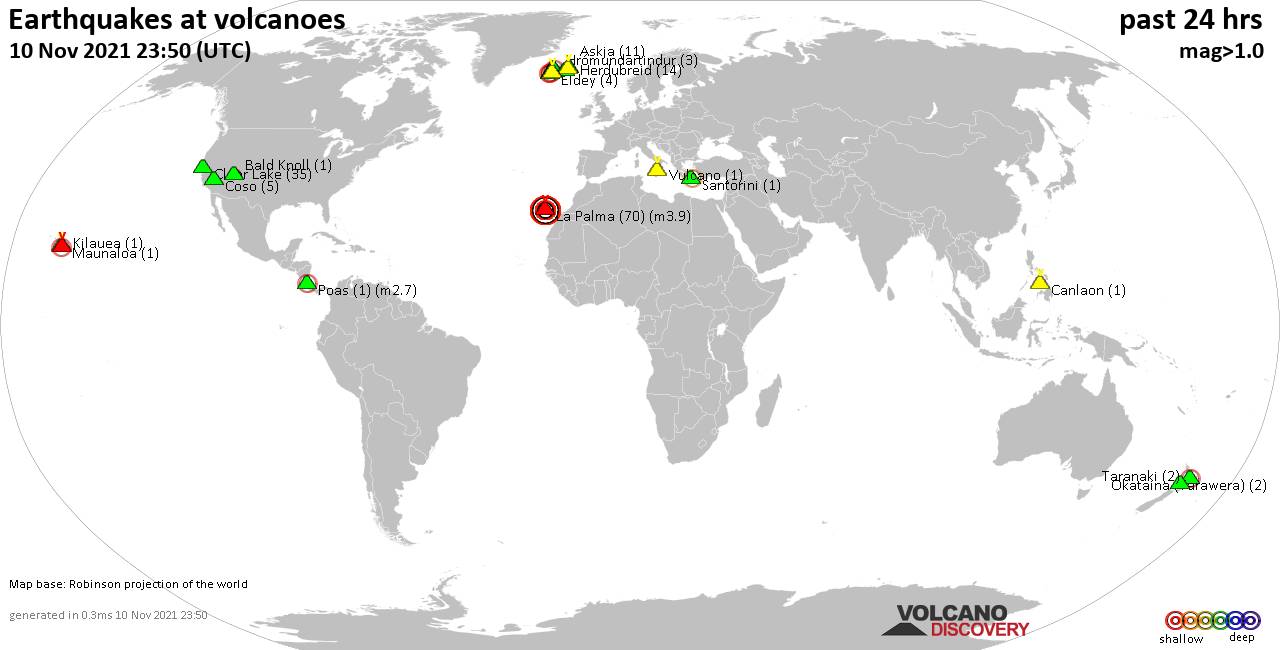
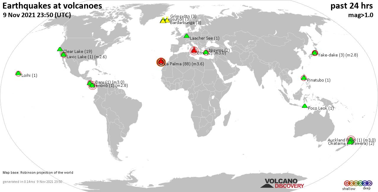
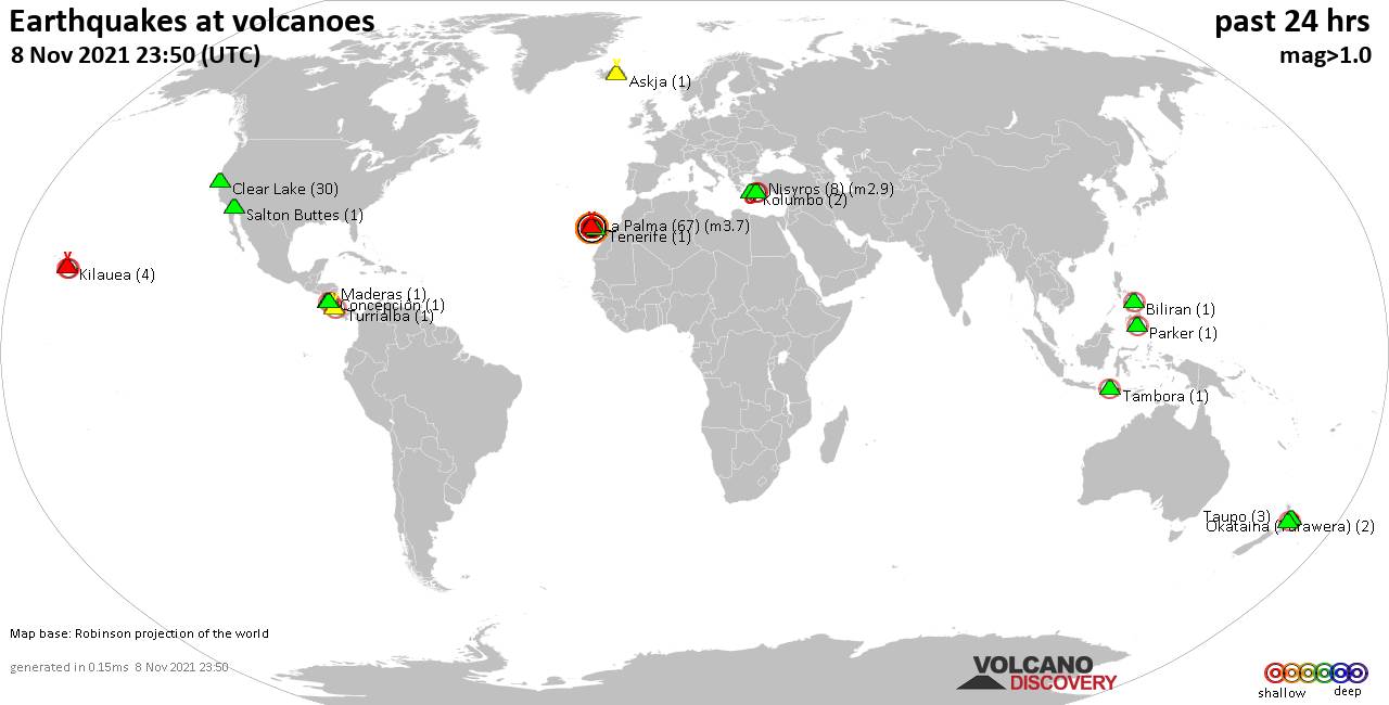
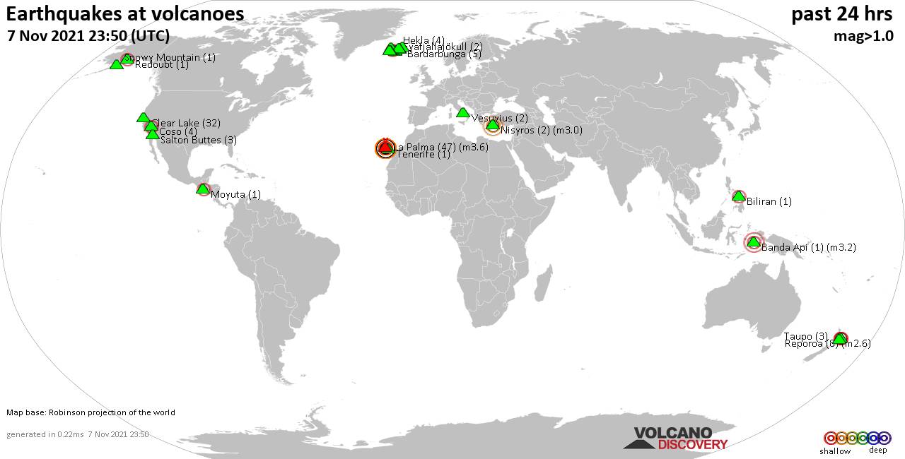
World map showing volcanoes with shallow (less than 20 km) earthquakes within 20 km radius during the past 24 hours on 14 Nov 2021 Number in brackets indicate nr of quakes.
Kaguyak (1 quake mag 1.1), Kilauea (1 quake mag 1.9), La Palma (18 quakes between mag 2.1-3.1), Lipari (1 quake mag 2.6), Loki-Fögrufjöll volcano (2 quakes between mag 0.9-2.0), Nisyros (4 quakes between mag 1.4-2.4), Olot Field (1 quake mag 2.0), Reykjanes (2 quakes between mag 0.8-1.0), Salton Buttes (1 quake mag 1.5), Tenerife (1 quake mag 1.4), Vatnafjöll (24 quakes between mag 0.3-2.0) (updated 23h50)
Note: Earthquakes within 20 km from and at depths less than 20 km under active volcanoes are reported. The list is not complete because many volcanoes are not monitored and/or seismic data in high resolution is not available publicly.
Volcanoes with recent earthquakes above magnitude 2 or more than 10 quakes are listed below:
Cerro Negro volcano (Nicaragua): 2 earthquakes up to magnitude 2.7
2 earthquakes occurred near (under) the volcano during 17 hours, the last being recorded quake 6 hours ago. Hypocenter depths ranged between 10.0 and 8.0 km.Earthquake details:
2.7 quake 17 km east of Leon, Nicaragua, Nov 14, 2021 11:58 am (GMT -6) (4 km WSW)
1.3 quake 2 Km Al Norte De Volcán Cerro Negro, Nicaragua, Nov 13, 2021 7:20 pm (GMT -6) (2 km N)
All earthquakes at Cerro Negro
Clear Lake volcano (California): 26 earthquakes up to magnitude 1.7
Possible earthquake swarm: 26 earthquakes occurred near (under) the volcano during 20 hours, the last being recorded quake 3 hours ago. Hypocenter depths ranged between 3.1 and 0.2 km.Earthquake details: (only 5 largest)
1.7 quake 8km W of Cobb, CA, Nov 14, 2021 1:11 am (GMT -8) (16 km SSW)
1.6 quake 7km W of Cobb, CA, Nov 14, 2021 12:38 am (GMT -8) (16 km S)
1.2 quake 8km W of Cobb, CA, Nov 14, 2021 1:11 am (GMT -8) (16 km SSW)
1.0 quake 2km NNE of The Geysers, CA, Nov 14, 2021 10:25 am (GMT -8) (19 km S)
1.0 quake 8km NW of The Geysers, CA, Nov 13, 2021 5:58 pm (GMT -8) (16 km SSW)
All earthquakes at Clear Lake
Hualalai volcano (Hawai'i (Big Island)): magnitude 3.0 earthquake
A magnitude 3.0 earthquake occurred at the volcano 8 hours ago. The quake, which might be volcanic in origin, was located at a depth of 10.0 km depth at 14 km distance SW from the volcano.Earthquake details:
Reported seismic-like event (likely no quake): 1.6 mi southeast of Kailua-Kona, Hawaii County, USA, Nov 14, 2021 5:28 am (GMT -10) (14 km SW)
All earthquakes at Hualalai
La Palma volcano (Canary Islands): 18 earthquakes up to magnitude 3.1
Possible earthquake swarm: 18 earthquakes occurred near (under) the volcano during 21 hours, the last being recorded quake 3 hours ago. Hypocenter depths ranged between 17.0 and 10.0 km.Earthquake details: (only 5 largest)
3.1 quake La Palma Island, 13 km southeast of Los Llanos de Aridane, Spain, Nov 14, 2021 2:58 am (GMT +0) (5 km SSW)
2.9 quake La Palma Island, 14 km southeast of Los Llanos de Aridane, Spain, Nov 14, 2021 4:41 am (GMT +0) (4 km SSW)
2.9 quake La Palma Island, 14 km southeast of Los Llanos de Aridane, Spain, Nov 14, 2021 4:57 am (GMT +0) (4 km S)
2.7 quake La Palma Island, 15 km southeast of Los Llanos de Aridane, Spain, Nov 14, 2021 11:53 am (GMT +0) (3 km SSE)
2.6 quake La Palma Island, 14 km southeast of Los Llanos de Aridane, Spain, Nov 14, 2021 3:13 pm (GMT +0) (3 km S)
All earthquakes at La Palma
Lipari volcano (Eolian Islands): magnitude 2.6 earthquake
A magnitude 2.6 earthquake occurred at the volcano 8 hours ago. The quake, which might be volcanic in origin, was located at a depth of 10.1 km depth at 8 km distance SW from the volcano.Earthquake details:
2.6 quake Tyrrhenian Sea, 6.9 km west of Lipari, Province of Messina, Sicily, Italy, Nov 14, 2021 4:50 pm (GMT +1) (8 km SW)
All earthquakes at Lipari
Nisyros volcano (Greece): 4 earthquakes up to magnitude 2.4
4 earthquakes occurred near (under) the volcano during 7 hours, the last being recorded quake 1 hour 7 minutes ago. Hypocenter depths ranged between 17.5 and 5.0 km.Earthquake details:
2.4 quake 38 km south of Kos, Dodecanese, South Aegean, Greece, Nov 14, 2021 5:34 pm (GMT +2) (6 km SE)
1.9 quake Aegean Sea, 96 km west of Rhodos, Dodecanese, South Aegean, Greece, Nov 15, 2021 12:38 am (GMT +2) (17 km S)
1.6 quake Aegean Sea, 41 km south of Kos, Dodecanese, South Aegean, Greece, Nov 14, 2021 11:28 pm (GMT +2) (6 km SSE)
1.4 quake Greece: 9 Km SE From Nissiros Nov 15, 2021 12:42 am (GMT +2) (9 km WNW)
All earthquakes at Nisyros
Vatnafjöll volcano (Iceland): 24 earthquakes up to magnitude 2.0
Possible earthquake swarm: 24 earthquakes occurred near (under) the volcano during 23 hours, the last being recorded quake 49 minutes ago. Hypocenter depths ranged between 12.2 and 3.4 km.Earthquake details: (only 5 largest)
2.0 quake Iceland: 1.0 Km WSW of Vatnafjöll Nov 14, 2021 11:07 am (GMT +0) (0 km SSE)
1.6 quake Iceland: 4.9 Km W of Vatnafjöll Nov 14, 2021 5:33 am (GMT +0) (4 km W)
1.6 quake Iceland: 0.5 Km W of Vatnafjöll Nov 14, 2021 6:28 am (GMT +0) (1 km ESE)
1.5 quake Iceland: 0.5 Km E of Vatnafjöll Nov 14, 2021 5:15 am (GMT +0) (2 km E)
1.4 quake Iceland: 1.0 Km S of Vatnafjöll Nov 14, 2021 2:35 am (GMT +0) (1 km SE)
All earthquakes at Vatnafjöll
Previous news
Sat, 13 Nov 2021, 23:50
Volcano earthquake report for Saturday, 13 Nov 2021
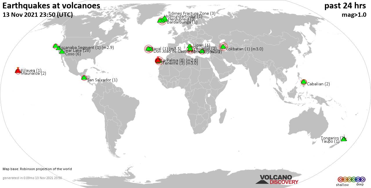
Quakes detected near: Bardarbunga (1 quake mag 1.6), Cabalian (2 quakes between mag 2.2-2.5), Clear Lake (28 quakes between mag 0.4-1.4), Coso (6 quakes between mag 0.5-1.8), Don Joao de Castro Bank (1 quake mag 2.7), Escanaba Segment (1 quake mag 2.9) ... Read all
Fri, 12 Nov 2021, 23:50
Volcano earthquake report for Friday, 12 Nov 2021
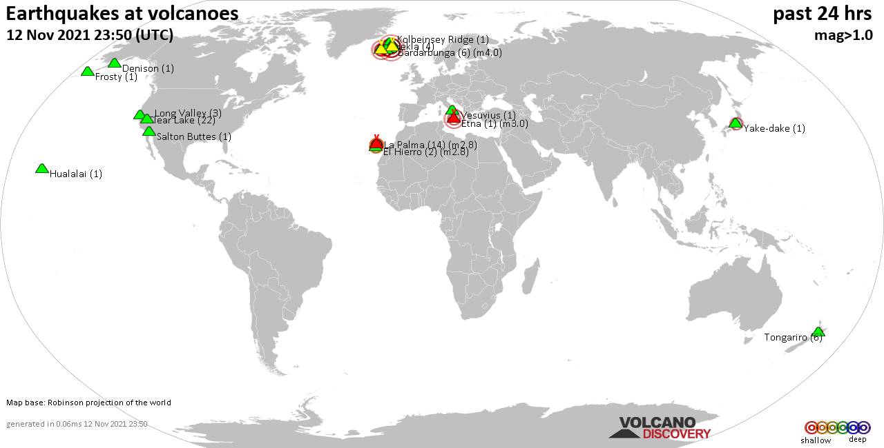
Quakes detected near: Askja (3 quakes between mag 0.1-1.1), Bardarbunga (6 quakes between mag 0.6-4.0), Clear Lake (22 quakes between mag 0.4-1.4), Denison (1 quake mag 1.2), El Hierro (2 quakes between mag 2.5-2.8), Etna (1 quake mag 3.0) ... Read all
Show more