Volcano earthquake report for Wednesday, 10 Jul 2019
Wed, 10 Jul 2019, 23:50 | BY: EARTHQUAKEMONITOR
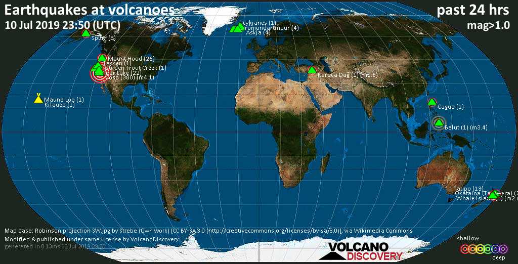
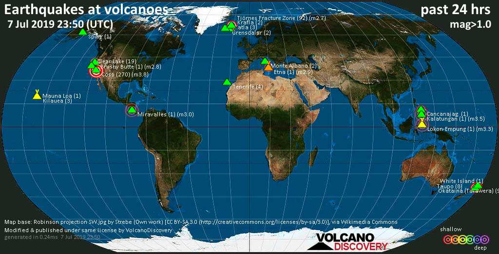
World map showing volcanoes with shallow (less than 20 km) earthquakes within 20 km radius during the past 24 hours on 10 Jul 2019 Number in brackets indicate nr of quakes.
Hrómundartindur (4 quakes between mag 0.1-1.0), Karaca Dağ (1 quake mag 2.6), Kilauea (1 quake mag 1.7), Lassen (1 quake mag 1.1), Mammoth Mountain (3 quakes between mag 0.4-1.3), Mauna Loa (1 quake mag 1.8), Mount Hood (26 quakes between mag 0.2-2.1), Okataina (Tarawera) (2 quakes between mag 1.6-1.7), Reykjanes (1 quake mag 1.3), Ruapehu (1 quake mag 1.1), Spurr (3 quakes between mag 1.2-2.0), Taupo (13 quakes between mag 1.1-2.4), Tjörnes Fracture Zone (2 quakes between mag 0.8-1.3), Tongariro (2 quakes between mag 0.8-2.2), Torfajökull (5 quakes between mag 0.5-1.3), Whale Island (3 quakes between mag 1.8-2.6) (updated 23h50)
Note: Earthquakes within 20 km from and at depths less than 20 km under active volcanoes are reported. The list is not complete because many volcanoes are not monitored and/or seismic data in high resolution is not available publicly.
Volcanoes with recent earthquakes above magnitude 2 or more than 10 quakes are listed below:
Balut volcano (Mindanao): magnitude 3.4 earthquake
A magnitude 3.4 earthquake occurred at the volcano 28 minutes ago. The quake, which might be volcanic in origin, was located at a depth of 14.0 km depth at 10 km distance ESE from the volcano.Earthquake details:
M 3.4 quake: 021 km S 75° W of Sarangani (Davao Occidental) (Philippines) on Wed, 10 Jul 23h22 (10 km ESE)
All earthquakes at Balut
Cagua volcano (Luzon Island): magnitude 2.4 earthquake
A magnitude 2.4 earthquake occurred at the volcano 1 hour 41 minutes ago. The quake, which might be volcanic in origin, was located at a depth of 1.0 km depth at 11 km distance NW from the volcano.Earthquake details:
M 2.4 quake: 018 km S 18° E of Santa Ana (Cagayan) (Philippines) on Wed, 10 Jul 22h09 (11 km NW)
All earthquakes at Cagua
Clear Lake volcano (California): 22 earthquakes up to magnitude 1.6
Possible earthquake swarm: 22 earthquakes occurred near (under) the volcano during 22 hours, the last being recorded quake 2 hours ago. Hypocenter depths ranged between 4.0 and 0.7 km.Earthquake details: (only 5 largest)
M 1.6 quake: 6km NNW of The Geysers, CA (USA) on Wed, 10 Jul 16h52 (16 km S)
M 1.1 quake: 7km WNW of Cobb, CA (USA) on Tue, 9 Jul 23h50 (15 km S)
M 1.1 quake: 6km NW of The Geysers, CA (USA) on Wed, 10 Jul 17h25 (17 km S)
M 1.1 quake: 8km W of Cobb, CA (USA) on Wed, 10 Jul 14h51 (16 km S)
M 1.1 quake: 7km WNW of The Geysers, CA (USA) on Wed, 10 Jul 15h29 (18 km S)
All earthquakes at Clear Lake
Coso volcano (California): 380 earthquakes up to magnitude 4.1
Possible earthquake swarm: 380 earthquakes occurred near (under) the volcano during 24 hours, the last being recorded quake 21 minutes ago. Hypocenter depths ranged between 19.4 and 0.0 km.Earthquake details: (only 5 largest)
M 4.1 quake: 9km E of Coso Junction, CA (USA) on Wed, 10 Jul 00h48 (4 km N)
M 4.1 quake: 14km NNE of Coso Junction, CA (USA) on Wed, 10 Jul 18h49 (16 km N)
M 4.1 quake: 8km E of Coso Junction, CA (USA) on Wed, 10 Jul 12h28 (4 km N)
M 4.0 quake: 20km E of Little Lake, CA (USA) on Wed, 10 Jul 01h43 (18 km SSE)
M 3.9 quake: 15km NNE of Coso Junction, CA (USA) on Wed, 10 Jul 22h15 (17 km N)
All earthquakes at Coso
Karaca Dağ volcano (Turkey): magnitude 2.6 earthquake
A magnitude 2.6 earthquake occurred at the volcano 12 hours ago. The quake, which might be volcanic in origin, was located at a depth of 5.3 km depth at 1 km distance N from the volcano.Earthquake details:
M 2.6 quake: Gazikoy-siverek (sanliurfa) (Turkey) on Wed, 10 Jul 12h05 (1 km N)
All earthquakes at Karaca Dağ
Mount Hood volcano (Oregon): 26 earthquakes up to magnitude 2.1
Possible earthquake swarm: 26 earthquakes occurred near (under) the volcano during 7 hours, the last being recorded quake 16 hours ago. Hypocenter depths ranged between 4.5 and 3.3 km.Earthquake details: (only 5 largest)
M 2.1 quake: 20km ESE of Mount Hood Village, Oregon (USA) on Wed, 10 Jul 04h23 (6 km S)
M 2.0 quake: 19km E of Mount Hood Village, Oregon (USA) on Wed, 10 Jul 04h18 (7 km S)
M 2.0 quake: 20km ESE of Mount Hood Village, Oregon (USA) on Wed, 10 Jul 04h36 (8 km S)
M 1.7 quake: 20km ESE of Mount Hood Village, Oregon (USA) on Wed, 10 Jul 04h10 (6 km S)
M 1.5 quake: 20km ESE of Mount Hood Village, Oregon (USA) on Wed, 10 Jul 04h37 (7 km S)
All earthquakes at Mount Hood
Taupo volcano (New Zealand): 13 earthquakes up to magnitude 2.4
Possible earthquake swarm: 13 earthquakes occurred near (under) the volcano during 18 hours, the last being recorded quake 4 hours ago. Hypocenter depths ranged between 10.4 and 5.0 km.Earthquake details: (only 5 largest)
M 2.4 quake: New Zealand on Wed, 10 Jul 03h39 (13 km ESE)
M 2.3 quake: New Zealand on Wed, 10 Jul 03h05 (12 km E)
M 2.1 quake: New Zealand on Wed, 10 Jul 08h28 (14 km E)
M 2.1 quake: New Zealand on Wed, 10 Jul 03h04 (12 km E)
M 2.0 quake: New Zealand on Wed, 10 Jul 03h29 (14 km E)
All earthquakes at Taupo
Tongariro volcano (North Island): 2 earthquakes up to magnitude 2.2
2 earthquakes occurred near (under) the volcano during 13 hours, the last being recorded quake 7 hours ago. Hypocenter depths ranged between 12.2 and 4.6 km.Earthquake details:
M 2.2 quake: New Zealand on Wed, 10 Jul 03h51 (11 km NNW)
M 0.8 quake: New Zealand on Wed, 10 Jul 16h39 (13 km N)
All earthquakes at Tongariro
Whale Island volcano (New Zealand): 3 earthquakes up to magnitude 2.6
3 earthquakes occurred near (under) the volcano during 4 hours, the last being recorded quake 9 hours ago. Hypocenter depths ranged between 5.0 and 2.5 km.Earthquake details:
M 2.6 quake: New Zealand on Wed, 10 Jul 14h53 (0 km W)
M 1.9 quake: New Zealand on Wed, 10 Jul 10h28 (6 km E)
M 1.8 quake: New Zealand on Wed, 10 Jul 14h43 (1 km SSE)
All earthquakes at Whale Island
Previous news
Tue, 9 Jul 2019, 23:50
Volcano earthquake report for Tuesday, 9 Jul 2019

Quakes detected near: Apo (1 quake mag 4.7), Auckland Field (2 quakes between mag 0.9-1.3), Clear Lake (30 quakes between mag 0.1-1.5), Coso (336 quakes between mag 0.4-3.5), Fremrinamur (3 quakes between mag 0.9-1.3), Hrómundartindur (2 quakes between mag 0.9-1.0) ... Read all
Mon, 8 Jul 2019, 23:50
Volcano earthquake report for Monday, 8 Jul 2019

Quakes detected near: Cancanajag (1 quake mag 2.2), Clear Lake (18 quakes between mag 0.1-1.3), Coso (313 quakes between mag 0.6-3.8), Don Joao de Castro Bank (1 quake mag 2.3), Etna (2 quakes between mag 3.5-3.9), Grensdalur (26 quakes between mag 0.1-1.1) ... Read all
Show more