Contact | RSS | EN | DE | EL | ES | FR | IT | RU

Strong mag. 6.0 earthquake - South Pacific Ocean on Wednesday, 2 Dec 6.52 am (GMT +10)

Very strong mag. 6.0 Earthquake - Balleny Islands Region on Wednesday, Dec 2, 2020, at 06:52 am (GMT +10)

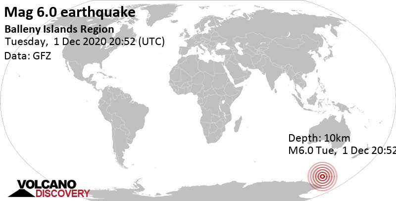
A very strong magnitude 6.0 earthquake occurred in the South Pacific Ocean near the coast of  n/a in the early morning of Wednesday, Dec 2, 2020 at 6.52 am local time (GMT +10). The quake had a very shallow depth of 10 km (6 mi) and was not felt (or at least not reported so).

Very strong mag. 6.0 Earthquake - Balleny Islands Region on Wednesday, Dec 2, 2020, at 06:52 am (GMT +10) Very strong mag. 6.0 Earthquake - Balleny Islands Region on Wednesday, Dec 2, 2020, at 06:52 am (GMT +10)
Very strong magnitude 6.0 earthquake at 10 km depth
1 Dec 21:04 UTC: First to report: GFZ after 11 minutes.
1 Dec 21:12: Magnitude recalculated from 5.6 to 5.7. Epicenter location corrected by 21 km (13 mi) towards WNW.
1 Dec 21:15: Magnitude recalculated from 5.7 to 6.0.

Earthquake details

Date & timeDec 1, 2020 20:52:58 UTC
Local time at epicenterWednesday, Dec 2, 2020, at 06:52 am (GMT +10)
StatusPreliminary (automatic detection)
Magnitude6.0
Depth10 km
Epicenter latitude / longitude62°S / 154.53°EInternational Territory (not near any country)
Seismic antipode62°N / 25.47°W Iceland
Shaking intensityVI Strong shaking near epicenter
Felt0 reports
Primary data sourceGFZ (German Research Centre for Geosciences)
Weather at epicenter at time of quakeLight Rain -0.2°C (32 F), humidity: 98%, wind: 13 m/s (25 kts) from ESE
Estimated seismic energy released6.3 x 1013 joules (17.5 gigawatt hours, equivalent to 15080 tons of TNT or 0.9 atomic bombs!) | about seismic energy
[smaller] [bigger]

Nearby places

User-reports for this quake

There are no user reports for this quake yet.

If you felt it, be the first to report it!
User reports estimate the perceived ground shaking intensity according to the MMI (Modified Mercalli Intensity) scale.
There are no user reports for this quake.

Compare Quake Data

Data for the same earthquake as reported by different agencies

The more agencies report about the same quake and post similar data, the more confidence you can have in the data. It takes normally up to a few hours until earthquake parameters are calculated with near-optimum precision.
Mag Depth Time GMT
2020-12-1
Epicenter Agency
6.0 10 km
6.2 mi
(*)
20:52:58 Balleny Islands Region GFZ (German Research Centre for Geosciences)
6.0 2 km
1.2 mi
20:52:55 BALLENY ISLANDS REGION
16 km (10.1 mi) epicenter difference with GFZ
EMSC (European-Mediterranean Seismological Centre)
6.0 10 km
6.2 mi
(*)
20:52:57 Balleny Islands region
12 km (7.5 mi) epicenter difference with GFZ
USGS (United States Geological Survey)
5.6 10 km
6.2 mi
(*)
20:52:56 Balleny Islands Region
47 km (29 mi) epicenter difference with GFZ
BMKG (Meteorological, Climatological, and Geophysical Agency of Indonesia)
6.2 10 km
6.2 mi
(*)
20:52:56 Balleny Islands Region
19 km (12 mi) epicenter difference with GFZ
GeoAu (Geoscience Australia )
Notes:
(*) A depth given as 10 km often means that the the depth of the quake could not determined with sufficient accuracy.

Seismograms

Seismic station: Dry Valley, Vanda, Antarctica (VNDA/GT network) | Distance from quake: 1745 km / 1084 mi | Show on map | Station Info
Seismic station Dry Valley, Vanda, Antarctica: vertical movement plot around time of quake (source: IRIS/BUD)
Seismogram (vertical component) around time of quake. Thin dotted red line indicates time of quake. Seismic waves arrive some time later, depending on distance. Bandpass filter applied: 0.02-2.0 Hz. Source: IRIS Buffer of Uniform Data (BUD) webtool
Show more

Aftershocks for this quake

So far, only one aftershock has been recorded. It hit 5 days after the mainshock in 11.8 km (7 mi) distance. When more aftershocks are detected, we will update this section.

What are aftershocks?


Larger earthquakes (above magnitude 5 or so) such as this one are usually followed by smaller ones known as aftershocks that occur in the same area during the days, weeks, months or even years after the main shock.
[More info]

What about this quake?


Based on its magnitude, the fault that was active during the quake likely ruptured beneath a surface of approx. 100 km2 (=39 sqare miles) as a first-order estimate. The length of the rupture zone thus was probably around 17 km (11 mi).
[More info]


Recorded aftershocks, latest first (1 quake)

Date and Time GMTMag
Depth
DistanceRegionDetails
Dec 6, 2020 10:11 pm (GMT +10)
3 years ago
5 days after main shock
4.9

10 km
12 km (7.3 mi)
NE of main shock
Balleny Islands RegionMore
Dec 2, 2020 06:52 am (GMT +10)
3 years ago
6.0

10 km
0 km - This quakeBalleny Islands Region
Main Shock (this quake)
More

Map of aftershocks

Previous quakes in the same area of this earthquake

Map of earlier quakes in the area of this quake

[smaller] [bigger]

Map to embed or share

Try our free app!
Volcanoes & Earthquakes - new app for Android
Android | iOS version
Why is there advertising on this site?

Support us - Help us upgrade our services!

We truly love working to bring you the latest volcano and earthquake data from around the world. Maintaining our website and our free apps does require, however, considerable time and resources.
We need financing to increase hard- and software capacity as well as support our editor team. We're aiming to achieve uninterrupted service wherever an earthquake or volcano eruption unfolds, and your donations can make it happen! Every donation will be highly appreciated. If you find the information useful and would like to support our team in integrating further features, write great content, and in upgrading our soft- and hardware, please make a donation (PayPal or Online credit card payment).

Planned features:Thanks to your past donations, these features have been added recently:
Download and Upgrade the Volcanoes & Earthquakes app to get one of the fastest seismic and volcano alerts online:
Android | IOS
Thank you!
Sources: VolcanoDiscovery / VolcanoAdventures and other sources as noted.
Use of material: Most text and images on our websites are owned by us. Re-use is generally not permitted without authorization. Contact us for licensing rights.
Volcanoes & Earthquakes
VolcanoDiscovery Home
Volcanoes | Earthquakes | Photos | Volcano News | App
Adventure & Study Travel
Tours to Volcanoes and Volcanic Areas: walking tours, photo tours, study tours
Tours & Dates | FAQ | About us
Get our newsletter!
Company info
Contact | Legal info | Terms & conditions
Follow us
Follow us on facebook Follow us on Instagram Follow us on Twitter Visit our Youtube channel
EN | DE | EL | ES | FR | IT | RU
VolcanoDiscovery GmbH, Germany, Reg. nr.: HRB 103744, EU Tax Id: DE 297 465 123 owned and created by
Dr. Tom Pfeiffer, volcanologist, volcano photographer, tour organizer member of
IAVCEI
IAVCEI
Vulkanologische Gesellschaft
Volcanological Society
Ecotourism Greece
Ecotourism Greece
RUV insurance
Insured by R+V
VolcanoDiscovery © 2004- All Rights Reserved | Privacy - Cookie Settings