

Translate
En lima / not felt
Padang / Very weak shaking (MMI II) / single lateral shake / 2-5 s


A very strong magnitude 6.1 earthquake occurred in the Indian Ocean 138 km (86 mi) from ![]() Indonesia in the early morning of Tuesday, Apr 20, 2021 at 5.58 am local time (GMT +6). The quake had a very shallow depth of 16 km (10 mi) and was reported felt by some people near the epicenter.
Indonesia in the early morning of Tuesday, Apr 20, 2021 at 5.58 am local time (GMT +6). The quake had a very shallow depth of 16 km (10 mi) and was reported felt by some people near the epicenter.
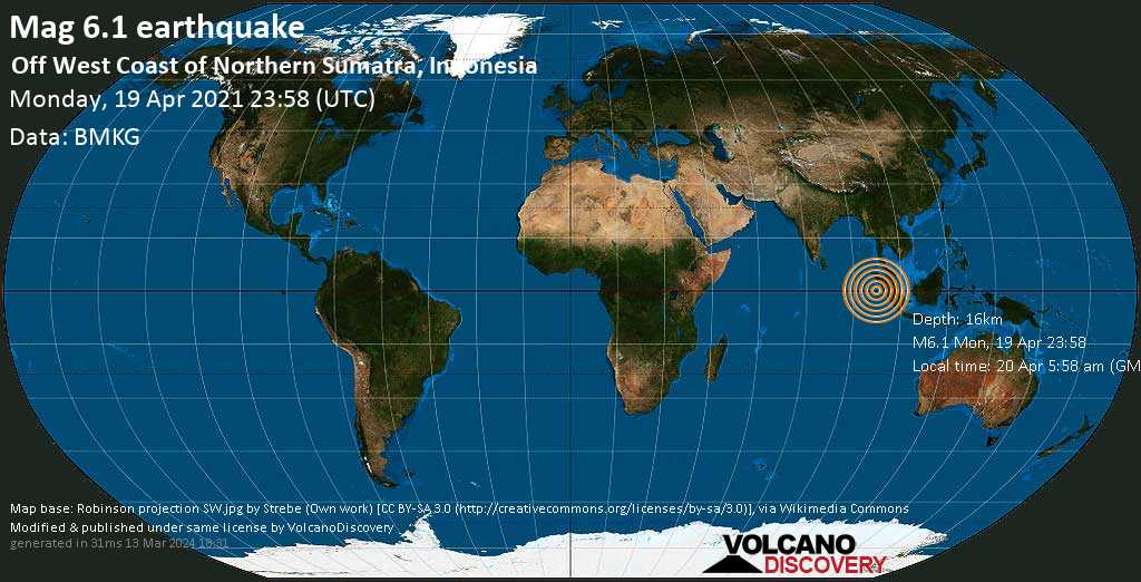
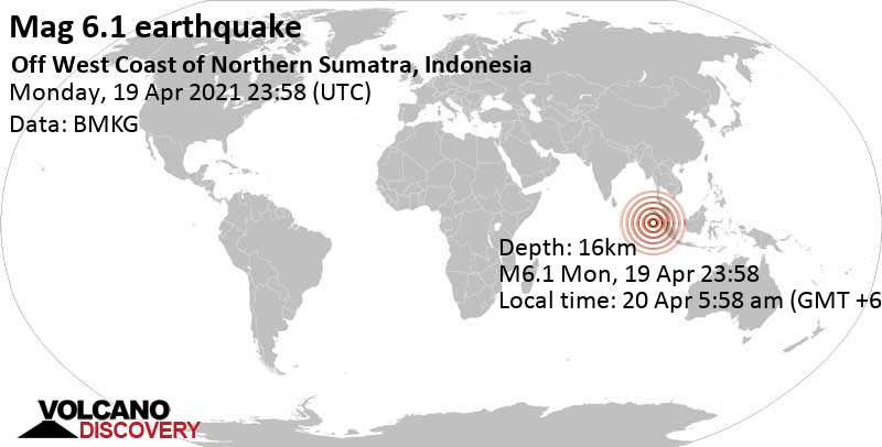
| Date & time | Apr 19, 2021 23:58:22 UTC |
| Local time at epicenter | Tuesday, Apr 20, 2021, at 05:58 am (GMT +6) |
| Status | Preliminary (automatic detection) |
| Magnitude | 6.1 |
| Depth | 16 km |
| Epicenter latitude / longitude | 0.17°N / 96.48°E |
| Seismic antipode | 0.17°S / 83.52°W |
| Shaking intensity | VI Strong shaking near epicenter |
| Felt | 1 report |
| Primary data source | BMKG (Meteorological, Climatological, and Geophysical Agency of Indonesia) |
| Weather at epicenter at time of quake | Scattered Clouds  28°C (82 F), humidity: 72%, wind: 2 m/s (4 kts) from NNE 28°C (82 F), humidity: 72%, wind: 2 m/s (4 kts) from NNE |
| Estimated seismic energy released | 8.9 x 10¹³ joules (24.8 gigawatt hours, equivalent to 21301 tons of TNT or 1.3 atomic bombs!) | about seismic energy |
Distance |
Place | Max. shaking intensity(*) | Region | Country |
|---|---|---|---|---|
| 257 km (160 mi) N of epicenter |
Sinabang (pop: 15,000) |
IV: Light |
Aceh | |
| 277 km (172 mi) NE of epicenter |
Singkil (pop: 46,800) |
IV: Light |
Aceh | |
| 310 km (193 mi) NE of epicenter |
Sibolga (pop: 79,700) |
III: Weak |
North Sumatra | |
| 338 km (210 mi) NE of epicenter |
Padangsidempuan (pop: 100,600) |
III: Weak |
North Sumatra | |
| 423 km (263 mi) NE of epicenter |
Pematangsiantar (pop: 209,600) |
III: Weak |
North Sumatra | |
| 430 km (267 mi) NE of epicenter |
Rantauprapat (pop: 103,000) |
III: Weak |
North Sumatra | |
| 442 km (275 mi) NE of epicenter |
Binjai (pop: 228,800) |
III: Weak |
North Sumatra | |
| 447 km (278 mi) NE of epicenter |
Sunggal (pop: 157,900) |
III: Weak |
North Sumatra | |
| 451 km (280 mi) NE of epicenter |
Medan (pop: 1,751,000) |
III: Weak |
North Sumatra | |
| 467 km (290 mi) NE of epicenter |
Percut (pop: 311,100) |
III: Weak |
North Sumatra |
| Mag | Depth | Time GMT 2021-04-19 |
Epicenter | Agency |
|---|---|---|---|---|
| 6.1 | 16 km 9.9 mi |
23:58:22 | Off West Coast of Northern Sumatra, Indonesia | BMKG (Meteorological, Climatological, and Geophysical Agency of Indonesia) |
| 6.0 | 30 km 19 mi |
23:58:25 | NIAS REGION, INDONESIA 13 km (8.3 mi) epicenter difference with BMKG |
EMSC (European-Mediterranean Seismological Centre) |
| 5.9 | 10 km 6.2 mi (*) |
23:58:23 | Near Medan, Indonesia 28 km (17 mi) epicenter difference with BMKG |
RENASS (Réseau National de Surveillance Sismique (RéNaSS)) |
| 6.0 | 10 km 6.2 mi (*) |
23:58:22 | Off West Coast of Northern Sumatra, Indonesia 5.7 km (3.5 mi) epicenter difference with BMKG |
GFZ (German Research Centre for Geosciences) |
| 6.1 | 9 km 5.6 mi |
23:58:22 | 255 Km S of Sinabang, Indonesia 9.2 km (5.7 mi) epicenter difference with BMKG |
USGS (United States Geological Survey) |
| 6.1 | 18 km 11 mi |
23:58:24 | Off West Coast of Northern Sumatra, Indonesia 16 km (9.7 mi) epicenter difference with BMKG |
GeoAu (Geoscience Australia ) |
| 5.9 | 10 km 6.2 mi (*) |
23:58:22 | 印尼苏门答腊岛西部海域, Indonesia 16 km (10 mi) epicenter difference with BMKG |
CEIC (China Earthquake Networks Center) |
| 6.1 | 20 km 12 mi |
23:58:25 | Off West Coast of Northern Sumatera, Indonesia [Sea: Indonesia] 16 km (10 mi) epicenter difference with BMKG |
INGV (Istituto Nazionale di Geofisica e Vulcanologia) |
Date and Time GMT | Mag Depth | Distance | Region | Details |
|---|---|---|---|---|
| Jul 10, 2021 06:26 am (GMT +6) 3 years ago 12 weeks after main shock | 4.0 10 km | 8.5 km (5.3 mi) NE of main shock | Indonesia: Off West Coast of Northern Sumatra | More |
| Jun 25, 2021 05:19 pm (GMT +6) 3 years ago 9 weeks after main shock | 3.6 10 km | 22 km (14 mi) SE of main shock | Southwest of Sumatra, Indonesia | More |
| Jun 25, 2021 05:10 pm (GMT +6) 3 years ago 9 weeks after main shock | 3.3 10 km | 24 km (15 mi) SE of main shock | Indonesia: Off West Coast of Northern Sumatra | More |
| Jun 17, 2021 07:57 pm (GMT +6) 3 years ago 8 weeks after main shock | 3.4 10 km | 19 km (12 mi) E of main shock | Indonesia: Off West Coast of Northern Sumatra | More |
| Jun 8, 2021 01:03 am (GMT +6) 3 years ago 7 weeks after main shock | 3.6 13 km | 12 km (7.7 mi) SW of main shock | Indonesia: Off West Coast of Northern Sumatra | More |
| Jun 5, 2021 08:14 pm (GMT +6) 3 years ago 7 weeks after main shock | 3.9 10 km | 21 km (13 mi) N of main shock | Indonesia: Off West Coast of Northern Sumatra | More |
| Jun 5, 2021 06:06 pm (GMT +6) 3 years ago 7 weeks after main shock | 4.9 10 km | 9.6 km (5.9 mi) SE of main shock | Indonesia: Off West Coast of Northern Sumatra | More |
| May 31, 2021 06:16 pm (GMT +6) 3 years ago 6 weeks after main shock | 4.2 19 km | 19 km (12 mi) NE of main shock | Indonesia: Off West Coast of Northern Sumatra | More |
| May 31, 2021 05:47 am (GMT +6) 3 years ago 6 weeks after main shock | 4.1 10 km | 24 km (15 mi) SE of main shock | Indonesia: Off West Coast of Northern Sumatra | More |
| May 31, 2021 01:13 am (GMT +6) 3 years ago 6 weeks after main shock | 4.1 22 km | 4.6 km (2.8 mi) E of main shock | Indonesia: Off West Coast of Northern Sumatra | More |
| May 30, 2021 05:48 am (GMT +6) 3 years ago 6 weeks after main shock | 4.0 10 km | 15 km (9.3 mi) NE of main shock | Indonesia: Off West Coast of Northern Sumatra | More |
| May 28, 2021 07:08 am (GMT +6) 3 years ago 5 weeks after main shock | 4.6 17 km | 2.5 km (1.5 mi) NW of main shock | Indonesia: Off West Coast of Northern Sumatra | More |
| May 26, 2021 03:00 pm (GMT +6) 3 years ago 5 weeks after main shock | 3.8 18 km | 21 km (13 mi) E of main shock | Indonesia: Off West Coast of Northern Sumatra | More |
| May 25, 2021 04:16 am (GMT +6) 3 years ago 5 weeks after main shock | 3.8 16 km | 18 km (10.9 mi) SE of main shock | Indonesia: Off West Coast of Northern Sumatra | More |
| May 24, 2021 10:10 pm (GMT +6) 3 years ago 5 weeks after main shock | 3.6 10 km | 20 km (13 mi) E of main shock | Indonesia: Off West Coast of Northern Sumatra | More |
| May 24, 2021 08:17 am (GMT +6) 3 years ago 5 weeks after main shock | 3.8 12 km | 21 km (13 mi) E of main shock | Indonesia: Off West Coast of Northern Sumatra | More |
| May 23, 2021 08:01 pm (GMT +6) 3 years ago 5 weeks after main shock | 2.9 25 km | 15 km (9 mi) N of main shock | Indonesia: Off West Coast of Northern Sumatra | More |
| May 21, 2021 05:16 am (GMT +6) 3 years ago 4 weeks after main shock | 3.6 10 km | 20 km (13 mi) S of main shock | Southwest of Sumatra, Indonesia | More |
| May 20, 2021 09:23 pm (GMT +6) 3 years ago 4 weeks after main shock | 3.5 10 km | 19 km (12 mi) S of main shock | Southwest of Sumatra, Indonesia | More |
| May 20, 2021 06:05 am (GMT +6) 3 years ago 4 weeks after main shock | 4.0 10 km | 17 km (10.4 mi) E of main shock | Indonesia: Off West Coast of Northern Sumatra | More |
| May 20, 2021 05:47 am (GMT +6) 3 years ago 4 weeks after main shock | 4.3 28 km | 23 km (14 mi) NE of main shock | Indonesia: Off West Coast of Northern Sumatra | More |
| May 19, 2021 03:17 pm (GMT +6) 3 years ago 4 weeks after main shock | 4.5 10 km | 12 km (7.3 mi) SW of main shock | Indonesia: Off West Coast of Northern Sumatra | More |
| May 17, 2021 06:21 pm (GMT +6) 3 years ago 4 weeks after main shock | 5.3 13 km | 5.6 km (3.5 mi) SE of main shock | Indonesia: Off West Coast of Northern Sumatra | More |
| May 15, 2021 11:47 pm (GMT +6) 3 years ago 4 weeks after main shock | 4.0 10 km | 10.6 km (6.6 mi) S of main shock | Off West Coast of Northern Sumatra, Indonesia | More |
| May 15, 2021 11:04 pm (GMT +6) 3 years ago 4 weeks after main shock | 3.9 20 km | 10.5 km (6.5 mi) SE of main shock | Off West Coast of Northern Sumatra, Indonesia | More |
| May 15, 2021 02:42 am (GMT +6) 3 years ago 4 weeks after main shock | 3.9 10 km | 7.1 km (4.4 mi) SW of main shock | Off West Coast of Northern Sumatra, Indonesia | More |
| May 15, 2021 02:29 am (GMT +6) 3 years ago 4 weeks after main shock | 3.4 12 km | 15 km (9.1 mi) S of main shock | Off West Coast of Northern Sumatra, Indonesia | More |
| May 15, 2021 02:25 am (GMT +6) 3 years ago 4 weeks after main shock | 3.1 14 km | 20 km (13 mi) NE of main shock | Off West Coast of Northern Sumatra, Indonesia | More |
| May 15, 2021 12:51 am (GMT +6) 3 years ago 4 weeks after main shock | 4.7 10 km | 17 km (10.8 mi) SE of main shock | Off West Coast of Northern Sumatra, Indonesia | More |
| May 14, 2021 03:48 pm (GMT +6) 3 years ago 3 weeks after main shock | 4.5 48 km | 13 km (8.1 mi) SE of main shock | Off West Coast of Northern Sumatra, Indonesia | More |
| May 14, 2021 03:16 pm (GMT +6) 3 years ago 3 weeks after main shock | 5.2 10 km | 19 km (12 mi) S of main shock | Off West Coast of Northern Sumatra, Indonesia | More |
| May 14, 2021 02:10 pm (GMT +6) 3 years ago 3 weeks after main shock | 4.0 10 km | 18 km (10.9 mi) E of main shock | Northern Sumatra, Indonesia | More |
| May 14, 2021 01:53 pm (GMT +6) 3 years ago 3 weeks after main shock | 3.9 10 km | 11 km (7.1 mi) SE of main shock | Off West Coast of Northern Sumatra, Indonesia | More |
| May 14, 2021 01:32 pm (GMT +6) 3 years ago 3 weeks after main shock | 3.9 21 km | 10.5 km (6.5 mi) SE of main shock | Off West Coast of Northern Sumatra, Indonesia | More |
| May 14, 2021 01:27 pm (GMT +6) 3 years ago 3 weeks after main shock | 4.0 24 km | 15 km (9.2 mi) S of main shock | Off West Coast of Northern Sumatra, Indonesia | More |
| May 14, 2021 01:16 pm (GMT +6) 3 years ago 3 weeks after main shock | 5.0 10 km | 15 km (9.6 mi) E of main shock | Off West Coast of Northern Sumatra, Indonesia | More |
| May 14, 2021 12:33 pm (GMT +6) 3 years ago - felt 3 weeks after main shock | 6.7 10 km | 20 km (12 mi) E of main shock | Off West Coast of Northern Sumatra, Indonesia | More |
| May 3, 2021 08:11 pm (GMT +6) 3 years ago 14 days after main shock | 4.6 24 km | 18 km (10.9 mi) NE of main shock | Off West Coast of Northern Sumatra, Indonesia | More |
| Apr 28, 2021 09:23 am (GMT +6) 3 years ago 8 days after main shock | 3.9 10 km | 11 km (6.9 mi) E of main shock | Off West Coast of Northern Sumatra, Indonesia | More |
| Apr 27, 2021 09:31 pm (GMT +6) 3 years ago 8 days after main shock | 3.6 61 km | 24 km (15 mi) NE of main shock | Off West Coast of Northern Sumatra, Indonesia | More |
| Apr 25, 2021 06:19 am (GMT +6) 3 years ago 5 days after main shock | 4.1 68 km | 19 km (12 mi) SW of main shock | Off West Coast of Northern Sumatra, Indonesia | More |
| Apr 25, 2021 05:35 am (GMT +6) 3 years ago 5 days after main shock | 4.4 10 km | 8.7 km (5.4 mi) SW of main shock | Off West Coast of Northern Sumatra, Indonesia | More |
| Apr 24, 2021 05:04 pm (GMT +6) 3 years ago 4 days after main shock | 4.3 10 km | 18 km (11 mi) E of main shock | Off West Coast of Northern Sumatra, Indonesia | More |
| Apr 21, 2021 07:34 pm (GMT +6) 3 years ago 1 day 14 hours after main shock | 3.3 26 km | 21 km (13 mi) E of main shock | Off West Coast of Northern Sumatra, Indonesia | More |
| Apr 21, 2021 08:00 am (GMT +6) 3 years ago 1 day 2 hours after main shock | 3.5 10 km | 11 km (6.8 mi) NE of main shock | Off West Coast of Northern Sumatra, Indonesia | More |
| Apr 21, 2021 01:36 am (GMT +6) 3 years ago 20 hours after main shock | 3.3 15 km | 11 km (7.1 mi) SW of main shock | Off West Coast of Northern Sumatra, Indonesia | More |
| Apr 20, 2021 08:23 am (GMT +6) 3 years ago 2 hours and 25 minutes after main shock | 4.0 10 km | 7 km (4.4 mi) S of main shock | Off West Coast of Northern Sumatra, Indonesia | More |
| Apr 20, 2021 08:07 am (GMT +6) 3 years ago 2 hours and 9 minutes after main shock | 3.6 10 km | 16 km (9.8 mi) NE of main shock | Off West Coast of Northern Sumatra, Indonesia | More |
| Apr 20, 2021 05:58 am (GMT +6) 3 years ago | 6.1 16 km | 0 km - This quake | Indian Ocean, 165 km SW of Nias Island, North Sumatra, Indonesia Main Shock (this quake) | More |
Date and Time | Mag Depth | Distance | Location | Details | Map |
|---|---|---|---|---|---|
| Apr 14, 2021 04:55 pm (GMT +6) | 5.5 10 km | 19 km (12 mi) to the E | Info | ||
| Jan 17, 2021 08:59 pm (GMT +7) | 4.4 19 km | 65 km (40 mi) to the NE | Info | ||
| Sep 21, 2020 05:00 am (GMT +6) | 4.9 10 km | 99 km (62 mi) to the NW | Info | ||
| Sep 13, 2020 02:47 am (GMT +6) | 4.0 10 km | 62 km (39 mi) to the SE | Info | ||
| Sep 4, 2020 09:05 pm (GMT +7) | 4.4 44 km | 52 km (32 mi) to the NE | Info | ||
| Dec 16, 2019 02:59 am (GMT +6) | 4.8 31 km | 27 km (17 mi) to the N | Info | ||
| Dec 5, 2018 05:37 am (GMT +7) | 4.8 10 km | 63 km (39 mi) to the E | Info | ||
| Nov 30, 2018 09:44 am (GMT +7) | 4.8 10 km | 73 km (45 mi) to the E | Info | ||
| Nov 30, 2018 03:21 am (GMT +7) | 5.7 10 km | 66 km (41 mi) to the E | Info | ||
| Sep 6, 2018 07:13 am (GMT +7) | 5.3 10 km | 75 km (47 mi) to the NE | Info | ||
| Mar 3, 2018 03:03 am (GMT +6) | 5.0 10 km | 49 km (31 mi) to the SE | Info | ||
| Jan 26, 2017 07:50 pm (GMT +6) | 4.8 10 km | 72 km (45 mi) to the S | Info | ||
| Nov 8, 2015 07:38 am (GMT +6) | 4.8 10 km | 69 km (43 mi) to the SE | Info | ||
| Jul 27, 2015 06:55 am (GMT +7) | 4.9 30 km | 62 km (38 mi) to the E | Info | ||
| Mar 5, 2015 07:07 am (GMT +7) | 5.2 10 km | 53 km (33 mi) to the E | Info | ||
| Dec 7, 2013 12:49 am (GMT +6) | 4.9 30 km | 86 km (53 mi) to the S | Info | ||
| Sep 16, 2012 11:17 pm (GMT +7) | 4.8 16 km | 59 km (36 mi) to the NE | Info | ||
| Jun 7, 2012 01:27 am (GMT +7) | 4.8 39 km | 60 km (37 mi) to the E | Info | ||
| Dec 22, 2011 07:21 pm (Universal Time) | 5.0 26 km | 84 km (52 mi) to the E | Info | ||
| Jul 21, 2011 01:48 pm (GMT +7) | 4.8 26 km | 58 km (36 mi) to the E | Info | ||
| Apr 7, 2010 05:15 am (Pontianak) | 7.8 31 km | 254 km (158 mi) to the N | Info | ||
| Aug 23, 2009 02:20 pm (GMT +7) | 5.4 35 km | 56 km (35 mi) to the E | Info | ||
| Feb 20, 2008 08:08 am (Universal Time) | 7.4 26 km | 295 km (183 mi) to the N | Info | ||
| Feb 14, 2007 08:46 pm (Universal Time) | 5.4 4.7 km | 99 km (61 mi) to the NE | Info | ||
| Feb 14, 2007 07:49 pm (Universal Time) | 5.7 16 km | 97 km (60 mi) to the E | Info | ||
| Sep 3, 2006 11:20 pm (GMT +7) | 5.4 49 km | 78 km (48 mi) to the E | Info | ||
| May 16, 2006 10:28 pm (GMT +7) | 6.8 12 km | 64 km (40 mi) to the E | Info | ||
| Apr 25, 2005 08:18 pm (Universal Time) | 5.6 36 km | 91 km (57 mi) to the E | Info | ||
| Mar 29, 2005 11:50 am (GMT +7) | 5.5 36 km | 68 km (43 mi) to the E | Info | ||
| Mar 29, 2005 06:13 am (GMT +7) | 5.7 39 km | 63 km (39 mi) to the E | Info | ||
| Mar 28, 2005 11:09 pm (Pontianak) | 8.6 30 km | 224 km (139 mi) to the N | Info | ||
| Dec 26, 2004 08:53 am (GMT +6) | 5.4 30 km | 64 km (40 mi) to the E | Info | ||
| Nov 2, 2002 01:26 am (Universal Time) | 7.4 30 km | 298 km (185 mi) to the N | Info | ||
| Nov 17, 1984 01:49 pm (Jakarta) | 7.1 33 km | 172 km (107 mi) to the E | Info | ||
| Dec 30, 1980 10:48 pm (GMT +7) | 5.4 33 km | 92 km (57 mi) to the E | Info | ||
| Feb 4, 1971 10:33 pm (Jakarta) | 7.0 30 km | 254 km (158 mi) to the E | Info | ||
| Mar 31, 1963 11:28 pm (GMT +6) | 5.6 19 km | 51 km (32 mi) to the N | Info | ||
| Mar 26, 1963 05:46 am (GMT +7) | 5.7 18 km | 65 km (40 mi) to the N | Info | ||
| Dec 28, 1935 02:35 am (Universal Time) | 7.6 30 km | 202 km (126 mi) to the E | Info | ||
| Feb 12, 1918 09:00 am (GMT +6) | 6.2 15 km | 42 km (26 mi) to the E | Info | ||
| Oct 29, 1913 11:32 am (GMT +7) | 6.2 25 km | 81 km (51 mi) to the E | Info |


