Contact | RSS | EN | DE | EL | ES | FR | IT | RU

Very strong mag. 6.0 earthquake - North Pacific Ocean, 195 km south of David, Provincia de Chiriqui, Panama, on Thursday, 13 May 2021 at 09:42 (GMT)

Very strong mag. 6.0 Earthquake - South of Panama on Thursday, May 13, 2021, at 04:42 am (GMT -5)

A very strong magnitude 6.0 earthquake occurred in the North Pacific Ocean 95 km (59 mi) from  Panama in the early morning of Thursday, May 13, 2021 at 4.42 am local time (GMT -5). The quake had a very shallow depth of 10 km (6 mi) and was reported felt by some people near the epicenter.
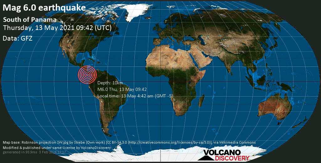
Very strong mag. 6.0 Earthquake - South of Panama on Thursday, May 13, 2021, at 04:42 am (GMT -5) Very strong mag. 6.0 Earthquake - South of Panama on Thursday, May 13, 2021, at 04:42 am (GMT -5)
Very strong magnitude 6.0 earthquake at 10 km depth
13 May 09:49 UTC: First to report: GFZ after 7 minutes.
13 May 09:50: Epicenter location corrected by 1.6 km (1 mi) towards NE.
13 May 10:06: Magnitude recalculated from 5.8 to 5.9.
13 May 10:35: Magnitude recalculated from 5.9 to 6.0. Epicenter location corrected by 5 km (3.1 mi) towards SSW.

Earthquake details

Date & timeMay 13, 2021 09:42:13 UTC
Local time at epicenterThursday, May 13, 2021, at 04:42 am (GMT -5)
StatusConfirmed
Magnitude6.0
Depth10 km
Epicenter latitude / longitude6.67°N / 82.45°W North Pacific Ocean, Panama
Also near: Costa Rica 159 km (99 mi) away
Seismic antipode6.67°S / 97.55°E
Shaking intensityVI Strong shaking near epicenter
Felt1 report
Primary data sourceGFZ (German Research Centre for Geosciences)
Nearest volcanoBaru (234 km / 145 mi)
Weather at epicenter at time of quakeBroken Clouds 27.5°C (82 F), humidity: 75%, wind: 2 m/s (3 kts) from SW
Estimated seismic energy released6.3 x 1013 joules (17.5 gigawatt hours, equivalent to 15080 tons of TNT or 0.9 atomic bombs!) | about seismic energy
[smaller] [bigger]

Nearby places

The closest larger town where the quake might have been felt is Bahia Honda, a town with 216 inhabitants in Panama, in 158 km (98 mi) distance northeast of the epicenter. People likely experienced light shaking there. In the capital of  Panama, Panama, 414 km (257 mi) away from the epicenter, the earthquake was probably felt as weak shaking.
The following table shows some of the places that might have been affected (or not) by the shaking.
Distance Place Max. shaking intensity(*) Region Country
158 km (98 mi)
NE of epicenter
Bahia Honda
(pop: 216)
IV: Light
Sona, Veraguas
185 km (115 mi)
N of epicenter
Puerto Armuelles
(pop: 11,700)
IV: Light
Baru, Chiriqui
190 km (118 mi)
N of epicenter
Pedregal
(pop: 17,400)
IV: Light
David, Chiriqui
194 km (121 mi)
NE of epicenter
Sona
(pop: 7,670)
IV: Light
Sona, Veraguas
195 km (121 mi)
NE of epicenter
Tolé
(pop: 2,790)
IV: Light
Chiriqui
195 km (121 mi)
N of epicenter
David
(pop: 82,000)
IV: Light
Chiriqui
196 km (122 mi)
N of epicenter
Las Lomas
(pop: 11,700)
IV: Light
David, Chiriqui
196 km (122 mi)
N of epicenter
Divala
(pop: 2,510)
IV: Light
Alanje, Chiriqui
227 km (141 mi)
NE of epicenter
Santiago
(pop: 45,400)
IV: Light
Veraguas
414 km (257 mi)
NE of epicenter
Panama
(pop: 408,200)
III: Weak
Panama, Panama
Notes:
(*) Shaking intensity according to the Modified Mercalli Intensity Scale (MMI) and estimated using seismic models.

User-reports for this quake (2)

We received 2 reports for this quake.
User reports estimate the perceived ground shaking intensity according to the MMI (Modified Mercalli Intensity) scale.
Translate
Renacimiento / not felt
Santa Fe, Veraguas / Very weak shaking (MMI II) / single lateral shake / very short

What is Intensity and the Mercalli Intensity Scale?


The amount of shaking that occurs on the surface due to an earthquake is called the intensity. It is commonly measured on the so-called Modified Mercalli Intensity Scale (MMI) ranging from 1 (not felt) to 10 (extreme shaking), and given in Roman numerals as I,II,...IX, X, and often displayed with color codes ranging from light blue to dark red.
Earthquake intensity depends mainly on the magnitude and depth of the quake as well as the distance from the epicenter: The further away, the less shaking intensity occurs.
Read more about the MMI scale!

Compare Quake Data

Data for the same earthquake as reported by different agencies

The more agencies report about the same quake and post similar data, the more confidence you can have in the data. It takes normally up to a few hours until earthquake parameters are calculated with near-optimum precision.
Mag Depth Time GMT
2021-05-13
Epicenter Agency
6.0 10 km
6.2 mi
(*)
09:42:13 South of Panama GFZ (German Research Centre for Geosciences)
6.0 10 km
6.2 mi
(*)
09:42:11 SOUTH OF PANAMA
15 km (9.6 mi) epicenter difference with GFZ
EMSC (European-Mediterranean Seismological Centre)
5.1 10 km
6.2 mi
(*)
09:42:12 Near David, Panama
7.4 km (4.6 mi) epicenter difference with GFZ
RENASS (Réseau National de Surveillance Sismique (RéNaSS))
5.7 10 km
6.2 mi
(*)
09:42:11 88 Km Al Suroeste De Isla Jicarón, Distrito Montijo, Panamá, Panama
9.7 km (6 mi) epicenter difference with GFZ
INETER
6.0 10.2 km
6.3 mi
09:42:12 South of Panama [Sea: Panama]
11 km (7.1 mi) epicenter difference with GFZ
INGV (Istituto Nazionale di Geofisica e Vulcanologia)
6.1 10 km
6.2 mi
(*)
09:42:12 154 km SSE of Punta de Burica, Panama
6.2 km (3.9 mi) epicenter difference with GFZ
USGS (United States Geological Survey)
6.0 11 km
7 mi
09:42:12 South of Panama
14 km (8.4 mi) epicenter difference with GFZ
GeoAu (Geoscience Australia )
5.5 37 km
23 mi
09:42:15 South of Panama
17 km (10.4 mi) epicenter difference with GFZ
BMKG (Meteorological, Climatological, and Geophysical Agency of Indonesia)
5.7 10 km
6.2 mi
(*)
09:42:00 113 Km Al Suroeste De Isla De Coiba, Panama.
8 km (5 mi) epicenter difference with GFZ
RSN
Notes:
(*) A depth given as 10 km often means that the the depth of the quake could not determined with sufficient accuracy.

Seismograms

Seismic station: Las Juntas de Abangares, Costa Rica (JTS/II network) | Distance from quake: 488 km / 303 mi | Show on map | Station Info
Seismic station Las Juntas de Abangares, Costa Rica: vertical movement plot around time of quake (source: IRIS/BUD)
Seismogram (vertical component) around time of quake. Thin dotted red line indicates time of quake. Seismic waves arrive some time later, depending on distance. Bandpass filter applied: 0.1-10.0 Hz. Source: IRIS Buffer of Uniform Data (BUD) webtool
Show more

Aftershocks for this quake

So far, only one aftershock has been recorded. It hit 4 weeks after the mainshock in 19.5 km (12 mi) distance. When more aftershocks are detected, we will update this section.

What are aftershocks?


Larger earthquakes (above magnitude 5 or so) such as this one are usually followed by smaller ones known as aftershocks that occur in the same area during the days, weeks, months or even years after the main shock.
[More info]

What about this quake?


Based on its magnitude, the fault that was active during the quake likely ruptured beneath a surface of approx. 100 km2 (=39 sqare miles) as a first-order estimate. The length of the rupture zone thus was probably around 17 km (11 mi).
[More info]


Recorded aftershocks, latest first (1 quake)

Date and Time GMTMag
Depth
DistanceRegionDetails
Jun 9, 2021 11:17 pm (GMT -5)
3 years ago
4 weeks after main shock
3.9

15 km
19 km (12 mi)
SW of main shock
137 Km Al Suroeste De Isla De Coiba, Panama.More
May 13, 2021 04:42 am (GMT -5)
3 years ago - felt
6.0

10 km
0 km - This quakeNorth Pacific Ocean, 195 km S of David, Chiriqui, Panama
Main Shock (this quake)
More

Map of aftershocks

Earthquake statistics

Average number of earthquakes

Based on data from the past 54 years and our earthquake archive back to 1900, there are about 60 quakes on average per year in the area near the epicenter of this quake (within 100 km/61 mi):
  • Mag. 6 or higher: 0.33 quakes per year (or 1 quake every 3 years)
  • Mag. 5 or higher: 1.53 quakes per year
  • Mag. 4 or higher: 24.3 quakes per year
  • Mag. 3 or higher: 59 quakes per year (or 4.9 quakes per month)
  • Mag. 2 or higher: 59 quakes per year (or 5 quakes per month)
The area where this quake occurred has a very high level of seismic activity. It has had at least 41 quakes above magnitude 6 since 1900, which suggests that larger earthquakes of this size occur infrequently, probably on average approximately every 1 to 5 years.

Number of quakes per year

Previous quakes in the same area of this earthquake

Map of earlier quakes in the area of this quake

[smaller] [bigger]

Map to embed or share

Try our free app!
Volcanoes & Earthquakes - new app for Android
Android | iOS version
Why is there advertising on this site?

Support us - Help us upgrade our services!

We truly love working to bring you the latest volcano and earthquake data from around the world. Maintaining our website and our free apps does require, however, considerable time and resources.
We need financing to increase hard- and software capacity as well as support our editor team. We're aiming to achieve uninterrupted service wherever an earthquake or volcano eruption unfolds, and your donations can make it happen! Every donation will be highly appreciated. If you find the information useful and would like to support our team in integrating further features, write great content, and in upgrading our soft- and hardware, please make a donation (PayPal or Online credit card payment).

Planned features:Thanks to your past donations, these features have been added recently:
Download and Upgrade the Volcanoes & Earthquakes app to get one of the fastest seismic and volcano alerts online:
Android | IOS
Thank you!
Sources: VolcanoDiscovery / VolcanoAdventures and other sources as noted.
Use of material: Most text and images on our websites are owned by us. Re-use is generally not permitted without authorization. Contact us for licensing rights.
Volcanoes & Earthquakes
VolcanoDiscovery Home
Volcanoes | Earthquakes | Photos | Volcano News | App
Adventure & Study Travel
Tours to Volcanoes and Volcanic Areas: walking tours, photo tours, study tours
Tours & Dates | FAQ | About us
Get our newsletter!
Company info
Contact | Legal info | Terms & conditions
Follow us
Follow us on facebook Follow us on Instagram Follow us on Twitter Visit our Youtube channel
EN | DE | EL | ES | FR | IT | RU
VolcanoDiscovery GmbH, Germany, Reg. nr.: HRB 103744, EU Tax Id: DE 297 465 123 owned and created by
Dr. Tom Pfeiffer, volcanologist, volcano photographer, tour organizer member of
IAVCEI
IAVCEI
Vulkanologische Gesellschaft
Volcanological Society
Ecotourism Greece
Ecotourism Greece
RUV insurance
Insured by R+V
VolcanoDiscovery © 2004- All Rights Reserved | Privacy - Cookie Settings