

Translate
Singapore / not felt


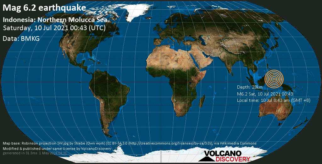
A very strong magnitude 6.2 earthquake occurred in the Maluku Sea 83 km (52 mi) from ![]() Indonesia in the morning of Saturday, Jul 10, 2021 at 8.43 am local time (Asia/Makassar GMT +8). The quake had a very shallow depth of 23 km (14 mi) and was not felt (or at least not reported so).
Indonesia in the morning of Saturday, Jul 10, 2021 at 8.43 am local time (Asia/Makassar GMT +8). The quake had a very shallow depth of 23 km (14 mi) and was not felt (or at least not reported so).
| Date & time | Jul 10, 2021 00:43:57 UTC |
| Local time at epicenter | Saturday, Jul 10, 2021, at 08:43 am (Asia/Makassar GMT +8) |
| Status | Preliminary (automatic detection) |
| Magnitude | 6.2 |
| Depth | 23 km |
| Epicenter latitude / longitude | 2.99°N / 126.64°E |
| Seismic antipode | 2.99°S / 53.36°W |
| Shaking intensity | VI Strong shaking near epicenter |
| Felt | 0 reports |
| Primary data source | BMKG (Meteorological, Climatological, and Geophysical Agency of Indonesia) |
| Nearest volcano | Banua Wuhu (118 km / 73 mi) |
| Weather at epicenter at time of quake | Overcast Clouds  28.6°C (84 F), humidity: 75%, wind: 5 m/s (9 kts) from SSW 28.6°C (84 F), humidity: 75%, wind: 5 m/s (9 kts) from SSW |
| Estimated seismic energy released | 1.3 x 10¹⁴ joules (35 gigawatt hours, equivalent to 30089 tons of TNT or 1.9 atomic bombs!) | about seismic energy |
Distance |
Place | Max. shaking intensity(*) | Region | Country |
|---|---|---|---|---|
| 207 km (129 mi) SE of epicenter |
Tobelo (pop: 10,000) |
IV: Light |
North Maluku | |
| 235 km (146 mi) SW of epicenter |
Bitung (pop: 137,400) |
IV: Light |
North Sulawesi | |
| 258 km (160 mi) S of epicenter |
Ternate (pop: 101,700) |
IV: Light |
North Maluku | |
| 260 km (162 mi) SW of epicenter |
Manado (pop: 451,900) |
IV: Light |
North Sulawesi | |
| 268 km (167 mi) SW of epicenter |
Tondano (pop: 33,300) |
IV: Light |
North Sulawesi | |
| 271 km (168 mi) SE of epicenter |
Sofifi (pop: 36,200) |
IV: Light |
North Maluku | |
| 276 km (172 mi) SW of epicenter |
Tomohon (pop: 27,600) |
IV: Light |
North Sulawesi | |
| 384 km (238 mi) NW of epicenter |
General Santos City (pop: 679,600) |
III: Weak |
South Cotabato, Soccsksargen | |
| 438 km (272 mi) NW of epicenter |
Koronadal (pop: 125,500) |
III: Weak |
South Cotabato, Soccsksargen | |
| 482 km (300 mi) SW of epicenter |
Gorontalo (pop: 144,200) |
III: Weak |
Gorontalo |
| Mag | Depth | Time GMT 2021-07-10 |
Epicenter | Agency |
|---|---|---|---|---|
| 6.2 | 23 km 14 mi |
00:43:57 | Indonesia: Northern Molucca Sea | BMKG (Meteorological, Climatological, and Geophysical Agency of Indonesia) |
| 6.1 | 80 km 50 mi |
00:43:59 | Indonesia: MOLUCCA SEA 15 km (9.4 mi) epicenter difference with BMKG |
EMSC (European-Mediterranean Seismological Centre) |
| 6.1 | 44 km 28 mi |
00:43:56 | Indonesia: Molucca Sea 16 km (10.2 mi) epicenter difference with BMKG |
USGS (United States Geological Survey) |
| 6.2 | 26 km 16 mi |
00:43:53 | Talaud Islands, Indonesia 15 km (9.4 mi) epicenter difference with BMKG |
GFZ (German Research Centre for Geosciences) |
| 5.7 | 10 km 6.2 mi (*) |
00:43:52 | Indonesia: Near Davao 42 km (26 mi) epicenter difference with BMKG |
RENASS (Réseau National de Surveillance Sismique (RéNaSS)) |
| 6.2 | 73 km 45 mi |
00:43:58 | Indonesia [Sea] 10.7 km (6.6 mi) epicenter difference with BMKG |
INGV (Istituto Nazionale di Geofisica e Vulcanologia) |
| 6.1 | 64 km 39 mi |
00:43:57 | Indonesia: Northern Molucca Sea 13 km (8.4 mi) epicenter difference with BMKG |
GeoAu (Geoscience Australia ) |
| 6.2 | 64 km 40 mi |
00:43:00 | Indonesia: 347 Km S 23° E of Sarangani (Davao Occidental) 52 km (32 mi) epicenter difference with BMKG |
PHIVOLCS (Philippine Institute of Volcanology and Seismology) |
Date and Time GMT | Mag Depth | Distance | Region | Details |
|---|---|---|---|---|
| Sep 18, 2021 10:49 pm (Makassar) 3 years ago 10 weeks after main shock | 4.4 10 km | 5.6 km (3.5 mi) E of main shock | Indonesia: Northern Molucca Sea | More |
| Sep 14, 2021 09:32 pm (GMT +8) 3 years ago 10 weeks after main shock | 3.0 10 km | 14 km (8.4 mi) SE of main shock | Indonesia: Northern Molucca Sea | More |
| Aug 14, 2021 05:19 am (GMT +8) 3 years ago 5 weeks after main shock | 3.5 1 km | 13 km (8.3 mi) SE of main shock | Indonesia: 310 Km S 28° E of Sarangani (Davao Occidental) | More |
| Aug 6, 2021 08:07 am (Makassar) 3 years ago 4 weeks after main shock | 3.9 10 km | 7.5 km (4.6 mi) SE of main shock | Indonesia: Northern Molucca Sea | More |
| Jul 28, 2021 08:30 pm (GMT +8) 3 years ago 3 weeks after main shock | 3.3 31 km | 5.7 km (3.5 mi) S of main shock | Indonesia: Northern Molucca Sea | More |
| Jul 24, 2021 10:44 pm (GMT +8) 3 years ago 2 weeks after main shock | 3.4 113 km | 20 km (13 mi) SW of main shock | Indonesia: Northern Molucca Sea | More |
| Jul 24, 2021 09:07 pm (Makassar) 3 years ago 2 weeks after main shock | 5.4 58 km | 4.6 km (2.8 mi) E of main shock | Indonesia: Northern Molucca Sea | More |
| Jul 15, 2021 09:00 pm (Makassar) 3 years ago 6 days after main shock | 4.7 10 km | 27 km (17 mi) E of main shock | Indonesia: Northern Molucca Sea | More |
| Jul 15, 2021 09:00 pm (Makassar) 3 years ago 6 days after main shock | 3.8 51 km | 18 km (11 mi) E of main shock | Indonesia: 313 Km S 29° E of Sarangani (Davao Occidental) | More |
| Jul 14, 2021 12:52 am (GMT +8) 3 years ago 4 days after main shock | 3.1 10 km | 9.4 km (5.9 mi) SE of main shock | Indonesia: Northern Molucca Sea | More |
| Jul 12, 2021 03:16 am (GMT +8) 3 years ago 1 day 19 hours after main shock | 3.6 32 km | 4.7 km (2.9 mi) NW of main shock | Talaud Islands, Indonesia | More |
| Jul 12, 2021 12:07 am (Makassar) 3 years ago 1 day 15 hours after main shock | 4.3 10 km | 9 km (5.6 mi) NE of main shock | Talaud Islands, Indonesia | More |
| Jul 11, 2021 10:36 am (GMT +8) 3 years ago 1 day 2 hours after main shock | 3.2 10 km | 9.2 km (5.7 mi) S of main shock | Indonesia: Northern Molucca Sea | More |
| Jul 11, 2021 10:13 am (GMT +8) 3 years ago 1 day 1 hours after main shock | 3.6 10 km | 10.5 km (6.5 mi) E of main shock | Indonesia: Northern Molucca Sea | More |
| Jul 10, 2021 06:06 pm (Makassar) 3 years ago 9 hours after main shock | 4.8 60 km | 12 km (7.7 mi) SW of main shock | Indonesia: MOLUCCA SEA | More |
| Jul 10, 2021 06:04 pm (Makassar) 3 years ago 9 hours after main shock | 5.0 10 km | 13 km (8.3 mi) E of main shock | Talaud Islands, Indonesia | More |
| Jul 10, 2021 06:04 pm (GMT +8) 3 years ago 9 hours after main shock | 3.5 1 km | 23 km (14 mi) NW of main shock | Indonesia: 280 Km S 25° E of Sarangani (Davao Occidental) | More |
| Jul 10, 2021 05:52 pm (GMT +8) 3 years ago 9 hours after main shock | 3.5 10 km | 7.9 km (4.9 mi) E of main shock | Indonesia: Northern Molucca Sea | More |
| Jul 10, 2021 05:03 pm (GMT +8) 3 years ago 8 hours after main shock | 3.6 28 km | 6.8 km (4.2 mi) E of main shock | Talaud Islands, Indonesia | More |
| Jul 10, 2021 03:58 pm (GMT +8) 3 years ago 7 hours after main shock | 3.5 10 km | 7.1 km (4.4 mi) SE of main shock | Indonesia: Northern Molucca Sea | More |
| Jul 10, 2021 03:25 pm (Makassar) 3 years ago 7 hours after main shock | 3.8 10 km | 1.6 km (1 mi) NE of main shock | Indonesia: Northern Molucca Sea | More |
| Jul 10, 2021 03:09 pm (GMT +8) 3 years ago 6 hours after main shock | 2.8 10 km | 4.6 km (2.8 mi) S of main shock | Indonesia: Northern Molucca Sea | More |
| Jul 10, 2021 02:26 pm (GMT +8) 3 years ago 6 hours after main shock | 3.3 12 km | 5 km (3.1 mi) SE of main shock | Indonesia: Northern Molucca Sea | More |
| Jul 10, 2021 02:23 pm (GMT +8) 3 years ago 6 hours after main shock | 3.4 32 km | 7 km (4.4 mi) E of main shock | Talaud Islands, Indonesia | More |
| Jul 10, 2021 01:47 pm (GMT +8) 3 years ago 5 hours after main shock | 3.5 53 km | 6 km (3.7 mi) E of main shock | Indonesia: Northern Molucca Sea | More |
| Jul 10, 2021 01:35 pm (GMT +8) 3 years ago 5 hours after main shock | 3.4 51 km | 6.5 km (4 mi) NE of main shock | Talaud Islands, Indonesia | More |
| Jul 10, 2021 11:30 am (Makassar) 3 years ago 2 hours and 47 minutes after main shock | 4.5 12 km | 6 km (3.7 mi) S of main shock | Indonesia: Northern Molucca Sea | More |
| Jul 10, 2021 11:00 am (GMT +8) 3 years ago 2 hours and 17 minutes after main shock | 4.0 66 km | 17 km (10.5 mi) S of main shock | Indonesia: Molucca Sea | More |
| Jul 10, 2021 10:33 am (Makassar) 3 years ago 1 hour and 50 minutes after main shock | 4.6 69 km | 9.7 km (6 mi) S of main shock | 199 Km NW of Tobelo, Indonesia | More |
| Jul 10, 2021 10:30 am (Makassar) 3 years ago 1 hour and 47 minutes after main shock | 4.9 10 km | 17 km (10.7 mi) E of main shock | Indonesia: Northern Molucca Sea | More |
| Jul 10, 2021 10:26 am (Makassar) 3 years ago 1 hour and 42 minutes after main shock | 4.5 65 km | 20 km (13 mi) S of main shock | 193 Km NW of Tobelo, Indonesia | More |
| Jul 10, 2021 10:20 am (Makassar) 3 years ago 1 hour and 36 minutes after main shock | 4.4 10 km | 11 km (7 mi) E of main shock | Indonesia: Northern Molucca Sea | More |
| Jul 10, 2021 09:24 am (GMT +8) 3 years ago 40 minutes after main shock | 3.6 10 km | 11 km (6.9 mi) E of main shock | Indonesia: Northern Molucca Sea | More |
| Jul 10, 2021 09:19 am (GMT +8) 3 years ago 35 minutes after main shock | 4.2 69 km | 16 km (10.1 mi) S of main shock | Indonesia: Molucca Sea | More |
| Jul 10, 2021 09:18 am (Makassar) 3 years ago 34 minutes after main shock | 4.1 10 km | 13 km (7.9 mi) NE of main shock | Talaud Islands, Indonesia | More |
| Jul 10, 2021 09:14 am (GMT +8) 3 years ago 30 minutes after main shock | 3.6 10 km | 12 km (7.2 mi) E of main shock | Indonesia: Northern Molucca Sea | More |
| Jul 10, 2021 09:10 am (Makassar) 3 years ago 27 minutes after main shock | 4.0 11 km | 4 km (2.5 mi) NE of main shock | Talaud Islands, Indonesia | More |
| Jul 10, 2021 08:58 am (Makassar) 3 years ago 14 minutes after main shock | 5.2 35 km | 2.5 km (1.5 mi) NE of main shock | 209 Km NW of Tobelo, Indonesia | More |
| Jul 10, 2021 08:51 am (Makassar) 3 years ago 7 minutes after main shock | 5.8 27 km | 4.7 km (2.9 mi) SE of main shock | Indonesia: Northern Molucca Sea | More |
| Jul 10, 2021 08:43 am (Makassar) 3 years ago | 6.2 23 km | 0 km - This quake | Maluku Sea, 260 km NE of Manado, North Sulawesi, Indonesia Main Shock (this quake) | More |


