Contact | RSS | EN | DE | EL | ES | FR | IT | RU

Very strong mag. 6.0 Earthquake - Mid Indian Ridge on Sunday, Oct 3, 2021, at 12:43 am (GMT +4)

A very strong magnitude 6.0 earthquake occurred in the Indian Ocean near the coast of  n/a in the early morning of Sunday, Oct 3, 2021 at 12.43 am local time (GMT +4). The quake had a very shallow depth of 10 km (6 mi) and was not felt (or at least not reported so).
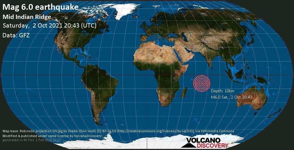
Very strong mag. 6.0 Earthquake - Mid Indian Ridge on Sunday, Oct 3, 2021, at 12:43 am (GMT +4) Very strong mag. 6.0 Earthquake - Mid Indian Ridge on Sunday, Oct 3, 2021, at 12:43 am (GMT +4)
Very strong magnitude 6.0 earthquake at 10 km depth
2 Oct 20:53 UTC: First to report: GFZ after 10 minutes.
2 Oct 20:54: Magnitude recalculated from 5.6 to 5.5. Epicenter location corrected by 2.5 km (1.5 mi) towards ESE.
2 Oct 21:02: Magnitude recalculated from 5.5 to 5.9. Epicenter location corrected by 3.3 km (2 mi) towards W.
2 Oct 21:09: Magnitude recalculated from 5.9 to 6.0.

Earthquake details

Date & timeOct 2, 2021 20:43:39 UTC
Local time at epicenterSunday, Oct 3, 2021, at 12:43 am (GMT +4)
StatusConfirmed (manually revised)
Magnitude6.0
Depth10 km
Epicenter latitude / longitude9.22°S / 67.16°EInternational Territory (not near any country)
Seismic antipode9.22°N / 112.84°W
Shaking intensityVI Strong shaking near epicenter
Felt0 reports
Primary data sourceGFZ (German Research Centre for Geosciences)
Weather at epicenter at time of quakeFew Clouds 26.2°C (79 F), humidity: 71%, wind: 8 m/s (16 kts) from ESE
Estimated seismic energy released6.3 x 1013 joules (17.5 gigawatt hours, equivalent to 15080 tons of TNT or 0.9 atomic bombs!) | about seismic energy
[smaller] [bigger]

Nearby places

The closest larger town where the quake might have been felt is Île Lubine, a town with 15 inhabitants in the British Indian Ocean Territory, in 540 km (336 mi) distance northeast of the epicenter. People likely experienced weak shaking there.
The following table shows some of the places that might have been affected (or not) by the shaking.
Distance Place Max. shaking intensity(*) Region Country
540 km (336 mi)
NE of epicenter
Île Lubine
(pop: 15)
III: Weak
British Indian Ocean Territory
Notes:
(*) Shaking intensity according to the Modified Mercalli Intensity Scale (MMI) and estimated using seismic models.

User-reports for this quake (3)

We received 3 reports for this quake.
User reports estimate the perceived ground shaking intensity according to the MMI (Modified Mercalli Intensity) scale.
Contribute:
Leave a comment if you find a particular report interesting or want to add to it.
Flag as inappropriate.
Mark as helpful or interesting.
Send your own user report!
Translate
Sleeping / not felt : I didn't feel.  
  • Where's Sleeping?
Perth / not felt
Society Hill SC / not felt

What is Intensity and the Mercalli Intensity Scale?


The amount of shaking that occurs on the surface due to an earthquake is called the intensity. It is commonly measured on the so-called Modified Mercalli Intensity Scale (MMI) ranging from 1 (not felt) to 10 (extreme shaking), and given in Roman numerals as I,II,...IX, X, and often displayed with color codes ranging from light blue to dark red.
Earthquake intensity depends mainly on the magnitude and depth of the quake as well as the distance from the epicenter: The further away, the less shaking intensity occurs.
Read more about the MMI scale!

Compare Quake Data

Data for the same earthquake as reported by different agencies

The more agencies report about the same quake and post similar data, the more confidence you can have in the data. It takes normally up to a few hours until earthquake parameters are calculated with near-optimum precision.
Mag Depth Time GMT
2021-10-2
Epicenter Agency
6.0 10 km
6.2 mi
(*)
20:43:39 Mid Indian Ridge GFZ (German Research Centre for Geosciences)
6.0 60 km
37 mi
20:43:45 MID-INDIAN RIDGE
3.3 km (2.1 mi) epicenter difference with GFZ
EMSC (European-Mediterranean Seismological Centre)
5.4 10 km
6.2 mi
(*)
20:43:41 Near Port Louis
14 km (8.7 mi) epicenter difference with GFZ
RENASS (Réseau National de Surveillance Sismique (RéNaSS))
5.7 38 km
24 mi
20:43:43 Mid Indian Ridge
12 km (7.4 mi) epicenter difference with GFZ
BMKG (Meteorological, Climatological, and Geophysical Agency of Indonesia)
6.0 10 km
6.2 mi
(*)
20:43:40 Mid-Indian Ridge
12 km (7.5 mi) epicenter difference with GFZ
USGS (United States Geological Survey)
5.9 33 km
20 mi
20:43:43 Mid Indian Ridge
2.6 km (1.6 mi) epicenter difference with GFZ
GeoAu (Geoscience Australia )
Notes:
(*) A depth given as 10 km often means that the the depth of the quake could not determined with sufficient accuracy.

Seismograms

Seismic station: Diego Garcia, Chagos Islands, Indian Ocean (DGAR/II network) | Distance from quake: 616 km / 383 mi | Show on map | Station Info
Seismic station Diego Garcia, Chagos Islands, Indian Ocean: vertical movement plot around time of quake (source: IRIS/BUD)
Seismogram (vertical component) around time of quake. Thin dotted red line indicates time of quake. Seismic waves arrive some time later, depending on distance. Bandpass filter applied: 0.02-5.0 Hz. Source: IRIS Buffer of Uniform Data (BUD) webtool
Show more

Aftershocks for this quake

No aftershocks have been recorded so far. When aftershocks are detected, we will update this section.

What are aftershocks?


Larger earthquakes (above magnitude 5 or so) such as this one are usually followed by smaller ones known as aftershocks that occur in the same area during the days, weeks, months or even years after the main shock.
[More info]

What about this quake?


Based on its magnitude, the fault that was active during the quake likely ruptured beneath a surface of approx. 100 km2 (=39 sqare miles) as a first-order estimate. The length of the rupture zone thus was probably around 17 km (11 mi).
[More info]


Recorded aftershocks, latest first (0 quake)

Date and Time GMTMag
Depth
DistanceRegionDetails
Oct 3, 2021 12:43 am (GMT +4)
3 years ago
6.0

10 km
0 km - This quakeMid Indian Ridge
Main Shock (this quake)
More

Map of aftershocks

Earthquake statistics

Average number of earthquakes

Based on data from the past 54 years and our earthquake archive back to 1900, there are about 2.9 quakes on average per year in the area near the epicenter of this quake (within 100 km/61 mi):
  • Mag. 6 or higher: 0.02 quakes per year (or 1 quake every 62.5 years)
  • Mag. 5 or higher: 0.65 quakes per year (or 1 quake every 1.5 years)
  • Mag. 4 or higher: 1.83 quakes per year
  • Mag. 3 or higher: 1.83 quakes per year
  • Mag. 2 or higher: 1.83 quakes per year
The area where this quake occurred has a high level of seismic activity. It has had at least 2 quakes above magnitude 6 since 1900, which suggests that larger earthquakes of this size occur infrequently, probably on average approximately every 60 to 65 years.

Number of quakes per year

Previous quakes in the same area of this earthquake

Map of earlier quakes in the area of this quake

[smaller] [bigger]

Map to embed or share

Try our free app!
Volcanoes & Earthquakes - new app for Android
Android | iOS version
Why is there advertising on this site?

Support us - Help us upgrade our services!

We truly love working to bring you the latest volcano and earthquake data from around the world. Maintaining our website and our free apps does require, however, considerable time and resources.
We need financing to increase hard- and software capacity as well as support our editor team. We're aiming to achieve uninterrupted service wherever an earthquake or volcano eruption unfolds, and your donations can make it happen! Every donation will be highly appreciated. If you find the information useful and would like to support our team in integrating further features, write great content, and in upgrading our soft- and hardware, please make a donation (PayPal or Online credit card payment).

Planned features:Thanks to your past donations, these features have been added recently:
Download and Upgrade the Volcanoes & Earthquakes app to get one of the fastest seismic and volcano alerts online:
Android | IOS
Thank you!
Sources: VolcanoDiscovery / VolcanoAdventures and other sources as noted.
Use of material: Most text and images on our websites are owned by us. Re-use is generally not permitted without authorization. Contact us for licensing rights.
Volcanoes & Earthquakes
VolcanoDiscovery Home
Volcanoes | Earthquakes | Photos | Volcano News | App
Adventure & Study Travel
Tours to Volcanoes and Volcanic Areas: walking tours, photo tours, study tours
Tours & Dates | FAQ | About us
Get our newsletter!
Company info
Contact | Legal info | Terms & conditions
Follow us
Follow us on facebook Follow us on Instagram Follow us on Twitter Visit our Youtube channel
EN | DE | EL | ES | FR | IT | RU
VolcanoDiscovery GmbH, Germany, Reg. nr.: HRB 103744, EU Tax Id: DE 297 465 123 owned and created by
Dr. Tom Pfeiffer, volcanologist, volcano photographer, tour organizer member of
IAVCEI
IAVCEI
Vulkanologische Gesellschaft
Volcanological Society
Ecotourism Greece
Ecotourism Greece
RUV insurance
Insured by R+V
VolcanoDiscovery © 2004- All Rights Reserved | Privacy - Cookie Settings