SEARCH
| Latest See all | Mag. 1.8 earthquake Denali - Alaska, United States - |
| Strongest past 48 hours | Mag. 4.6 142 mi east of Sand Point - Alaska, United States - |
Date and Time | Mag Depth | Nearest Volcano | Location | Details | Map |
|---|---|---|---|---|---|
| Apr 20, 02:12 am (Anchorage) | 1.8 93 km | Info | |||
| Apr 20, 01:07 am (Anchorage) | 3.0 83 km | Info | |||
| Apr 20, 12:46 am (Anchorage) | 1.6 85 km | Info | |||
| Apr 20, 12:22 am (Anchorage) | 2.1 20 km | Info | |||
| Apr 19, 11:39 pm (Anchorage) | 3.2 71 km | 9 km (5.6 mi) to the NE | Info | ||
| Apr 19, 11:12 pm (Yakutat) | 1.6 3.6 km | Info | |||
| Apr 19, 11:00 pm (Anchorage) | 1.3 0 km | Info | |||
| Apr 19, 10:17 pm (Anchorage) | 1.4 35 km | Info | |||
| Apr 19, 09:33 pm (Anchorage) | 1.5 6.5 km | Info | |||
| Apr 19, 08:44 pm (Anchorage) | 1.9 14 km | Info | |||
| Apr 19, 07:48 pm (Anchorage) | 1.3 0 km | Info |
| or | ||
Look up quakes! | ||


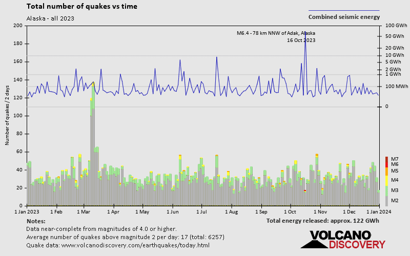
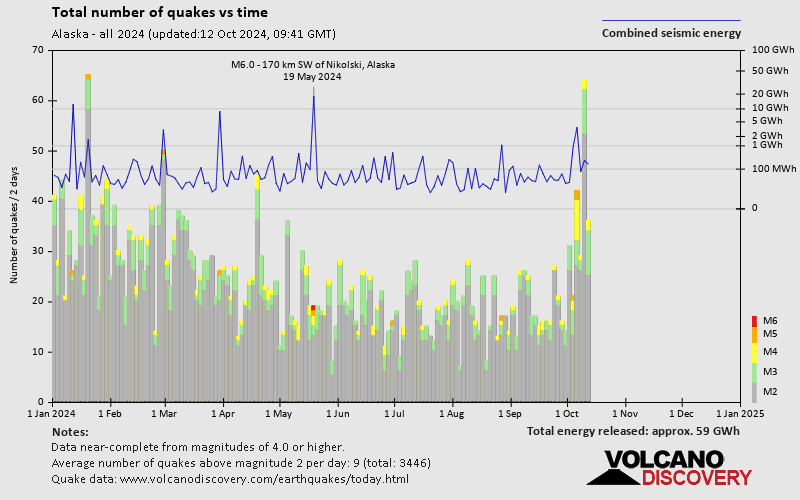
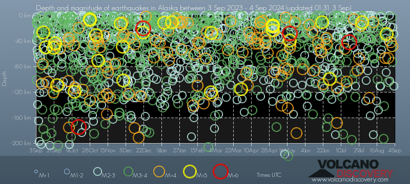
Alaska has a very high level of seismic activity. Based on data from the past 14 years and our earthquake archive back to 1900, there are about 22,000 quakes on average per year in Alaska and the Aleutian Islands. Alaska has had at least 14 quakes above magnitude 8 since 1900, which suggests that larger earthquakes of this size occur infrequently, probably on average approximately every 5 to 10 years.
On average, Alaska has about 1,000 quakes of magnitude 3 or higher per year (Mag 4+: 201 quakes per year, Mag 5+: 41 quakes per year, Mag 6+: 7.2 quakes per year).
The last earthquake in Alaska and the Aleutian Islands occurred 52 minutes ago and had a magnitude of 1.8:
A light magnitude 1.8 earthquake hit 194 km (121 mi) away from Fairbanks, Alaska, ![]() United States, in the early morning of Saturday, Apr 20, 2024 at 2.12 am local time (America/Anchorage GMT -8). The quake had a moderate depth of 93 km (58 mi) and was too small to be felt by people.
United States, in the early morning of Saturday, Apr 20, 2024 at 2.12 am local time (America/Anchorage GMT -8). The quake had a moderate depth of 93 km (58 mi) and was too small to be felt by people.
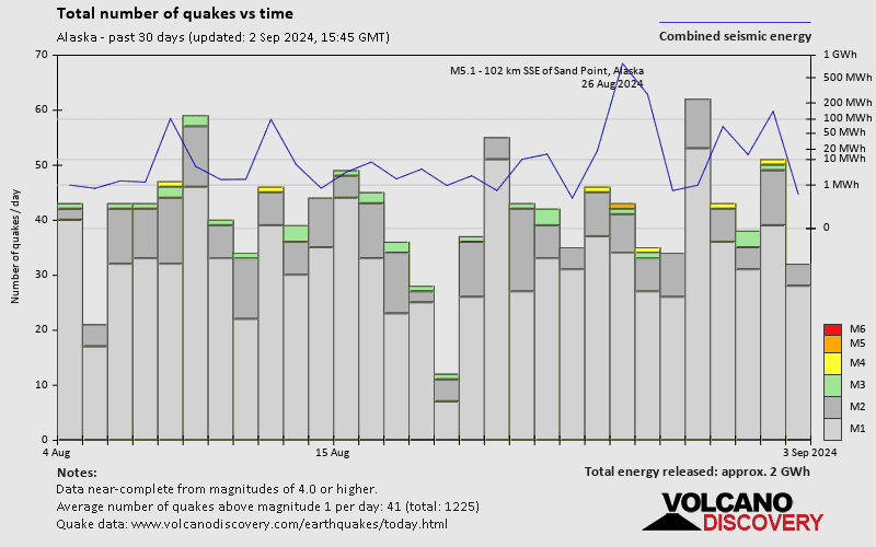
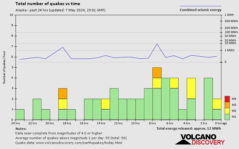
In the past 48 hours, Alaska and the Aleutian Islands has had 3 quakes of magnitude 4.0 or above, 9 quakes between 3.0 and 4.0, and 24 quakes between 2.0 and 3.0. There were also 105 quakes below magnitude 2.0 which people don't normally feel.
The strongest earthquake in Alaska and the Aleutian Islands in the past 48 hours had a magnitude of 4.6 and occurred 1 day 4 hours ago:
A strong magnitude 4.6 earthquake occurred in the Gulf of Alaska near the coast of ![]() United States late in the evening of Thursday, Apr 18, 2024 at 10.27 pm local time (GMT -9). The quake had a very shallow depth of 15.8 km (10 mi) and was not felt (or at least not reported so).
United States late in the evening of Thursday, Apr 18, 2024 at 10.27 pm local time (GMT -9). The quake had a very shallow depth of 15.8 km (10 mi) and was not felt (or at least not reported so).
Date and Time | Mag Depth | ###DIST_LABEL### | Location | Details | Map |
|---|