SEARCH
| Latest See all | Mag. 3.2 earthquake North Pacific Ocean - British Columbia, Canada - |
| Strongest past 30 days | Mag. 3.4 Canada: 13 km NW of Yuquot - BC - Mar 31, 2024 - |
Date and Time | Mag Depth | Nearest Volcano | Location | Details | Map |
|---|---|---|---|---|---|
| Apr 23, 11:43 pm (GMT -9) | 3.2 24 km | 26 km (16 mi) to the SW | Info | ||
| Tuesday, April 23, 2024 GMT (1 quake) | |||||
| Apr 22, 05:32 pm (Los Angeles) | 1.5 16 km | 32 km (20 mi) to the S | Info | ||
| Monday, April 22, 2024 GMT (2 quakes) | |||||
| Apr 22, 12:12 pm (Vancouver) | 1.1 0.8 km | 10 km (6.2 mi) to the S | Info | ||
| Apr 22, 10:03 am (Vancouver) | 1.3 0.5 km | 6 km (3.7 mi) to the S | Info | ||
| Sunday, April 21, 2024 GMT (1 quake) | |||||
| Apr 21, 10:27 am (Los Angeles) | 1.2 18 km | 38 km (24 mi) to the S | Info | ||
| Saturday, April 20, 2024 GMT (1 quake) | |||||
| Apr 19, 05:15 pm (Vancouver) | 1.7 17 km | 9 km (5.6 mi) to the W | Info | ||
| Friday, April 19, 2024 GMT (2 quakes) | |||||
| Apr 19, 08:58 am (GMT -9) | 2.0 10 km | 78 km (48 mi) to the S | Info | ||
| Apr 19, 08:57 am (GMT -9) | 2.1 10 km | 77 km (48 mi) to the S | Info | ||
| Thursday, April 18, 2024 GMT (3 quakes) | |||||
| Apr 18, 11:18 am (Vancouver) | 2.6 15 km | 18 km (11 mi) to the W | Info | ||
| Apr 17, 06:39 pm (GMT -8) | 1.5 24 km | 29 km (18 mi) to the S | Info | ||
| Apr 17, 05:02 pm (Vancouver) | 0.8 17 km | 9 km (5.6 mi) to the W | Info | ||


| or | ||
Look up quakes! | ||
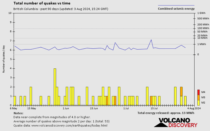
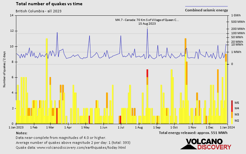
British Columbia has relatively few earthquakes. Based on data from the past 54 years and our earthquake archive back to 1900, there are about 702 quakes on average per year in or near British Columbia. However, British Columbia has had at least 5 quakes above magnitude 7 since 1900, which suggests that larger earthquakes of this size occur infrequently, probably on average approximately every 20 to 25 years.
On average, British Columbia has about 36.6 quakes of magnitude 3 or higher per year.
The last earthquake in or near British Columbia occurred 15 hours ago and had a magnitude of 3.2:
A light magnitude 3.2 earthquake occurred in the North Pacific Ocean near Marshall Island island, Canada, late in the evening of Tuesday, Apr 23, 2024 at 11.43 pm local time (GMT -9). The quake had a very shallow depth of 24 km (15 mi) and was not felt (or at least not reported so).
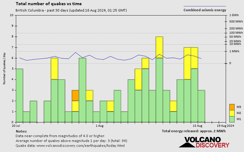
In the past 30 days, British Columbia has had 5 quakes of magnitude 3.0 or above and 8 quakes between 2.0 and 3.0. There have been also 40 quakes below magnitude 2.0 which people don't normally feel.
The strongest earthquake in or near British Columbia in the past 30 days had a magnitude of 3.4 and occurred 3 weeks ago:
A light magnitude 3.4 earthquake hit 48 km (30 mi) away from Vernon, British Columbia, ![]() Canada, in the afternoon of Sunday, Mar 31, 2024 at 5.17 pm local time (America/Vancouver GMT -7). The quake had a shallow depth of 36 km (22 mi) and was not felt (or at least not reported so).
Canada, in the afternoon of Sunday, Mar 31, 2024 at 5.17 pm local time (America/Vancouver GMT -7). The quake had a shallow depth of 36 km (22 mi) and was not felt (or at least not reported so).
Date and Time | Mag Depth | ###DIST_LABEL### | Location | Details | Map |
|---|