SEARCH
| Latest today See all | Mag. 3.0 earthquake 20 km west of David - Chiriqui, Panama - |
| Latest felt | Mag. 4.1 earthquake 34 km northwest of San Pedro Sula - Cortes, Honduras - |
| Strongest today | Mag. 4.2 82 km east of Loreto - Baja California Sur, Mexico - |
Date and Time | Mag Depth | Nearest Volcano | Location | Details | Map |
|---|---|---|---|---|---|
| Apr 23, 06:26 am (Panama) | 3.0 33 km | Info | |||
| Apr 23, 05:41 am (Chicago) | 2.0 2.8 km | Info | |||
| Apr 23, 04:12 am (Managua) | 2.0 5 km | Info | |||
| Apr 23, 04:11 am (GMT -6) | 1.8 21 km | Info | |||
| Apr 23, 03:08 am (Los Angeles) | 0.9 10.5 km | Info | |||
| Apr 23, 04:56 am (Chicago) | 2.4 4.7 km | Info | |||
| Apr 23, 02:27 am (Los Angeles) | 1.3 4.9 km | Info | |||
| Apr 23, 03:05 am (GMT -6) | 2.7 18 km | Info | |||
| Apr 23, 03:57 am (Chicago) | 2.1 4.2 km | Info | |||
| Apr 23, 01:24 am (Los Angeles) | 0.6 13 km | Info | |||
| Apr 23, 03:05 am (Chicago) | 3.0 9 km | Info |

| or | ||
Look up quakes! | ||


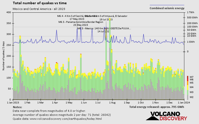
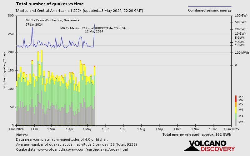
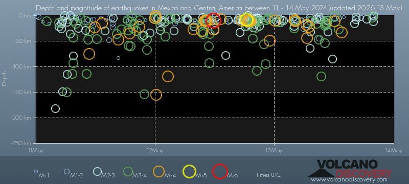
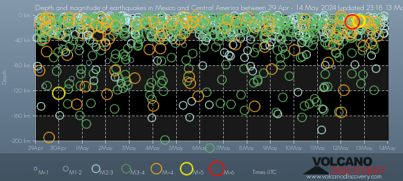
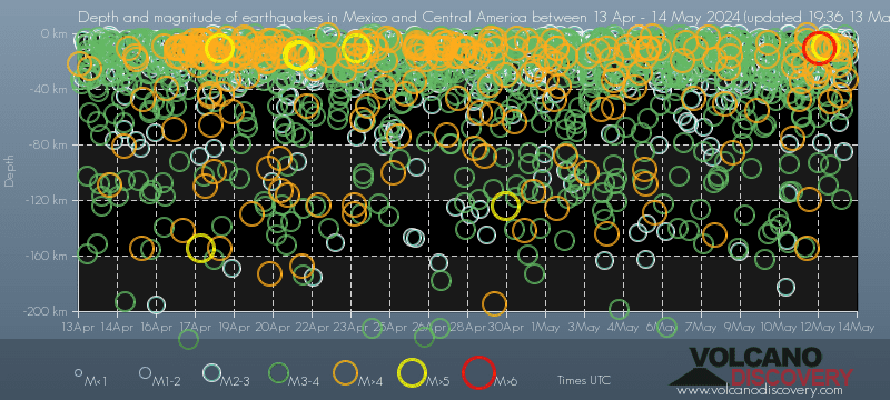
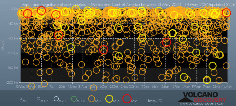
Mexico and Central America has a high level of seismic activity. Based on data from the past 14 years and our earthquake archive back to 1900, there are about 31,000 quakes on average per year in or near Mexico and Central America. Mexico and Central America has had at least 4 quakes above magnitude 8 since 1900, which suggests that larger earthquakes of this size occur infrequently, probably on average approximately every 30 to 35 years.
On average, Mexico and Central America has about 14,000 quakes of magnitude 3 or higher per year (Mag 4+: 2,600 quakes per year, Mag 5+: 80 quakes per year, Mag 6+: 7 quakes per year).
The last earthquake in Mexico and Central America occurred 27 minutes ago and had a magnitude of 3.0:
A light magnitude 3.0 earthquake hit 19.9 km (12 mi) away from David, Chiriqui, ![]() Panama, in the early morning of Tuesday, Apr 23, 2024 at 6.26 am local time (America/Panama GMT -5). The quake had a very shallow depth of 33 km (20 mi) and was not felt (or at least not reported so).
Panama, in the early morning of Tuesday, Apr 23, 2024 at 6.26 am local time (America/Panama GMT -5). The quake had a very shallow depth of 33 km (20 mi) and was not felt (or at least not reported so).
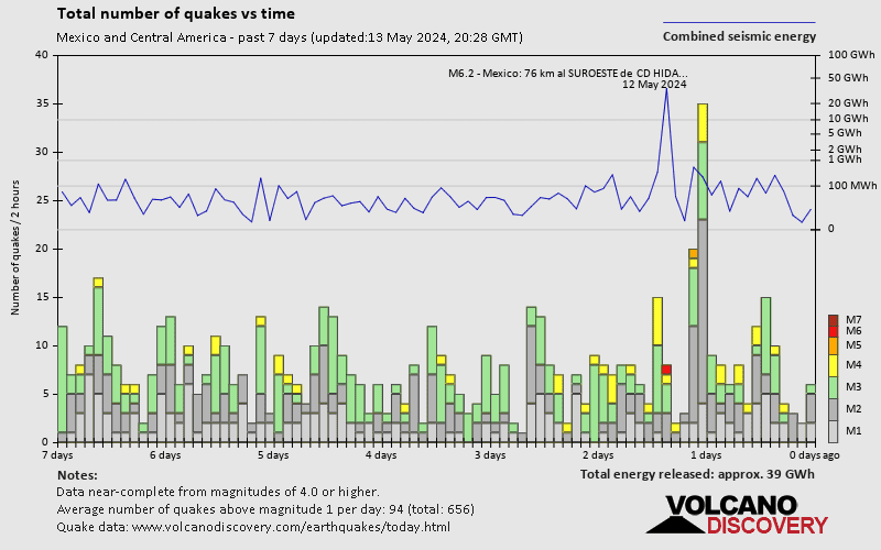
In the past 24 hours, Mexico and Central America was shaken by 3 quakes of magnitude 4.0 or above, 24 quakes between 3.0 and 4.0, and 16 quakes between 2.0 and 3.0. There were also 32 quakes below magnitude 2.0 which people don't normally feel.
The strongest earthquake in Mexico and Central America today had a magnitude of 4.2 and occurred 12 hours ago:
A moderate magnitude 4.2 earthquake occurred in the Gulf of California near the coast of ![]() Mexico in the afternoon of Monday, Apr 22, 2024 at 4.36 pm local time (GMT -7). The quake had a very shallow depth of 15 km (9 mi) and was not felt (or at least not reported so).
Mexico in the afternoon of Monday, Apr 22, 2024 at 4.36 pm local time (GMT -7). The quake had a very shallow depth of 15 km (9 mi) and was not felt (or at least not reported so).
Date and Time | Mag Depth | ###DIST_LABEL### | Location | Details | Map |
|---|