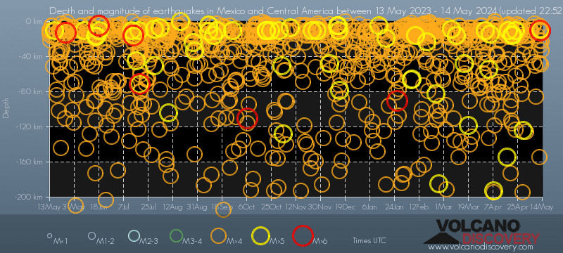
Contact | RSS | EN | DE | EL | ES | FR | IT | RU

Largest earthquakes in or near Mexico and Central America on record since 1900 - list, stats and map

Updated: Apr 25, 2024 01:32 GMT -
Since 1900, Mexico and Central America has had 135 quakes of magnitudes up to 8.1:
  • 6 quakes above magnitude 8
  • 129 quakes between magnitude 7 and 8
Number of quakes per year
Latest: Mag. 7.7 Earthquake 63 Km Al SUR De COALCOMAN, MICH -
Strongest: Mag. 8.1 Earthquake Near Coast of Chiapas, Mexico -
[smaller] [bigger]
Filter by magnitude:
all
7.0+
8.0+
Filter by age:
all
1y
3y
5y
10y
30y
Showing quakes since 1900magnitude 7.3 or higher (135 quakes):
Largest earthquakes in or near Mexico and Central America on record since 1900 - list, stats and map
Date and TimeMag
Depth
Nearest VolcanoLocationDetailsMap
Sep 19, 2022 01:05 pm (Mexico City)
7.7

15 km
63 Km Al SUR De COALCOMAN, MICH 1272 reportsInfo
Wednesday, September 8, 2021 GMT (1 quake)
Sep 7, 2021 08:47 pm (Mexico City)
7.1

10 km
North Pacific Ocean, 8 km south of Acapulco, Guerrero, Mexico 405 reportsInfo
Tuesday, June 23, 2020 GMT (1 quake)
Jun 23, 2020 10:29 am (Mexico City)
7.3

35 km
15 km northeast of Merced del Potrero, Oaxaca, Mexico 469 reportsInfo
Tuesday, January 28, 2020 GMT (1 quake)
Jan 28, 2020 02:10 pm (GMT -5)
7.7

15 km
123 km NNW of Lucea, Jamaica 948 reportsInfo
Friday, February 16, 2018 GMT (1 quake)
Feb 16, 2018 05:39 pm (Mexico City)
7.0

10 km
Oaxaca, Mexico 276 reportsInfo
Wednesday, January 10, 2018 GMT (1 quake)
Jan 9, 2018 08:51 pm (GMT -6)
7.5

10 km
North of Honduras 133 reportsInfo
Tuesday, September 19, 2017 GMT (1 quake)
Sep 19, 2017 01:14 pm (Mexico City)
7.1

56 km
1.7 km south of Casa Blanca (Cuyotliapa), Puebla, Mexico 345 reportsInfo
Friday, September 8, 2017 GMT (1 quake)
Sep 7, 2017 10:49 pm (GMT -6)
8.1

60 km
North Pacific Ocean, 88 km southwest of Topon, Chiapas, Mexico 317 reportsInfo
Tuesday, October 14, 2014 GMT (1 quake)
Oct 13, 2014 09:51 pm (GMT -6)
7.2

43 km
North Pacific Ocean, 66 km west of Jiquilillo, Chinandega, Nicaragua 88 reportsInfo
Friday, April 18, 2014 GMT (1 quake)
Apr 18, 2014 08:27 am (Mexico City)
7.2

24 km
26 km southwest of La Laguna, Guerrero, Mexico 119 reportsInfo
Wednesday, November 7, 2012 GMT (1 quake)
Nov 7, 2012 10:35 am (GMT -6)
7.4

24 km
North Pacific Ocean, 34 km south of Champerico, Retalhuleu, Guatemala 8 reportsInfo
Show more
About these data
Estimated combined seismic energy released: 1.6 x 10¹⁸ joules (4.5 x 10⁵ gigawatt hours, equivalent to 3.9 x 10⁸ tons of TNT or 24230.9 atomic bombs!) | about seismic energy

Earthquake Catalog - Look up past earthquakes

Look up past earthquakes in this area by date or date range:
or
Look up quakes!
Felt a quake? Report it!
Show quakes near me!

Embed or share standalone map

You can use the standalone version of our interactive earthquake map or embed it on your website:

Largest Quakes in or near Mexico and Central America

Date and TimeMag
Depth
###DIST_LABEL###LocationDetailsMap

Map of largest quakes in or near Mexico and Central America

[smaller] [bigger]

On this page:

Try our free app!
Volcanoes & Earthquakes - new app for Android
Android | iOS version
Why is there advertising on this site?

Support us - Help us upgrade our services!

We truly love working to bring you the latest volcano and earthquake data from around the world. Maintaining our website and our free apps does require, however, considerable time and resources.
We need financing to increase hard- and software capacity as well as support our editor team. We're aiming to achieve uninterrupted service wherever an earthquake or volcano eruption unfolds, and your donations can make it happen! Every donation will be highly appreciated. If you find the information useful and would like to support our team in integrating further features, write great content, and in upgrading our soft- and hardware, please make a donation (PayPal or Online credit card payment).

Planned features:Thanks to your past donations, these features have been added recently:
Download and Upgrade the Volcanoes & Earthquakes app to get one of the fastest seismic and volcano alerts online:
Android | IOS
Thank you!
Sources: VolcanoDiscovery / VolcanoAdventures and other sources as noted.
Use of material: Most text and images on our websites are owned by us. Re-use is generally not permitted without authorization. Contact us for licensing rights.
Volcanoes & Earthquakes
VolcanoDiscovery Home
Volcanoes | Earthquakes | Photos | Volcano News | App
Adventure & Study Travel
Tours to Volcanoes and Volcanic Areas: walking tours, photo tours, study tours
Tours & Dates | FAQ | About us
Get our newsletter!
Company info
Contact | Legal info | Terms & conditions
Follow us
Follow us on facebook Follow us on Instagram Follow us on Twitter Visit our Youtube channel
EN | DE | EL | ES | FR | IT | RU
VolcanoDiscovery GmbH, Germany, Reg. nr.: HRB 103744, EU Tax Id: DE 297 465 123 owned and created by
Dr. Tom Pfeiffer, volcanologist, volcano photographer, tour organizer member of
IAVCEI
IAVCEI
Vulkanologische Gesellschaft
Volcanological Society
Ecotourism Greece
Ecotourism Greece
RUV insurance
Insured by R+V
VolcanoDiscovery © 2004- All Rights Reserved | Privacy - Cookie Settings