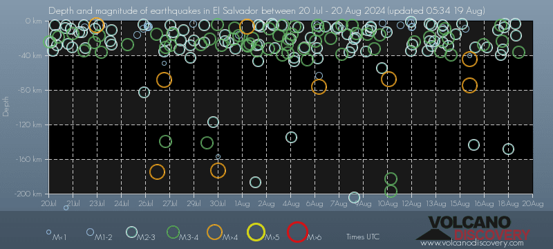
Contact | RSS | EN | DE | EL | ES | FR | IT | RU

Largest earthquakes in or near El Salvador on record since 1900 - list, stats and map

Updated: Apr 25, 2024 19:42 GMT -
Since 1900, El Salvador has had 95 quakes of magnitudes up to 7.9:
  • 12 quakes above magnitude 7
  • 83 quakes between magnitude 6 and 7
Number of quakes per year
Latest: Mag. 6.1 Earthquake 15 km W of Taxisco, Guatemala -
Strongest: Mag. 7.9 Earthquake Chalatenango, 40 km NE of San Salvador, San Salvador, n/a -
[smaller] [bigger]
Filter by magnitude:
all
7.0+
Filter by age:
all
1y
3y
5y
10y
30y
Showing quakes since 1900magnitude 7 or higher, within up to 100 km (62 mi) distance (95 quakes):
Largest earthquakes in or near El Salvador on record since 1900 - list, stats and map
Date and TimeMag
Depth
Nearest VolcanoLocationDetailsMap
Jan 26, 11:52 pm (Guatemala)
6.1

90 km
54 km (34 mi) to the W 15 km W of Taxisco, Guatemala 263 reportsInfo
Wednesday, July 19, 2023 GMT (1 quake)
Jul 18, 2023 06:22 pm (GMT -6)
6.5

71 km
39 km (24 mi) to the SE 43 km S of Intipucá, El Salvador 343 reportsInfo
Thursday, May 30, 2019 GMT (1 quake)
May 30, 2019 03:03 am (GMT -6)
6.6

58 km
23 km (14 mi) to the SW 32 km S of La Libertad, El Salvador 324 reportsInfo
Thursday, June 22, 2017 GMT (1 quake)
Jun 22, 2017 06:31 am (Guatemala)
6.8

32 km
68 km (42 mi) to the W Near Coast of Guatemala 47 reportsInfo
Friday, May 12, 2017 GMT (1 quake)
May 12, 2017 04:41 am (GMT -6)
6.0

10 km
72 km (45 mi) to the SW Off Coast of Central America 10 reportsInfo
Thursday, November 24, 2016 GMT (1 quake)
Nov 24, 2016 12:43 pm (GMT -6)
6.9

10 km
145 km (90 mi) to the S Off Coast of Central America 29 reportsInfo
Friday, June 10, 2016 GMT (1 quake)
Jun 9, 2016 09:25 pm (Managua)
6.0

13 km
85 km (53 mi) to the SE Nicaragua 45 reportsInfo
Tuesday, October 14, 2014 GMT (1 quake)
Oct 13, 2014 09:51 pm (GMT -6)
7.2

43 km
61 km (38 mi) to the SE North Pacific Ocean, 66 km west of Jiquilillo, Chinandega, Nicaragua 88 reportsInfo
Sunday, March 2, 2014 GMT (1 quake)
Mar 2, 2014 03:37 am (GMT -6)
6.2

60 km
60 km (37 mi) to the SE 33 km SW of Jiquilillo, Nicaragua 36 reportsInfo
Monday, March 25, 2013 GMT (1 quake)
Mar 25, 2013 05:02 pm (Guatemala)
6.2

201 km
85 km (53 mi) to the NW 6km NNW of San Jose Pinula, Guatemala 2 reportsInfo
Monday, August 27, 2012 GMT (2 quakes)
Aug 26, 2012 10:37 pm (GMT -6)
7.3

28 km
117 km (73 mi) to the S 111km S of Puerto El Triunfo, El Salvador Info
Show more
About these data
Estimated combined seismic energy released: 1.4 x 10¹⁷ joules (37609 gigawatt hours, equivalent to 3.2 x 10⁷ tons of TNT or 2022.5 atomic bombs!) | about seismic energy

Earthquake Catalog - Look up past earthquakes

Look up past earthquakes in this area by date or date range:
or
Look up quakes!
Felt a quake? Report it!
Show quakes near me!

Embed or share standalone map

You can use the standalone version of our interactive earthquake map or embed it on your website:

Largest Quakes in or near El Salvador

Date and TimeMag
Depth
###DIST_LABEL###LocationDetailsMap

Map of largest quakes in or near El Salvador

[smaller] [bigger]

Earthquakes in or near El Salvador

Quakes in nearby regions

On this page:

Try our free app!
Volcanoes & Earthquakes - new app for Android
Android | iOS version
Why is there advertising on this site?

Support us - Help us upgrade our services!

We truly love working to bring you the latest volcano and earthquake data from around the world. Maintaining our website and our free apps does require, however, considerable time and resources.
We need financing to increase hard- and software capacity as well as support our editor team. We're aiming to achieve uninterrupted service wherever an earthquake or volcano eruption unfolds, and your donations can make it happen! Every donation will be highly appreciated. If you find the information useful and would like to support our team in integrating further features, write great content, and in upgrading our soft- and hardware, please make a donation (PayPal or Online credit card payment).

Planned features:Thanks to your past donations, these features have been added recently:
Download and Upgrade the Volcanoes & Earthquakes app to get one of the fastest seismic and volcano alerts online:
Android | IOS
Thank you!
Sources: VolcanoDiscovery / VolcanoAdventures and other sources as noted.
Use of material: Most text and images on our websites are owned by us. Re-use is generally not permitted without authorization. Contact us for licensing rights.
Volcanoes & Earthquakes
VolcanoDiscovery Home
Volcanoes | Earthquakes | Photos | Volcano News | App
Adventure & Study Travel
Tours to Volcanoes and Volcanic Areas: walking tours, photo tours, study tours
Tours & Dates | FAQ | About us
Get our newsletter!
Company info
Contact | Legal info | Terms & conditions
Follow us
Follow us on facebook Follow us on Instagram Follow us on Twitter Visit our Youtube channel
EN | DE | EL | ES | FR | IT | RU
VolcanoDiscovery GmbH, Germany, Reg. nr.: HRB 103744, EU Tax Id: DE 297 465 123 owned and created by
Dr. Tom Pfeiffer, volcanologist, volcano photographer, tour organizer member of
IAVCEI
IAVCEI
Vulkanologische Gesellschaft
Volcanological Society
Ecotourism Greece
Ecotourism Greece
RUV insurance
Insured by R+V
VolcanoDiscovery © 2004- All Rights Reserved | Privacy - Cookie Settings