SEARCH
| Latest See all | Mag. 1.7 earthquake 15 km east of Dajabon - Dajabon, Dominican Republic - |
| Strongest past 14 days | Mag. 3.8 North Atlantic Ocean - Nord-Ouest, Haiti - Apr 16, 2024 - |
Date and Time | Mag Depth | Nearest Volcano | Location | Details | Map |
|---|---|---|---|---|---|
| Apr 24, 02:59 am (Santo Domingo) | 1.7 19 km | 13 km (8.1 mi) to the NE | Info | ||
| Apr 24, 02:33 am (Port-au-Prince) | 3.6 18 km | 22 km (14 mi) to the W | Info | ||
| Tuesday, April 23, 2024 GMT (5 quakes) | |||||
| Apr 23, 05:03 pm (GMT -5) | 2.6 15 km | 36 km (22 mi) to the NW | Info | ||
| Apr 23, 04:42 pm (GMT -5) | 2.2 30 km | 64 km (40 mi) to the NW | Info | ||
| Apr 23, 04:06 pm (Port-au-Prince) | 2.1 2.3 km | Info | |||
| Apr 23, 06:23 am (Santo Domingo) | 2.8 9 km | 21 km (13 mi) to the SE | Info | ||
| Apr 22, 08:25 pm (Santo Domingo) | 1.5 18 km | Info | |||
| Monday, April 22, 2024 GMT (6 quakes) | |||||
| Apr 22, 02:24 pm (GMT -5) | 2.7 5 km | 25 km (16 mi) to the NW | Info | ||
| Apr 22, 02:00 pm (GMT -4) | 2.6 5 km | 71 km (44 mi) to the NE | Info | ||
| Apr 22, 12:00 pm (Port-au-Prince) | 2.1 0 km | Info | |||
| Apr 22, 02:29 am (Santo Domingo) | 2.1 17 km | 24 km (15 mi) to the SE | Info | ||
| or | ||
Look up quakes! | ||

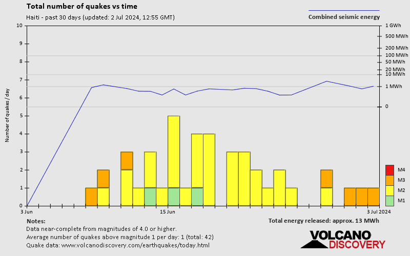

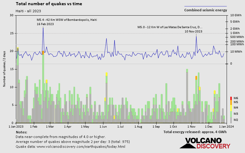
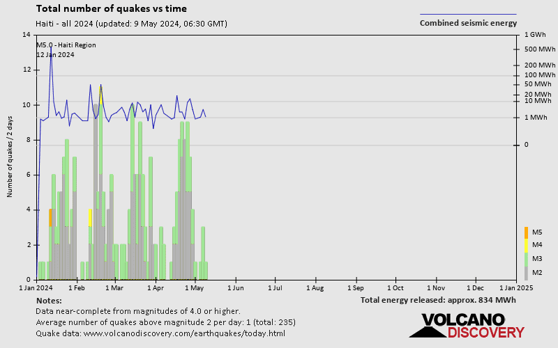
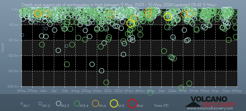
Haiti has a high level of seismic activity. Based on data from the past 14 years and our earthquake archive back to 1900, there are about 641 quakes on average per year in Haiti. Haiti has had at least 2 quakes above magnitude 7 since 1900, which suggests that larger earthquakes of this size occur infrequently, probably on average approximately every 60 to 65 years.
On average, Haiti has about 305 quakes of magnitude 3 or higher per year (Mag 4+: 24.4 quakes per year, Mag 5+: 2.2 quakes per year).
The last earthquake in Haiti occurred 4 hours ago and had a magnitude of 1.7:
A light magnitude 1.7 earthquake hit 14.7 km (9 mi) away from Dajabon, Dajabon, ![]() Dominican Republic, in the early morning of Wednesday, Apr 24, 2024 at 2.59 am local time (America/Santo Domingo GMT -4). The quake had a very shallow depth of 19.4 km (12 mi) and was too small to be felt by people.
Dominican Republic, in the early morning of Wednesday, Apr 24, 2024 at 2.59 am local time (America/Santo Domingo GMT -4). The quake had a very shallow depth of 19.4 km (12 mi) and was too small to be felt by people.
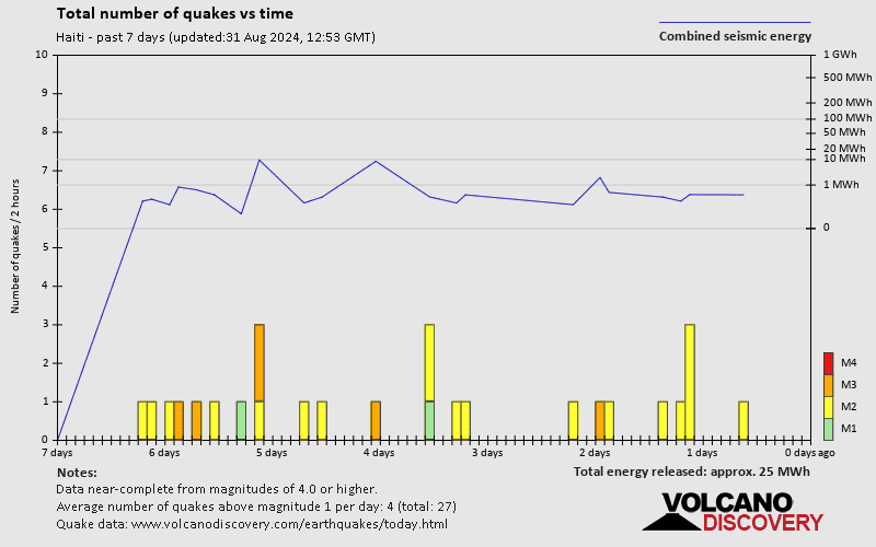
In the past 14 days, Haiti has had 11 quakes of magnitude 3.0 or above and 24 quakes between 2.0 and 3.0. There have been also 10 quakes below magnitude 2.0 which people don't normally feel.
The strongest earthquake in Haiti in the past 14 days had a magnitude of 3.8 and occurred 8 days ago:
A moderate magnitude 3.8 earthquake occurred in the North Atlantic Ocean near the coast of ![]() Haiti in the early morning of Tuesday, Apr 16, 2024 at 5.35 am local time (America/Port-au-Prince GMT -4). The quake had a shallow depth of 48 km (30 mi) and was not felt (or at least not reported so).
Haiti in the early morning of Tuesday, Apr 16, 2024 at 5.35 am local time (America/Port-au-Prince GMT -4). The quake had a shallow depth of 48 km (30 mi) and was not felt (or at least not reported so).
Date and Time | Mag Depth | ###DIST_LABEL### | Location | Details | Map |
|---|