SEARCH
| Latest today See all | Mag. 2.1 earthquake 6.9 mi northeast of Pāhala - Hawaii, United States - |
| Strongest today | Mag. 2.4 North Pacific Ocean - Hawaii, United States - |
Date and Time | Mag Depth | Nearest Volcano | Location | Details | Map |
|---|---|---|---|---|---|
| Apr 22, 09:27 pm (Honolulu) | 2.1 32 km | Info | |||
| Apr 22, 07:34 pm (Honolulu) | 2.0 1.7 km | Info | |||
| Monday, April 22, 2024 GMT (10 quakes) | |||||
| Apr 22, 12:57 pm (Honolulu) | 1.7 9.2 km | Info | |||
| Apr 22, 08:07 am (Honolulu) | 1.7 31 km | Info | |||
| Apr 22, 07:15 am (Honolulu) | 1.8 4.6 km | 5 km (3.1 mi) to the SE | Info | ||
| Apr 22, 04:55 pm (GMT +0) | 2.2 36 km | 13 km (8.1 mi) to the SE | Info | ||
| Apr 22, 06:12 am (Honolulu) | 1.8 2.5 km | Info | |||
| Apr 22, 05:44 am (Honolulu) | 1.8 2.1 km | Info | |||
| Apr 22, 05:41 am (GMT -10) | 2.4 33 km | 14 km (8.7 mi) to the SE | Info | ||
| Apr 22, 05:37 am (Honolulu) | 1.3 1.3 km | Info | |||
| Apr 22, 04:22 am (Honolulu) | 2.0 29 km | Info | |||
| or | ||
Look up quakes! | ||

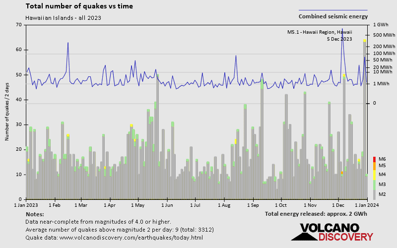
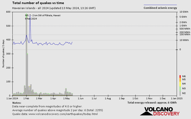
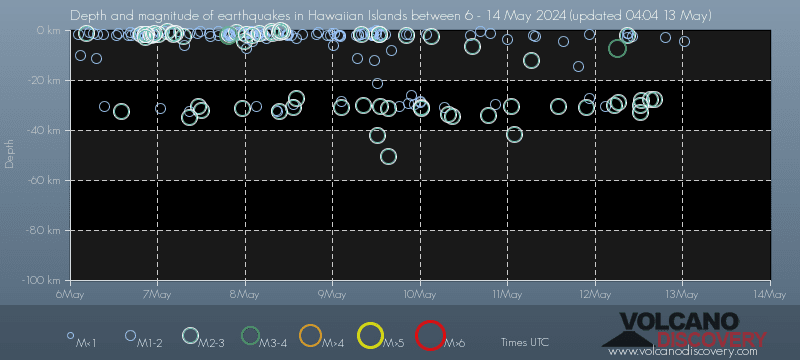
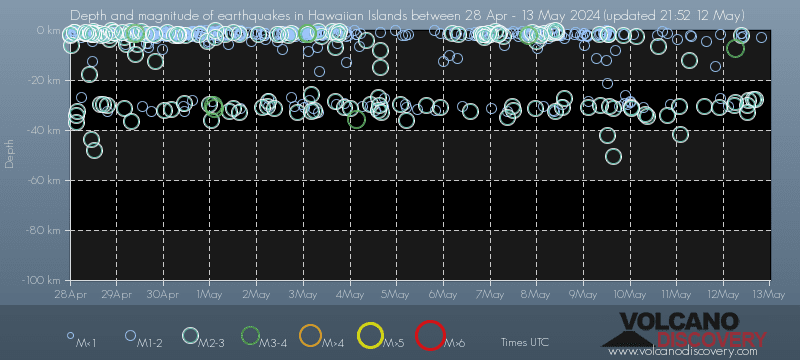
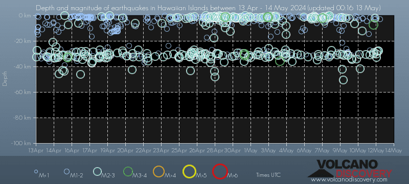
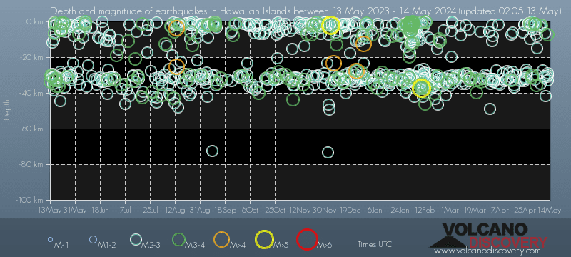
Hawaiian Islands has a high level of seismic activity. Based on data from the past 14 years and our earthquake archive back to 1900, there are about 13,000 quakes on average per year on or near the Hawaiian Islands. Hawaiian Islands has had at least 25 quakes above magnitude 6 since 1900, which suggests that larger earthquakes of this size occur infrequently, probably on average approximately every 1 to 5 years.
On average, Hawaiian Islands has about 602 quakes of magnitude 3 or higher per year (Mag 4+: 21.6 quakes per year, Mag 5+: 4.6 quakes per year).
The last earthquake on or near the Hawaiian Islands occurred 4 hours ago and had a magnitude of 2.1:
A light magnitude 2.1 earthquake hit 11 km (7 mi) away from Pāhala, Hawaii, ![]() United States, in the evening of Monday, Apr 22, 2024 at 9.27 pm local time (Pacific/Honolulu GMT -10). The quake had a very shallow depth of 32 km (20 mi) and was not felt (or at least not reported so).
United States, in the evening of Monday, Apr 22, 2024 at 9.27 pm local time (Pacific/Honolulu GMT -10). The quake had a very shallow depth of 32 km (20 mi) and was not felt (or at least not reported so).
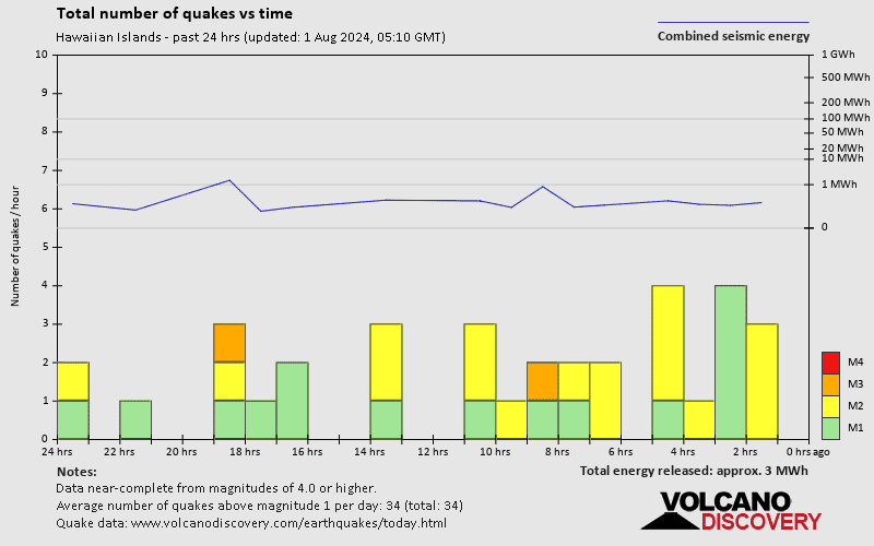
In the past 24 hours, Hawaiian Islands has had 5 quakes of magnitude 2.0 or above. There were also 7 quakes below magnitude 2.0 which people don't normally feel.
The strongest earthquake on or near the Hawaiian Islands today had a magnitude of 2.4 and occurred 20 hours ago:
A light magnitude 2.4 earthquake occurred in the North Pacific Ocean near Hawaii island, USA, in the early morning of Monday, Apr 22, 2024 at 5.41 am local time (GMT -10). The quake had a very shallow depth of 33 km (21 mi) and was not felt (or at least not reported so).
Date and Time | Mag Depth | ###DIST_LABEL### | Location | Details | Map |
|---|