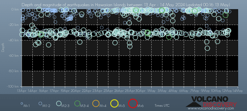
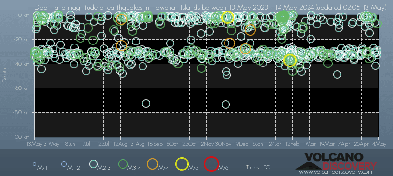
Contact | RSS | EN | DE | EL | ES | FR | IT | RU

Largest earthquakes on or near the Hawaiian Islands on record since 1900 - list, stats and map

Updated: Apr 19, 2024 13:59 GMT -
Since 1900, Hawaiian Islands has had 100 quakes of magnitudes above 4 and up to 6.8:
  • 18 quakes above magnitude 6
  • 19 quakes between magnitude 5 and 6
  • 63 quakes between magnitude 4 and 5
Number of quakes per year
Latest: Mag. 4.6 Earthquake 11 km W of Kalaoa, Hawaii -
Strongest: Mag. 6.8 Earthquake Hawaii region, Hawaii (USA) -
[smaller] [bigger]
Filter by magnitude:
all
6.0+
Filter by age:
all
1y
3y
5y
10y
30y
Showing quakes since 1900magnitude 6.8 or higher, within up to 100 km (62 mi) distance (100 quakes):
Largest earthquakes on or near the Hawaiian Islands on record since 1900 - list, stats and map
Date and TimeMag
Depth
Nearest VolcanoLocationDetailsMap
Nov 24, 1969 09:12 am (Honolulu)
4.6

1 km
3 km (1.9 mi) to the SE 11 km W of Kalaoa, Hawaii Info
Sunday, November 23, 1969 GMT (1 quake)
Nov 22, 1969 02:05 pm (Honolulu)
4.3

16 km
Hawaii region, Hawaii (USA) Info
Monday, November 10, 1969 GMT (1 quake)
Nov 9, 1969 07:12 pm (Honolulu)
4.5

8.3 km
Island of Hawaii, Hawaii Info
Wednesday, September 3, 1969 GMT (1 quake)
Sep 3, 1969 09:40 am (Honolulu)
4.4

29 km
15 km NNE of P?hala, Hawaii Info
Sunday, July 13, 1969 GMT (1 quake)
Jul 13, 1969 01:22 am (Honolulu)
4.4

7.2 km
12 km W of P?hala, Hawaii Info
Saturday, May 10, 1969 GMT (1 quake)
May 9, 1969 03:33 pm (Honolulu)
4.3

12 km
Hawaii region, Hawaii (USA) Info
Monday, February 10, 1969 GMT (1 quake)
Feb 9, 1969 04:24 pm (Honolulu)
4.3

8.1 km
Island of Hawaii, Hawaii Info
Saturday, October 26, 1968 GMT (1 quake)
Oct 25, 1968 02:47 pm (Honolulu)
4.3

33 km
9 km (5.6 mi) to the SE Hawaii region, Hawaii Info
Sunday, April 28, 1968 GMT (1 quake)
Apr 28, 1968 04:09 am (Honolulu)
4.3

21 km
2 km WSW of Volcano, Hawaii Info
Sunday, March 31, 1968 GMT (1 quake)
Mar 31, 1968 12:56 am (GMT -10)
4.7

19 km
57 km (35 mi) to the N Oahu region, Hawaii (USA) Info
Thursday, February 22, 1968 GMT (1 quake)
Feb 22, 1968 09:20 am (GMT -10)
4.6

16 km
45 km (28 mi) to the SE Hawaii region, Hawaii (USA) Info
Show more
About these data
Estimated combined seismic energy released: 4.5 x 10¹⁵ joules (1262 gigawatt hours, equivalent to 1.1 x 10⁶ tons of TNT or 67.9 atomic bombs!) | about seismic energy

Earthquake Catalog - Look up past earthquakes

Look up past earthquakes in this area by date or date range:
or
Look up quakes!
Felt a quake? Report it!
Show quakes near me!

Embed or share standalone map

You can use the standalone version of our interactive earthquake map or embed it on your website:

Largest Quakes on or near the Hawaiian Islands

Date and TimeMag
Depth
###DIST_LABEL###LocationDetailsMap

Map of largest quakes on or near the Hawaiian Islands

[smaller] [bigger]

Quakes in nearby regions

On this page:

Try our free app!
Volcanoes & Earthquakes - new app for Android
Android | iOS version
Why is there advertising on this site?

Support us - Help us upgrade our services!

We truly love working to bring you the latest volcano and earthquake data from around the world. Maintaining our website and our free apps does require, however, considerable time and resources.
We need financing to increase hard- and software capacity as well as support our editor team. We're aiming to achieve uninterrupted service wherever an earthquake or volcano eruption unfolds, and your donations can make it happen! Every donation will be highly appreciated. If you find the information useful and would like to support our team in integrating further features, write great content, and in upgrading our soft- and hardware, please make a donation (PayPal or Online credit card payment).

Planned features:Thanks to your past donations, these features have been added recently:
Download and Upgrade the Volcanoes & Earthquakes app to get one of the fastest seismic and volcano alerts online:
Android | IOS
Thank you!
Sources: VolcanoDiscovery / VolcanoAdventures and other sources as noted.
Use of material: Most text and images on our websites are owned by us. Re-use is generally not permitted without authorization. Contact us for licensing rights.
Volcanoes & Earthquakes
VolcanoDiscovery Home
Volcanoes | Earthquakes | Photos | Volcano News | App
Adventure & Study Travel
Tours to Volcanoes and Volcanic Areas: walking tours, photo tours, study tours
Tours & Dates | FAQ | About us
Get our newsletter!
Company info
Contact | Legal info | Terms & conditions
Follow us
Follow us on facebook Follow us on Instagram Follow us on Twitter Visit our Youtube channel
EN | DE | EL | ES | FR | IT | RU
VolcanoDiscovery GmbH, Germany, Reg. nr.: HRB 103744, EU Tax Id: DE 297 465 123 owned and created by
Dr. Tom Pfeiffer, volcanologist, volcano photographer, tour organizer member of
IAVCEI
IAVCEI
Vulkanologische Gesellschaft
Volcanological Society
Ecotourism Greece
Ecotourism Greece
RUV insurance
Insured by R+V
VolcanoDiscovery © 2004- All Rights Reserved | Privacy - Cookie Settings