SEARCH
| Latest See all | Mag. 3.7 earthquake Ceram Sea - Maluku, Indonesia - |
| Latest felt | Mag. 3.9 earthquake 78 km west of Luwuk - Sulawesi Tengah, Indonesia - |
| Strongest past 14 days | Mag. 5.3 101 km SSW of Trenggalek - Indonesia - |
Date and Time | Mag Depth | Nearest Volcano | Location | Details | Map |
|---|---|---|---|---|---|
| Apr 23, 08:09 pm (Jayapura) | 3.7 10 km | 19 km (12 mi) to the E | Info | ||
| Apr 23, 02:56 pm (GMT +9) | 4.6 393 km | 149 km (93 mi) to the E | Info | ||
| Apr 23, 09:47 am (Makassar) | 3.5 114 km | Info | |||
| Monday, April 22, 2024 GMT (21 quakes) | |||||
| Apr 23, 08:31 am (GMT +9) | 3.6 25 km | 37 km (23 mi) to the E | Info | ||
| Apr 23, 08:17 am (GMT +9) | 3.3 10 km | 108 km (67 mi) to the NE | Info | ||
| Apr 22, 10:11 pm (GMT +0) | 4.5 147 km | 30 km (19 mi) to the E | Info | ||
| Apr 23, 06:26 am (GMT +9) | 3.5 24 km | 65 km (40 mi) to the NE | Info | ||
| Apr 23, 03:36 am (Makassar) | 3.9 10 km | 7 km (4.3 mi) to the NE | Info | ||
| Apr 23, 01:17 am (GMT +8) | 3.8 311 km | 36 km (22 mi) to the SW | Info | ||
| Apr 22, 11:30 pm (Jakarta) | 4.0 33 km | 7 km (4.3 mi) to the W | Info | ||
| Apr 22, 11:19 pm (Makassar) | 3.5 10 km | Info | |||
| or | ||
Look up quakes! | ||
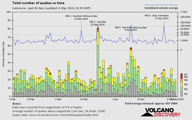
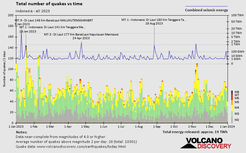
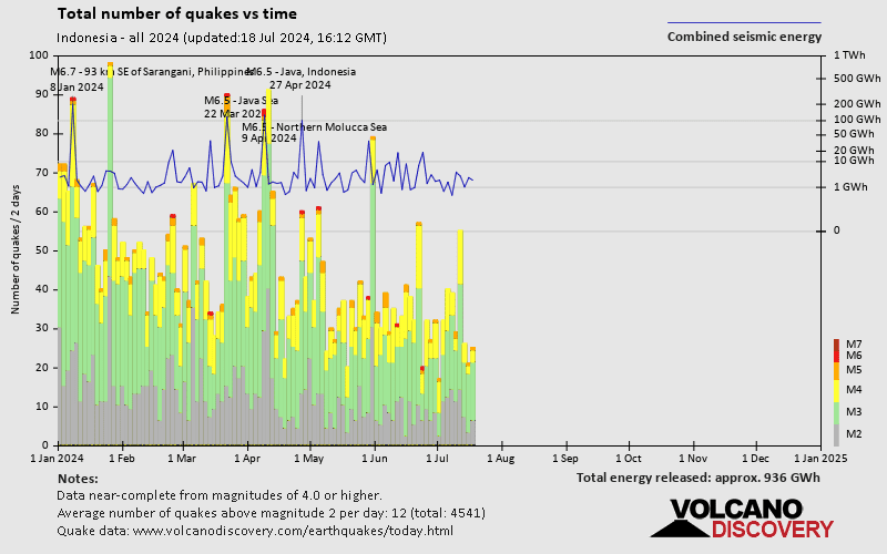
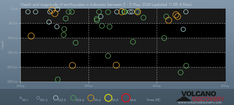
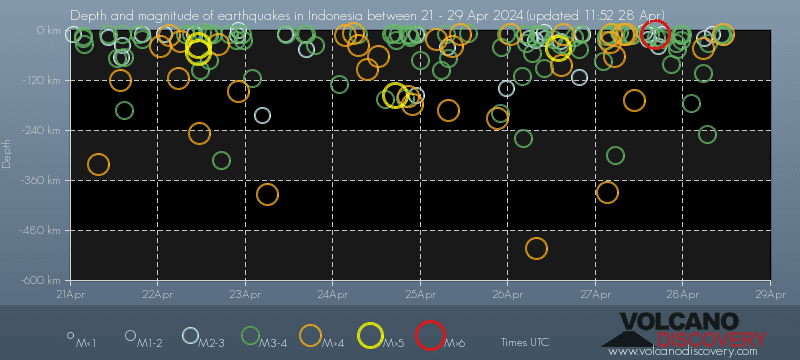
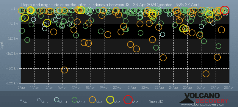
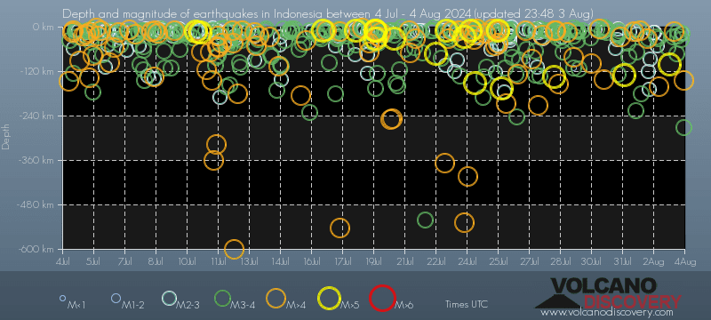
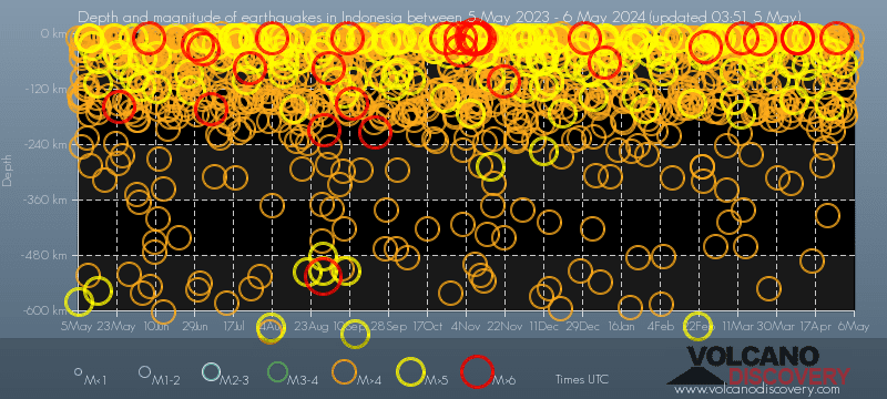
Indonesia has a very high level of seismic activity. Based on data from the past 14 years and our earthquake archive back to 1900, there are about 8,800 quakes on average per year in Indonesia. Indonesia has had at least 12 quakes above magnitude 8 since 1900, which suggests that larger earthquakes of this size occur infrequently, probably on average approximately every 10 to 15 years.
On average, Indonesia has about 6,500 quakes of magnitude 3 or higher per year (Mag 4+: 2,400 quakes per year, Mag 5+: 214 quakes per year, Mag 6+: 12.2 quakes per year).
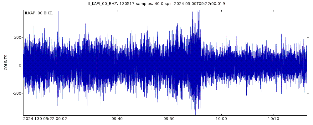
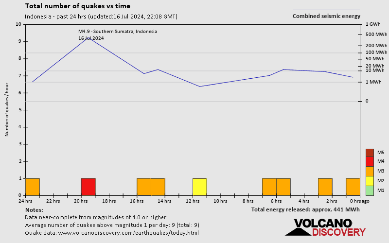
The last earthquake in Indonesia occurred 2 hours and 24 minutes ago and had a magnitude of 3.7:
A moderate magnitude 3.7 earthquake occurred in the Ceram Sea near the coast of Maluku, ![]() Indonesia, in the evening of Tuesday, Apr 23, 2024 at 8.09 pm local time (Asia/Jayapura GMT +9). The quake had a very shallow depth of 10 km (6 mi) and was not felt (or at least not reported so).
Indonesia, in the evening of Tuesday, Apr 23, 2024 at 8.09 pm local time (Asia/Jayapura GMT +9). The quake had a very shallow depth of 10 km (6 mi) and was not felt (or at least not reported so).
In the past 14 days, Indonesia has been shaken by 6 quakes of magnitude 5.0 or above, 59 quakes between 4.0 and 5.0, 180 quakes between 3.0 and 4.0, and 104 quakes between 2.0 and 3.0. There have been also 7 quakes below magnitude 2.0 which people don't normally feel.
The strongest earthquake in Indonesia in the past 14 days had a magnitude of 5.3 and occurred 1 day 2 hours ago:
A strong magnitude 5.3 earthquake occurred in the Indian Ocean near the coast of East Java, ![]() Indonesia, in the late afternoon of Monday, Apr 22, 2024 at 6.11 pm local time (GMT +7). The quake had a shallow depth of 35 km (22 mi) and was felt by many near the epicenter.
Indonesia, in the late afternoon of Monday, Apr 22, 2024 at 6.11 pm local time (GMT +7). The quake had a shallow depth of 35 km (22 mi) and was felt by many near the epicenter.
Date and Time | Mag Depth | ###DIST_LABEL### | Location | Details | Map |
|---|