Contact | RSS | EN | DE | EL | ES | FR | IT | RU

Past earthquakes in or near Japan: 2020 - list, stats and map

Updated: Apr 24, 2024 22:39 GMT -
In 2020, Japan has had 1,376 quakes of magnitudes above 2 and up to 6.6:
  • 7 quakes above magnitude 6
  • 92 quakes between magnitude 5 and 6
  • 713 quakes between magnitude 4 and 5
  • 373 quakes between magnitude 3 and 4
  • 191 quakes between magnitude 2 and 3
Strongest: Mag. 6.6 Earthquake Ryukyu Islands, Japan -
[smaller] [bigger]
Filter by magnitude:
all
5.0+
6.0+
Showing quakes magnitude 4.7 or higher, within up to 300 km (186 mi) distance (284 out of 1,376 quakes, show more):
Past earthquakes in or near Japan: 2020 - list, stats and map
Date and TimeMag
Depth
Nearest VolcanoLocationDetailsMap
Dec 30, 2020 09:35 am (GMT +9)
5.1

74 km
Near East Coast of Honshu, Japan 13 reportsInfo
Monday, December 28, 2020 GMT (1 quake)
Dec 29, 2020 04:23 am (GMT +9)
4.9

437 km
38 km (24 mi) to the SW Near S. Coast of Western Honshu, Japan
Info
Sunday, December 27, 2020 GMT (1 quake)
Dec 27, 2020 10:16 am (GMT +9)
4.7

534 km
98 km (61 mi) to the S - Bonin Islands, Japan region
Info
Thursday, December 24, 2020 GMT (1 quake)
Dec 25, 2020 05:38 am (GMT +9)
5.1

106 km
25 km (16 mi) to the SW - 44 km NNW of Miyanoura, Japan Info
Tuesday, December 22, 2020 GMT (3 quakes)
Dec 23, 2020 05:40 am (GMT +9)
5.0

475 km
245 km (152 mi) to the NW SEA OF JAPAN Info
Dec 23, 2020 03:24 am (GMT +9)
4.8

18 km
86 km (53 mi) to the SW Northwest of Ryukyu Islands, Japan
Info
Dec 23, 2020 02:04 am (GMT +9)
4.8

29 km
25 km (16 mi) to the NE 37 km SE of Namie, Japan
Info
Sunday, December 20, 2020 GMT (3 quakes)
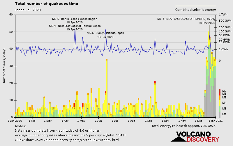
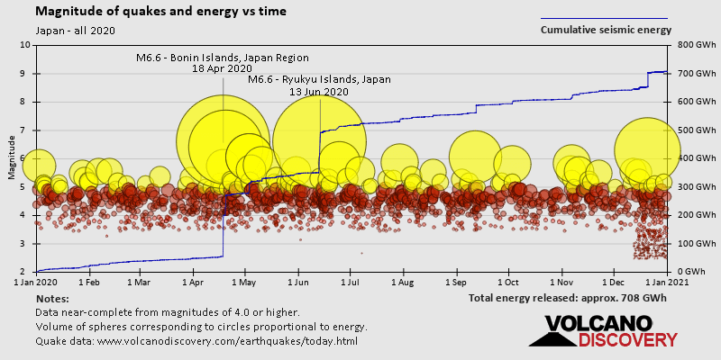
Dec 21, 2020 02:23 am (GMT +9)
6.3

35 km
88 km (55 mi) to the N North Pacific Ocean, 98 km northeast of Hachinohe, Aomori, Japan 10 reportsInfo
Dec 20, 2020 06:35 pm (GMT +9)
5.0

41 km
49 km (30 mi) to the NE - 76 km ESE of Ōfunato, Japan 2 reportsInfo
Dec 20, 2020 10:54 am (GMT +9)
4.7

10 km
216 km (134 mi) to the SE Off East Coast of Honshu, Japan
Info
Saturday, December 19, 2020 GMT (2 quakes)
Dec 19, 2020 04:04 pm (GMT +9)
4.8

20 km
60 km (37 mi) to the SW Philippine Sea, 90 km southeast of Naze, Kagoshima, Japan
Info
Show more
About these data
Estimated combined seismic energy released: 2.5 x 10¹⁵ joules (708 gigawatt hours, equivalent to 6.1 x 10⁵ tons of TNT or 38.1 atomic bombs!) | about seismic energy

Earthquake Catalog - Look up past earthquakes

Look up past earthquakes in this area by date or date range:
or
Look up quakes!
Felt a quake? Report it!
Show quakes near me!

Earthquake statistics

Number of earthquakes over time

in 2020
Number of earthquakes over time: in 2020

Magnitude and seismic energy over time

in 2020
Magnitude and seismic energy over time: in 2020

Magnitude and energy distribution

in 2020
Magnitude and energy distribution: in 2020

Embed or share standalone map

You can use the standalone version of our interactive earthquake map or embed it on your website:

Earthquakes in or near Japan

On this page:

Try our free app!
Volcanoes & Earthquakes - new app for Android
Android | iOS version
Why is there advertising on this site?

Support us - Help us upgrade our services!

We truly love working to bring you the latest volcano and earthquake data from around the world. Maintaining our website and our free apps does require, however, considerable time and resources.
We need financing to increase hard- and software capacity as well as support our editor team. We're aiming to achieve uninterrupted service wherever an earthquake or volcano eruption unfolds, and your donations can make it happen! Every donation will be highly appreciated. If you find the information useful and would like to support our team in integrating further features, write great content, and in upgrading our soft- and hardware, please make a donation (PayPal or Online credit card payment).

Planned features:Thanks to your past donations, these features have been added recently:
Download and Upgrade the Volcanoes & Earthquakes app to get one of the fastest seismic and volcano alerts online:
Android | IOS
Thank you!
Sources: VolcanoDiscovery / VolcanoAdventures and other sources as noted.
Use of material: Most text and images on our websites are owned by us. Re-use is generally not permitted without authorization. Contact us for licensing rights.
Volcanoes & Earthquakes
VolcanoDiscovery Home
Volcanoes | Earthquakes | Photos | Volcano News | App
Adventure & Study Travel
Tours to Volcanoes and Volcanic Areas: walking tours, photo tours, study tours
Tours & Dates | FAQ | About us
Get our newsletter!
Company info
Contact | Legal info | Terms & conditions
Follow us
Follow us on facebook Follow us on Instagram Follow us on Twitter Visit our Youtube channel
EN | DE | EL | ES | FR | IT | RU
VolcanoDiscovery GmbH, Germany, Reg. nr.: HRB 103744, EU Tax Id: DE 297 465 123 owned and created by
Dr. Tom Pfeiffer, volcanologist, volcano photographer, tour organizer member of
IAVCEI
IAVCEI
Vulkanologische Gesellschaft
Volcanological Society
Ecotourism Greece
Ecotourism Greece
RUV insurance
Insured by R+V
VolcanoDiscovery © 2004- All Rights Reserved | Privacy - Cookie Settings