SEARCH
| Latest See all | Mag. 3.2 earthquake Philippine Sea - 10.9 km northeast of Dolores, Philippines - |
| Latest felt | Mag. 4.0 earthquake Philippine Sea - 73 km northeast of Oras, Philippines - |
| Strongest past 14 days | Mag. 5.3 South China Sea - Cagayan Valley, Philippines - |
Date and Time | Mag Depth | Nearest Volcano | Location | Details | Map |
|---|---|---|---|---|---|
| Apr 24, 12:18 am (Manila) | 3.2 13 km | 6 km (3.7 mi) to the E | Info | ||
| Apr 23, 10:29 pm (GMT +8) | 4.0 7 km | 63 km (39 mi) to the E | Info | ||
| Apr 23, 10:23 pm (GMT +8) | 3.9 4 km | 60 km (37 mi) to the E | Info | ||
| Apr 23, 09:12 pm (GMT +8) | 3.0 25 km | 37 km (23 mi) to the N | Info | ||
| Apr 23, 08:58 pm (GMT +8) | 4.3 10 km | 66 km (41 mi) to the N | Info | ||
| Apr 23, 08:55 pm (GMT +8) | 5.3 20 km | 55 km (34 mi) to the N | Info | ||
| Apr 23, 04:56 pm (Manila) | 3.1 25 km | 2 km (1.2 mi) to the N | Info | ||
| Apr 23, 04:38 pm (GMT +8) | 3.3 13 km | 72 km (45 mi) to the SE | Info | ||
| Apr 23, 03:34 pm (Manila) | 4.2 10 km | Info | |||
| Apr 23, 01:39 pm (Manila) | 3.5 17 km | 8 km (5 mi) to the N | Info | ||
| Apr 23, 12:18 pm (Manila) | 3.2 13 km | 6 km (3.7 mi) to the E | Info |

| or | ||
Look up quakes! | ||
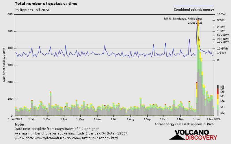

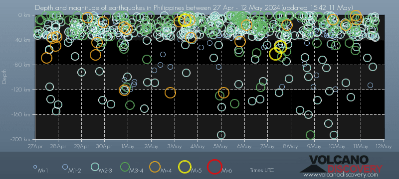
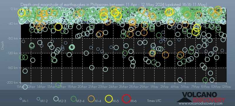
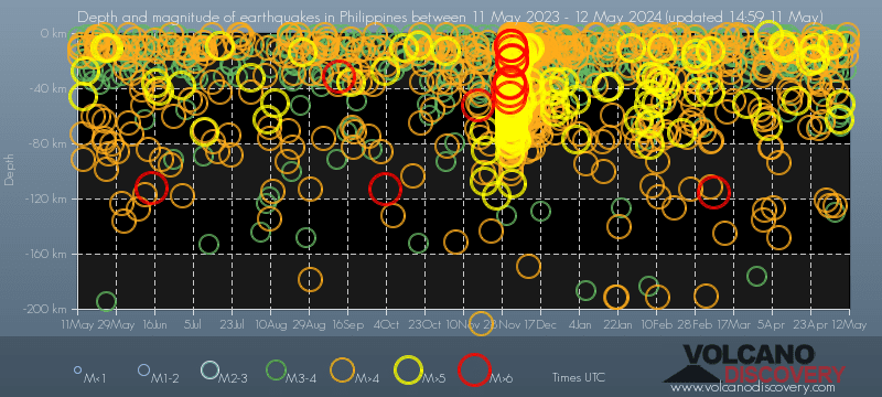
The Philippines have a very high level of seismic activity. Based on data from the past 14 years and our earthquake archive back to 1900, there are about 12,000 quakes on average per year in the Philippines. The Philippines have had at least 3 quakes above magnitude 8 since 1900, which suggests that larger earthquakes of this size occur infrequently, probably on average approximately every 40 to 45 years.
On average, The Philippines have about 2,700 quakes of magnitude 3 or higher per year (Mag 4+: 588 quakes per year, Mag 5+: 76 quakes per year, Mag 6+: 4.7 quakes per year).
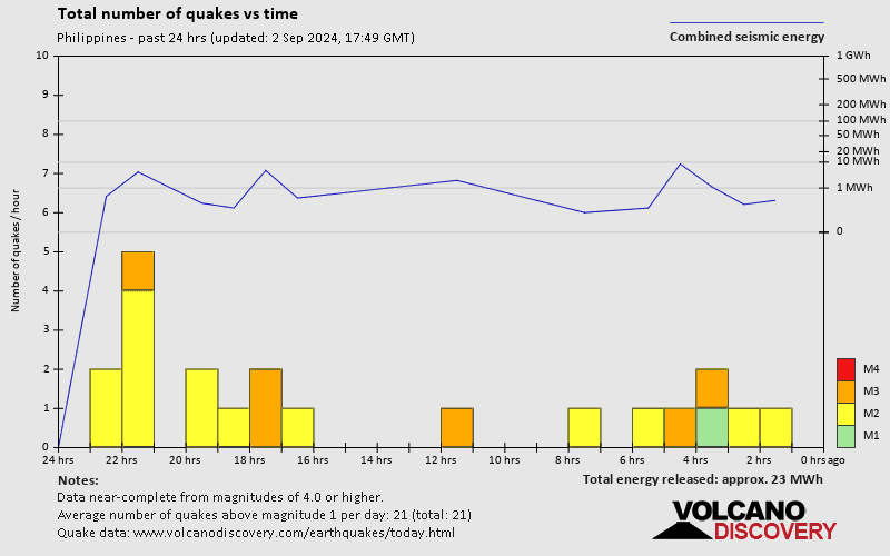
The last earthquake in the Philippines occurred 4 hours ago and had a magnitude of 3.2:
A light magnitude 3.2 earthquake occurred in the Philippine Sea near Samar island, Philippines, shortly after midnight, on Wednesday, Apr 24, 2024 at 12.18 am local time (Asia/Manila GMT +8). The quake had a very shallow depth of 13 km (8 mi) and was not felt (or at least not reported so).
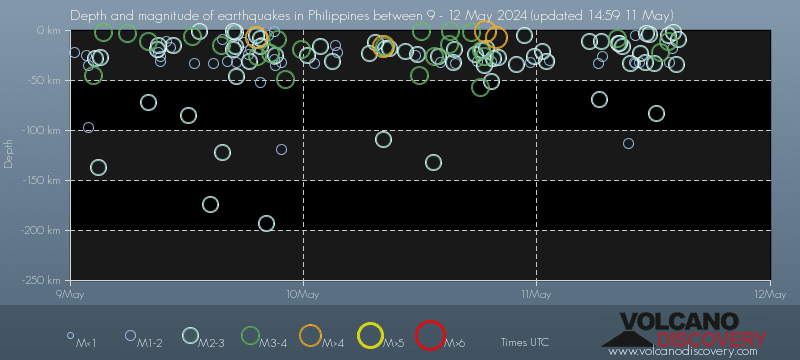
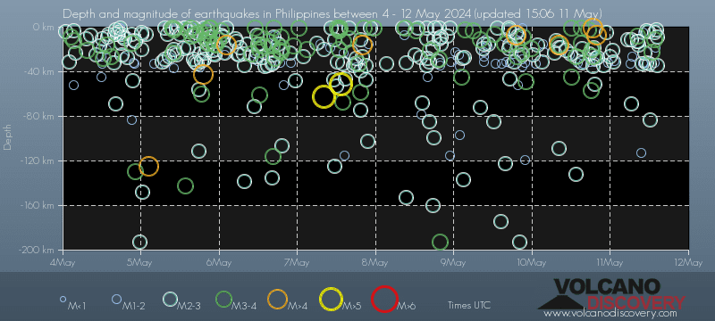
In the past 14 days, the Philippines has had 5 quakes of magnitude 5.0 or above, 20 quakes between 4.0 and 5.0, 111 quakes between 3.0 and 4.0, and 359 quakes between 2.0 and 3.0. There have been also 233 quakes below magnitude 2.0 which people don't normally feel.
The strongest earthquake in the Philippines in the past 14 days had a magnitude of 5.3 and occurred 7 hours ago:
A strong magnitude 5.3 earthquake occurred in the South China Sea near the coast of Cagayan Valley, ![]() Philippines, in the evening of Tuesday, Apr 23, 2024 at 8.55 pm local time (GMT +8). The quake had a very shallow depth of 19.6 km (12 mi) and was reported felt by some people near the epicenter.
Philippines, in the evening of Tuesday, Apr 23, 2024 at 8.55 pm local time (GMT +8). The quake had a very shallow depth of 19.6 km (12 mi) and was reported felt by some people near the epicenter.
Date and Time | Mag Depth | ###DIST_LABEL### | Location | Details | Map |
|---|