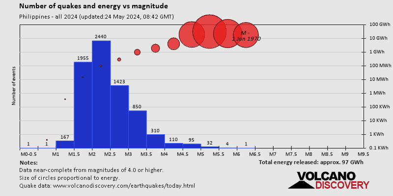
SEARCH
Date and Time | Mag Depth | Nearest Volcano | Location | Details | Map |
|---|---|---|---|---|---|
| Feb 1, 05:29 am (GMT +8) | 3.7 2 km | 90 km (56 mi) to the SE | Info | ||
| Feb 1, 04:46 am (Manila) | 4.8 78 km | 5 km (3.1 mi) to the W | Info | ||
| Feb 1, 02:31 am (Makassar) | 3.8 30 km | 223 km (139 mi) to the SE | Info | ||
| Feb 1, 02:00 am (Manila) | 3.7 23 km | Info | |||
| Feb 1, 12:13 am (GMT +8) | 4.0 15 km | 141 km (88 mi) to the SE | Info | ||
| Tuesday, January 30, 2024 GMT (5 quakes) | |||||
| Jan 31, 05:23 am (GMT +8) | 3.9 11 km | 40 km (25 mi) to the NW | Info | ||
| Jan 31, 12:12 am (GMT +8) | 3.8 21 km | 70 km (43 mi) to the SE | Info | ||
| Jan 30, 11:55 pm (GMT +8) | 3.4 12 km | 25 km (16 mi) to the SE | Info | ||
| Jan 30, 04:42 pm (GMT +8) | 3.5 1 km | 85 km (53 mi) to the SE | Info | ||
| Jan 30, 02:47 pm (GMT +8) | 4.6 69 km | 48 km (30 mi) to the SE | Info | ||
| Monday, January 29, 2024 GMT (5 quakes) | |||||
| Jan 30, 12:06 am (GMT +8) | 3.5 137 km | 196 km (122 mi) to the SE | Info | ||
| or | ||
Look up quakes! | ||