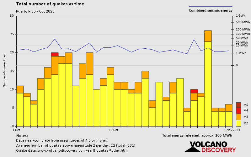
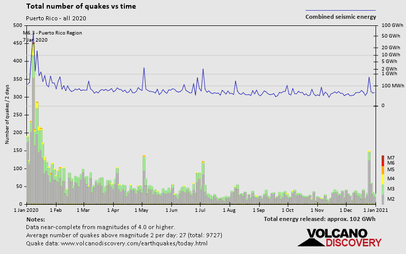
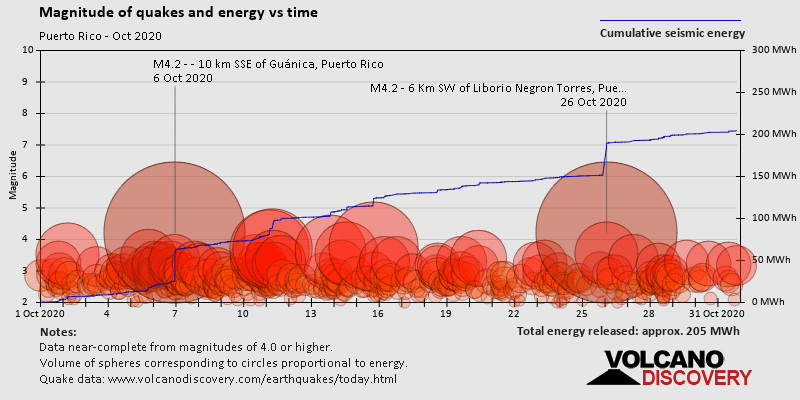
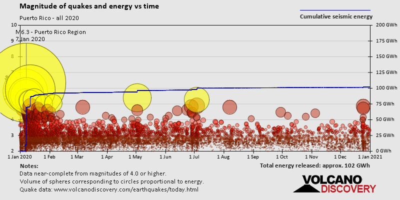
Contact | RSS | EN | DE | EL | ES | FR | IT | RU

Past earthquakes in or near Puerto Rico: October 2020 - list, stats and map

Updated: Apr 16, 2024 16:16 GMT -
During October 2020, Puerto Rico has had 388 quakes of magnitudes up to 5.3:
  • 0 quakes above magnitude 5
  • 2 quakes between magnitude 4 and 5
  • 61 quakes between magnitude 3 and 4
  • 318 quakes between magnitude 2 and 3
  • 7 quakes below magnitude 2 that people normally don't feel.
Strongest: Mag. 5.3 Earthquake 61 Km ENE of Saint Croix, U.S. Virgin Islands -
[smaller] [bigger]
Filter by magnitude:
all
2.0+
3.0+
4.0+
5.0+
Showing quakes magnitude 2.7 or higher, within up to 300 km (186 mi) distance (289 out of 388 quakes, show more):
Past earthquakes in or near Puerto Rico: October 2020 - list, stats and map
Date and TimeMag
Depth
Nearest VolcanoLocationDetailsMap
Oct 31, 2020 04:30 pm (Santo Domingo)
3.2

18 km
205 km (127 mi) to the W 20 km NW of Sabana de La Mar, Dominican Republic
Info
Oct 31, 2020 04:22 pm (Puerto Rico)
3.1

3 km
19 km (12 mi) to the SE 24 km SW of Esperanza, Puerto Rico
Info
Oct 31, 2020 09:51 am (Santo Domingo)
3.5

116 km
284 km (176 mi) to the W 57 km southeast of Santiago de los Caballeros, Dominican Republic
Info
Oct 31, 2020 07:34 am (GMT -4)
3.2

30 km
51 km (32 mi) to the NW 78 km NNW of Mayagüez, Puerto Rico
Info
Oct 31, 2020 04:50 am (Puerto Rico)
2.7

13 km
2 km (1.2 mi) to the SW 14 km SSW of Yauco, Puerto Rico
Info
Friday, October 30, 2020 GMT (4 quakes)
Oct 30, 2020 10:01 am (GMT -4)
3.2

22 km
55 km (34 mi) to the S 83 km SE of Ponce, Puerto Rico
Info
Oct 30, 2020 06:15 am (Santo Domingo)
2.8

153 km
105 km (65 mi) to the W 32 km S of La Romana, Dominican Republic
Info
Oct 30, 2020 03:54 am (Puerto Rico)
2.8

15 km
19 km W of Ponce, Puerto Rico 1 report
Info
Oct 30, 2020 02:41 am (Puerto Rico)
2.7

67 km
21 km SW of San Juan, Puerto Rico
Info
Thursday, October 29, 2020 GMT (5 quakes)
Oct 29, 2020 07:51 pm (Puerto Rico)
2.7

13 km
24 km W of Ponce, Puerto Rico
Info
Oct 29, 2020 02:35 pm (Santo Domingo)
2.7

98 km
182 km (113 mi) to the W 2.4 km WNW of Boca Chica, Dominican Republic
Info
Show more
About these data
Estimated combined seismic energy released: 8.7 x 10¹² joules (2.41 gigawatt hours, equivalent to 2072 tons of TNT or 0.1 atomic bombs!) | about seismic energy

Earthquake Catalog - Look up past earthquakes

Look up past earthquakes in this area by date or date range:
or
Look up quakes!
Felt a quake? Report it!
Show quakes near me!

Earthquake statistics

Number of earthquakes over time

during October 2020
in 2020
Number of earthquakes over time: during October 2020
Number of earthquakes over time: in 2020

Magnitude and seismic energy over time

during October 2020
in 2020
Magnitude and seismic energy over time: during October 2020
Magnitude and seismic energy over time: in 2020

Magnitude and energy distribution

during October 2020
in 2020
Magnitude and energy distribution: during October 2020
Magnitude and energy distribution: in 2020

Embed or share standalone map

You can use the standalone version of our interactive earthquake map or embed it on your website:

Quakes in nearby regions

On this page:

Try our free app!
Volcanoes & Earthquakes - new app for Android
Android | iOS version
Why is there advertising on this site?

Support us - Help us upgrade our services!

We truly love working to bring you the latest volcano and earthquake data from around the world. Maintaining our website and our free apps does require, however, considerable time and resources.
We need financing to increase hard- and software capacity as well as support our editor team. We're aiming to achieve uninterrupted service wherever an earthquake or volcano eruption unfolds, and your donations can make it happen! Every donation will be highly appreciated. If you find the information useful and would like to support our team in integrating further features, write great content, and in upgrading our soft- and hardware, please make a donation (PayPal or Online credit card payment).

Planned features:Thanks to your past donations, these features have been added recently:
Download and Upgrade the Volcanoes & Earthquakes app to get one of the fastest seismic and volcano alerts online:
Android | IOS
Thank you!
Sources: VolcanoDiscovery / VolcanoAdventures and other sources as noted.
Use of material: Most text and images on our websites are owned by us. Re-use is generally not permitted without authorization. Contact us for licensing rights.
Volcanoes & Earthquakes
VolcanoDiscovery Home
Volcanoes | Earthquakes | Photos | Volcano News | App
Adventure & Study Travel
Tours to Volcanoes and Volcanic Areas: walking tours, photo tours, study tours
Tours & Dates | FAQ | About us
Get our newsletter!
Company info
Contact | Legal info | Terms & conditions
Follow us
Follow us on facebook Follow us on Instagram Follow us on Twitter Visit our Youtube channel
EN | DE | EL | ES | FR | IT | RU
VolcanoDiscovery GmbH, Germany, Reg. nr.: HRB 103744, EU Tax Id: DE 297 465 123 owned and created by
Dr. Tom Pfeiffer, volcanologist, volcano photographer, tour organizer member of
IAVCEI
IAVCEI
Vulkanologische Gesellschaft
Volcanological Society
Ecotourism Greece
Ecotourism Greece
RUV insurance
Insured by R+V
VolcanoDiscovery © 2004- All Rights Reserved | Privacy - Cookie Settings