SEARCH
Date and Time | Mag Depth | Nearest Volcano | Location | Details | Map |
|---|---|---|---|---|---|
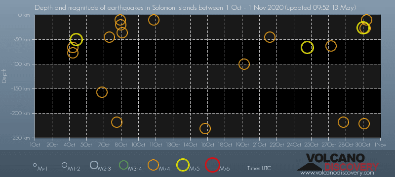
| Oct 31, 2020 05:37 am (Guadalcanal) | 4.6 10 km | 3 km (1.9 mi) to the E | Info | ||
| Oct 31, 2020 01:47 am (GMT +11) | 4.6 27 km | 41 km (25 mi) to the SE | Info | ||
| Oct 31, 2020 12:01 am (GMT +11) | 4.7 221 km | 60 km (37 mi) to the SE | Info | ||
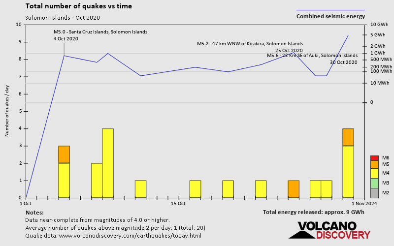
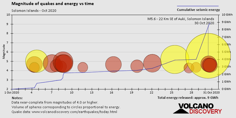
| Oct 30, 2020 10:10 pm (Guadalcanal) | 5.6 26 km | Info | |||
| Wednesday, October 28, 2020 GMT (2 quakes) | |||||
| Oct 29, 2020 02:49 am (Guadalcanal) | 4.3 218 km | 9 km (5.6 mi) to the SE | Info | ||
| Oct 28, 2020 04:41 pm (GMT +10) | 4.7 10 km | 188 km (117 mi) to the W | Info | ||
| Tuesday, October 27, 2020 GMT (2 quakes) | |||||
| Oct 28, 2020 12:50 am (GMT +11) | 4.3 63 km | 57 km (35 mi) to the SE | Info | ||
| Oct 28, 2020 12:34 am (GMT +11) | 4.1 229 km | 111 km (69 mi) to the SE | Info | ||
| Monday, October 26, 2020 GMT (1 quake) | |||||
| Oct 26, 2020 12:58 pm (GMT +10) | 4.9 10 km | 171 km (106 mi) to the W | Info | ||
| Sunday, October 25, 2020 GMT (1 quake) | |||||
| Oct 25, 2020 10:04 pm (Guadalcanal) | 5.2 66 km | 3 km (1.9 mi) to the SE | Info | ||
| Thursday, October 22, 2020 GMT (1 quake) | |||||
| Oct 22, 2020 12:57 pm (Guadalcanal) | 4.8 45 km | 48 km (30 mi) to the SE | Info | ||
| or | ||
Look up quakes! | ||