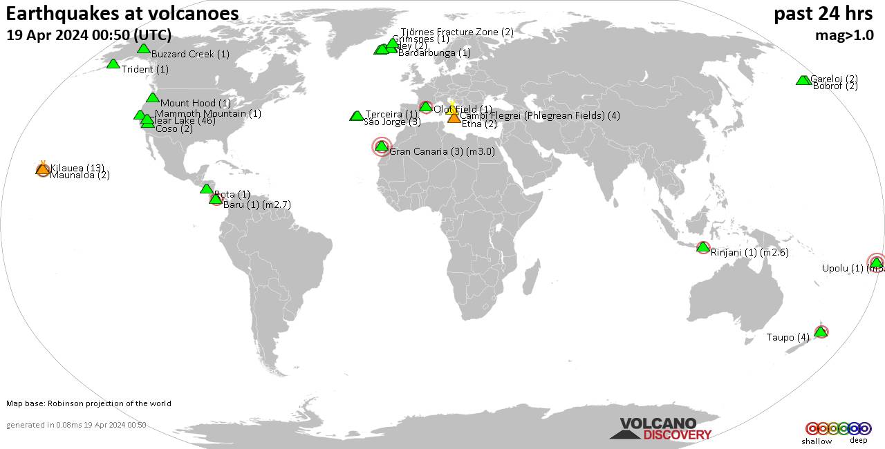
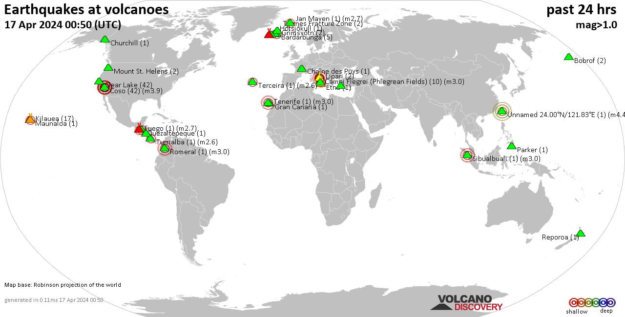
Contact | RSS | EN | DE | EL | ES | FR | IT | RU

Earthquakes and Volcanoes

Past earthquakes near active volcanoes: May 10, 2021 - list, stats and map

Updated: Apr 19, 2024 20:51 GMT -

Volcanoes with recent nearby earthquakes:

[smaller] [bigger]
Filter by magnitude:
all
3.0+
4.0+
5.0+
Showing quakes magnitude 0.5 or higher (228 quakes):
Past earthquakes near active volcanoes: May 10, 2021 - list, stats and map
Date and TimeMag
Depth
Nearest VolcanoLocationDetailsMap
May 10, 2021 11:38 pm (Reykjavik)
0.4

9.8 km
27 km (17 mi) S of5.3 Km ESE of Þorlákshöfn, Iceland
Info
May 10, 2021 04:30 pm (Los Angeles)
1.0

2.4 km
18 km (11 mi) S of7km WNW of The Geysers, CA, USA
Info
May 11, 2021 02:20 am (Mayotte)
1.8

36 km
22 km (14 mi) E ofNear Mamoudzou, Mayotte
Info
May 10, 2021 04:20 pm (Los Angeles)
2.1

2.2 km
18 km (11 mi) S of7km NW of The Geysers, CA, USA
Info
May 10, 2021 04:09 pm (Los Angeles)
0.6

2.8 km
15 km (9.3 mi) S of4km WNW of Cobb, CA, USA
Info
May 10, 2021 11:05 pm (Reykjavik)
0.5

5 km
9 km (5.6 mi) E of19.5 Km W of Kópasker, Iceland
Info
May 11, 2021 12:46 am (Berlin)
0.3

9.6 km
9 km (5.6 mi) SE ofOchtendung (RP), Germany
Info
May 11, 2021 05:33 am (Jakarta)
2.3

10 km
23 km (14 mi) N ofNorthern Sumatra, Indonesia
Info
May 11, 2021 05:32 am (Jakarta)
2.1

10 km
20 km (12 mi) N ofNorthern Sumatra, Indonesia
Info
May 11, 2021 12:27 am (Rome)
1.0

5.1 km
15 km (9.3 mi) W of5 Km S Bronte (CT), Italy
Info
May 11, 2021 05:27 am (Jakarta)
2.2

10 km
21 km (13 mi) E ofNorthern Sumatra, Indonesia
Info
Show more
About these data
Estimated combined seismic energy released: 3.9 x 10¹² joules (1.08 gigawatt hours, equivalent to 933 tons of TNT) | about seismic energy

Earthquake Catalog - Look up past earthquakes

Look up past earthquakes in this area by date or date range:
or
Look up quakes!
Felt a quake? Report it!
Show quakes near me!

Embed or share standalone map

You can use the standalone version of our interactive earthquake map or embed it on your website:

On this page:

Fri, 19 Apr 2024, 20:50

Volcano earthquake report for Friday, 19 Apr 2024

World map showing volcanoes with shallow (less than 50 km) earthquakes within 20 km radius  during the past 24 hours on 19 Apr 2024 Number in brackets indicate nr of quakes.
Quakes detected near: Arenal (1 quake mag 3.0), Bardarbunga (2 quakes between mag 1.2-1.6), Bobrof (7 quakes between mag 1.3-2.6), Brennisteinsfjöll (2 quakes between mag 0.6-1.1), Buzzard Creek (1 quake mag 1.5), Campi Flegrei (Phlegrean Fields) (2 quakes between mag 1.2-1.6) ... Read all
Thu, 18 Apr 2024, 23:50

Volcano earthquake report for Thursday, 18 Apr 2024

World map showing volcanoes with shallow (less than 50 km) earthquakes within 20 km radius  during the past 24 hours on 18 Apr 2024 Number in brackets indicate nr of quakes.
Quakes detected near: Bardarbunga (3 quakes between mag 0.0-1.6), Baru (1 quake mag 2.7), Bobrof (1 quake mag 1.9), Brennisteinsfjöll (5 quakes between mag 0.1-1.0), Buzzard Creek (1 quake mag 1.5), Campi Flegrei (Phlegrean Fields) (4 quakes between mag 1.0-1.9) ... Read all
Wed, 17 Apr 2024, 23:50

Volcano earthquake report for Wednesday, 17 Apr 2024

World map showing volcanoes with shallow (less than 50 km) earthquakes within 20 km radius  during the past 24 hours on 17 Apr 2024 Number in brackets indicate nr of quakes.
Quakes detected near: Bardarbunga (4 quakes between mag 0.2-1.2), Barva (1 quake mag 3.0), Brennisteinsfjöll (4 quakes between mag 0.3-1.0), Campi Flegrei (Phlegrean Fields) (1 quake mag 1.3), Chaîne des Puys (1 quake mag 1.0), Churchill (2 quakes between mag 1.0-1.0) ... Read all
Try our free app!
Volcanoes & Earthquakes - new app for Android
Android | iOS version
Why is there advertising on this site?

Support us - Help us upgrade our services!

We truly love working to bring you the latest volcano and earthquake data from around the world. Maintaining our website and our free apps does require, however, considerable time and resources.
We need financing to increase hard- and software capacity as well as support our editor team. We're aiming to achieve uninterrupted service wherever an earthquake or volcano eruption unfolds, and your donations can make it happen! Every donation will be highly appreciated. If you find the information useful and would like to support our team in integrating further features, write great content, and in upgrading our soft- and hardware, please make a donation (PayPal or Online credit card payment).

Planned features:Thanks to your past donations, these features have been added recently:
Download and Upgrade the Volcanoes & Earthquakes app to get one of the fastest seismic and volcano alerts online:
Android | IOS
Thank you!
Sources: VolcanoDiscovery / VolcanoAdventures and other sources as noted.
Use of material: Most text and images on our websites are owned by us. Re-use is generally not permitted without authorization. Contact us for licensing rights.
Volcanoes & Earthquakes
VolcanoDiscovery Home
Volcanoes | Earthquakes | Photos | Volcano News | App
Adventure & Study Travel
Tours to Volcanoes and Volcanic Areas: walking tours, photo tours, study tours
Tours & Dates | FAQ | About us
Get our newsletter!
Company info
Contact | Legal info | Terms & conditions
Follow us
Follow us on facebook Follow us on Instagram Follow us on Twitter Visit our Youtube channel
EN | DE | EL | ES | FR | IT | RU
VolcanoDiscovery GmbH, Germany, Reg. nr.: HRB 103744, EU Tax Id: DE 297 465 123 owned and created by
Dr. Tom Pfeiffer, volcanologist, volcano photographer, tour organizer member of
IAVCEI
IAVCEI
Vulkanologische Gesellschaft
Volcanological Society
Ecotourism Greece
Ecotourism Greece
RUV insurance
Insured by R+V
VolcanoDiscovery © 2004- All Rights Reserved | Privacy - Cookie Settings