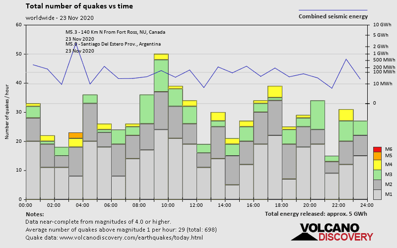
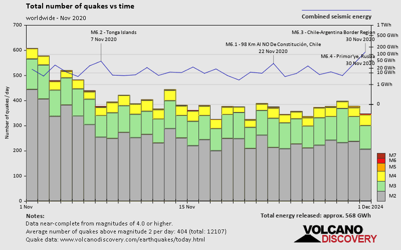
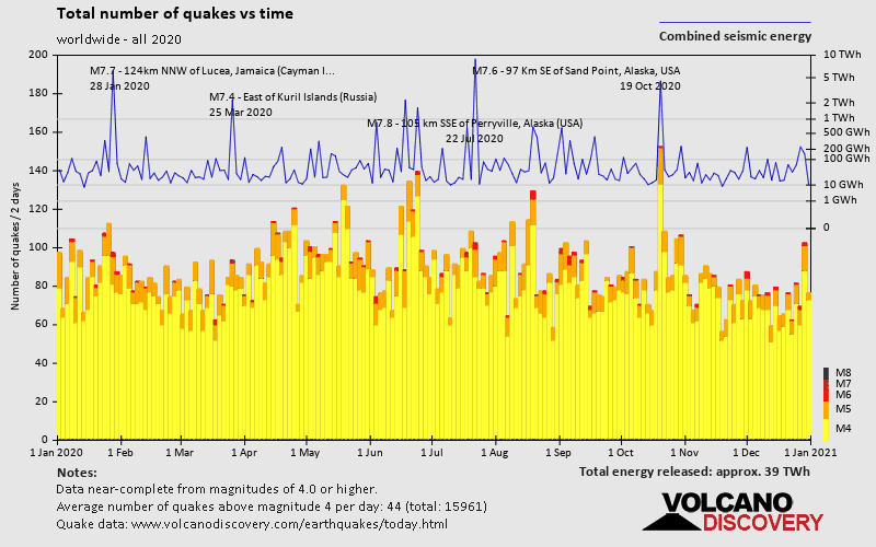
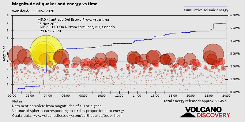
Past earthquakes worldwide: Nov 23, 2020 - list, stats and map
| Nov 23, 2020 07:41 pm (Santiago) | 3.1
31 km | |  48 km northwest of Ovalle, Limarí, Coquimbo, Chile 48 km northwest of Ovalle, Limarí, Coquimbo, Chile | Info | |
| Nov 23, 2020 07:35 pm (Toronto) | 3.2
18 km | |  Manicouagan Regional County Municipality, 14 km northeast of Baie-Trinité (Côte-Nord), Quebec, Canada 1 report Manicouagan Regional County Municipality, 14 km northeast of Baie-Trinité (Côte-Nord), Quebec, Canada 1 report | Info | |
| Nov 23, 2020 05:34 pm (Costa Rica) | 3.0
9 km | |  North Pacific Ocean, 26 km southeast of Puntarenas, Provincia de Puntarenas, Costa Rica North Pacific Ocean, 26 km southeast of Puntarenas, Provincia de Puntarenas, Costa Rica | Info | |
| Nov 23, 2020 05:27 pm (Guatemala) | 3.9
2 km | |  Municipio de San Pedro Carcha, Alta Verapaz Department, 8.4 km northeast of San Pedro Carchá (Alta Verapaz), Guatemala Municipio de San Pedro Carcha, Alta Verapaz Department, 8.4 km northeast of San Pedro Carchá (Alta Verapaz), Guatemala | Info | |
| Nov 23, 2020 05:13 pm (Guatemala) | 3.9
1 km | | Municipio de San Pedro Carcha, Alta Verapaz Department, 51 km northeast of Cobán (Alta Verapaz), Guatemala | Info | |
| Nov 24, 2020 06:55 am (Makassar) | 3.8
34 km | |  Philippine Sea, 340 km north of Tobelo, Kabupaten Halmahera Utara, Maluku Utara, Indonesia Philippine Sea, 340 km north of Tobelo, Kabupaten Halmahera Utara, Maluku Utara, Indonesia | Info | |
| Nov 23, 2020 01:53 pm (GMT -9) | 3.6
36 km | |  County, 90 mi east of Sand Point (Aleutians East County), Alaska, USA County, 90 mi east of Sand Point (Aleutians East County), Alaska, USA | Info | |
| Nov 23, 2020 04:50 pm (Mexico City) | 3.3
12 km | |  North Pacific Ocean, 17 km southwest of Escobilla, Santa María Tonameca, Oaxaca, Mexico North Pacific Ocean, 17 km southwest of Escobilla, Santa María Tonameca, Oaxaca, Mexico | Info | |
| Nov 23, 2020 03:42 pm (Tijuana) | 3.3
9 km | | Juárez, 9.8 km west of Arroyo Grande (Mexicali Municipality), Baja California, Mexico | Info | |
| Nov 23, 2020 06:36 pm (Santo Domingo) | 3.6
13 km | |  Municipio de Enriquillo, 42 km southwest of Santa Cruz de Barahona, Barahona, Dominican Republic Municipio de Enriquillo, 42 km southwest of Santa Cruz de Barahona, Barahona, Dominican Republic | Info | |
| Nov 24, 2020 10:30 am (GMT +12) | 4.9
100 km | |  South Pacific Ocean, 513 km northeast of Ruatoria, Gisborne District, New Zealand 1 report South Pacific Ocean, 513 km northeast of Ruatoria, Gisborne District, New Zealand 1 report | Info | |