(stratovolcanoes 2036 m / 6,680 ft)
Apaneca Range (Cuyanausul Range) is a group of E-W trending stratovolcanoes and geothermal areas located in western El Salvador, between the Santa Ana complex and the Guatemala border, about 6 km SE of Ahuachapin town. The volcanoes are basaltic-to-andesitic and Pleistocene and H... [
more info]
(volcanic field 700? m / 2,297 ft)
Apastepeque volcano is a young volcanic field 8 km north of San Vicente town in central El Salvador. The Volcanic features contains about 24 closely spaced cinder cones, lava flows, lava domes, and maars. The latter are now filled by lakes, such as Laguna de Apastepeque and Lagun... [
more info]
(volcanic field 665 m / 2,182 ft)
Cerro Cinotepeque volcano is a group of 4 young cinder cones on both sides of Río Lempa, about 40 km north of San Salvador city.
Cerro Cinotepeque (also spelled Cinotepec) lies south of the river, 2 other cones, Cerro Santiago and Cerro Mosquito, immediately north of the ri... [
more info]
(Stratovolcano(es) 782 m / 2566 ft)
[
more info]
(cinder cones 957 m / 3,140 ft)
Cerro Singüil (also known as El Cerron) is a large scoria cone SE of Volcán Chingo in the interior valley of El Salvador near the Guatemalan border. The volcano has a well-preserved summit crater and belongs to a young volcanic field of cinder cones and explosion craters. [
more info]
(Stratovolcano(es) 613 m / 2011 ft)
[
more info]
(stratovolcano 1300 m / 4,265 ft)
Chinameca volcano (also known as El Pacayal) is a small stratovolcano next to the larger San Miguel volcano in eastern El Salvador. It is connected to San Miguel across a low saddle to the SE.
Chinameca is truncated by a 2-km-wide, steep-sided caldera, Laguna Seca el Pacay... [
more info]
(caldera 746 m / 2,447 ft)
Coatepeque volcano is a large 7 x 10 km wide caldera 50 km west of San Salvador city. The caldera is elongated in SE-NW direction, with walls rising up to 800 m above the floor in its southwestern part. An up to 120 m deep and 5 km diameter lake occupies the eastern part of the c... [
more info]
(stratovolcano 1225 m / 4,019 ft)
Conchagua volcano (also known as Cochague) is an eroded stratovolcano on the western side of the Gulf of Fonseca in at the southeastern tip of El Salvador.
The main summit of Conchagua is Cerro del Ocote, but the secondary summit Cerro de La Bandera to the ENE of the elonga... [
more info]
(stratovolcano 505 m / 1,657 ft)
Conchagüita volcano at the SE tip of El Salvador forms a small 4-km-wide island in the Gulf of Fonseca separated from Conchagua volcano across a narrow strait.
The volcano is a sharp-topped cone with a 100-m-wide summit crater at the southern end and contains a young lava ... [
more info]
(stratovolcano 1438 m / 4,718 ft)
Guazapa volcano an eroded basaltic stratovolcano 23 km NE of San Salvador city. It is not known whether the Pleistocene volcano is still active. It shows signs of intense erosion that have cut deep valleys into its flanks, suggestin a very long dormany period, and there is no cra... [
more info]
(caldera 450 m / 1,476 ft)
Ilopango volcano is a 8x11 km wide caldera at the eastern margin of San Salvador city, El Salvador. It is elongated to the east, has 150-500 m high walls and contains the scenic Lake Ilopango, one of El Salvador's largest.
The caldera is the result of at least 4 large plini... [
more info]
(Stratovolcano(es) 468 m / 1535 ft)
[
more info]
(Pyroclastic cone(s) 158 m / 518 ft)
[
more info]
(stratovolcano 1950 m / 6,398 ft)
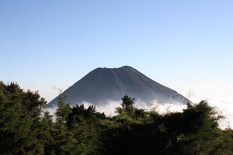
Izalco volcano, El Salvador (image courtesy: Angela Rucker, USAID)
Izalco volcano was born in 1770 and is the youngest volcano in El Slavador. It formed on the southern flank of Santa Ana volcano located 45 km NW of San Salvador city.
Frequent strombolian eruptions and sometimes lava flows have built a largely unvegetated cone 650 m high w... [
more info]
Laguna Aramuaca volcano is a lake-filled explosion crater (maar) 10 km SE of the city of San Miguel in southeastern El Salvador.
The crater is 1 km wide and might have formed less than 10,000 years. The phreatomagmatic eruptions that formed it left spectacular pyroclastic ... [
more info]
(Pyroclastic cone(s) 420 m / 1378 ft)
[
more info]
(volcanic field 781 m / 2,562 ft)
San Diego volcano is a young basaltic volcanic field near Lake Güija at the border between El Salvador and Guatemala. It contains cinder cones and unvegetated, fresh-looking lava flows.
The lava flows from San Diego volcanic field have created a natural dam to form Lake Güi... [
more info]
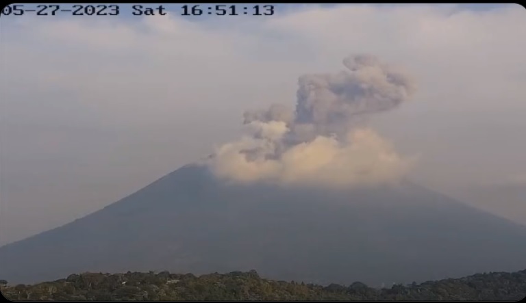
(stratovolcano 2130 m / 6,988 ft)
San Miguel volcano (also known locally as Chaparrastique) in eastern El Salvador is a symmetrical stratovolcano and one of the most active volcanoes of the country. It rises majestically from near sea level to 2130 m elevation and forms a prominent land mark.
The volcano's ... [
more info]
(stratovolcano 1893 m / 6,211 ft)
San Salvador volcano is a massive stratovolcano immediately northwestwest of El Salvador city. Its modern summit cone is also called the Boqueron stratovolcano. It formed within a 6 km wide caldera left by the collapse of the predecessor volcano about 40,000 years ago. Remnants o... [
more info]
(stratovolcano 2182 m / 7,159 ft)
San Vicente volcano (also known as Chichontepec) is a twin-peaked stratovolcano SE of Lake Ilopango. It is the second highest volcano in El Salvador and probably still active although there are no known historical eruptions. There are many hot springs and fumaroles on the norther... [
more info]
(stratovolcano 2381 m / 7,812 ft)
Santa Ana (also known as Ilamatepec) volcano is a stratovolcano about 45 km west of San Salvador city. It is El Salvador's highest volcano and one of its most active.
The broad summit of Santa Ana has a beautiful array of concentric craters with crescent-shaped rims.
more info]
(stratovolcano 1172 m / 3,845 ft)
Taburete volcano is a basaltic to basaltic-andesite stratovolcano rising above the Pacific coastal plain east of the Río Lempa in El Salvador, located at the SW end of a cluster of volcanoes between San Vincente and San Miguel volcanoes.
Volcan Taburete contains a well-pres... [
more info]
(stratovolcano 1593 m / 5,226 ft)
Tecapa volcano a complex basaltic-to-andesitic stratovolcano in east-central El Salvador. It is located at the NW end of a cluster of volcanoes east of the Río Lempa between San Vicente and San Miguel volcanoes. [
more info]
(stratovolcano 1449 m / 4,754 ft)
Usulután volcano is a stratovolcano in east-central El Salvador, at the SE end of a cluster of basaltic to basaltic-andesite stratovolcanoes between San Vicente and San Miguel volcanoes.
The volcano contains a broad 1.3-km-wide summit crater breached to the east. The flank... [
more info]