Erebus Volcano
Antarctica, -77.53°S / 167.17°E
Current status: erupting (4 out of 5)
Mount Erebus stratovolcano is the highest and most active volcano of Antarctica, one of the Volcanic Seven Summits, and the largest of 4 volcanoes that form the roughly triangular Ross Island (Mt Erebus, and the extinct Mt. Bird to the north, Mt. Terra Nova and Mt. Terror to the east).
Hut Point Peninsula to the south is the location of McMurdo Station (the main US base) and Scott Base (the main New Zealand base).
Mount Erebus volcano, located on the western half of Ross Island, Antarctica, is the world's southernmost historically active volcano and famous for its active boiling lava lake.
Its summit temperature averages between -20 (summer) and -50 deg C (winter) and it is covered by glaciers. It was discovered by explorer Caption James Ross in 1841 and climbed 1908 by members of Ernest Shackleton's expedition. Since then it was visited only very rarely in the following 100 years.
Erebus volcano eruptions: 1972 (Dec) -ongoing, 1972 (Jan), 1963, 1957 (?)-1958, 1955, 1947, 1915, 1912, 1911, 1908, 1903±2, 1900 (?), 1841, 950 AD ± 1000 years, 2050 BC ± 1000, 2950 BC ± 300, 4050 BC ± 500, 4550 BC ± 500, 7050 BC ± 1000, 8050 BC ± 1000
Latest nearby earthquakes
| Time | Mag. / Depth | Distance / Location | |||
Background
Geologic settingMt. Erebus volcano is an intraplate volcano and belongs to the McMurdo Volcanic Group, located in the so-called Terror Rift, which is part of the West Antarctic Rift System. This area is a rift zone where extension takes place and has thinned the crust to 20 km and allows magma to rise. The magma source beneath Erebus is sometimes described as a plume rising from the upper mantle at velocities of around 6 cm per year.
Morphology
The Erebus stratovolcano has undergone at least one or two caldera formations. It contains a summit plateau at about 3200-m, marking the rim of the youngest caldera, which formed during the late-Pleistocene and within which the modern cone was constructed.
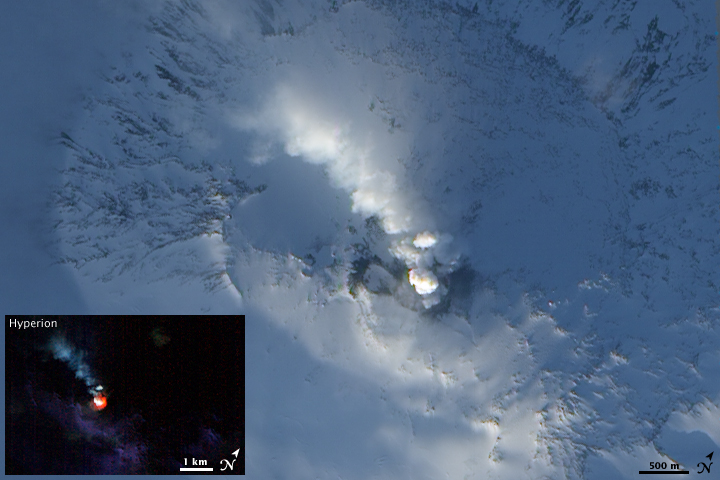
The summit consists of the elliptical 500 x 600 m wide, 110-m-deep crater, which contains the famous active lava lake, contained within a 250-m-wide, 100-m-deep inner crater.
Erebus lava lake
Mount Erebus is noted for its active anorthoclase-feldspar phonolite lava lake, which has been in continuous activity since at least 1972, but probably much longer. Mt Erebus volcano's lava lake is connected to a long-lived, open and stable magma plumbing system, which might have been in place for the past 17,000 years.
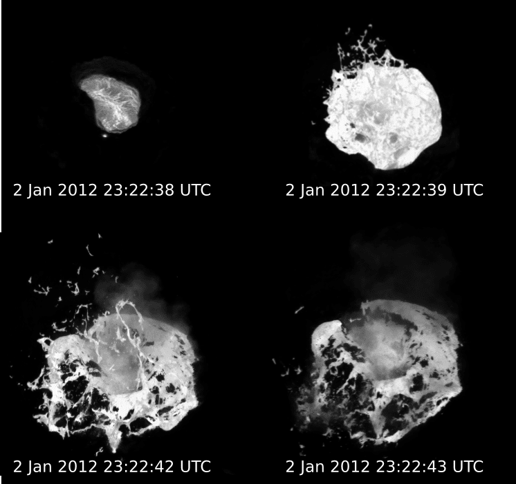
The current activity at the lava lake includes spattering and sometime strombolian explosions, that can eject bombs outside the crater.
Persistant lava lakes are very rare, and require a delicate equilibrium between heat supply and heat loss. Heat supply is provided by rising magmatic gasses from the magma chamber through a liquid-filled conduit, and is counterbalanced by intense heat lost at the surface of the lava lake. There are only a handful long-lived lava lakes in the world: at Erta Ale volcano (Ethiopia), Nyiragongo (DRCongo), Ambrym (Vanuatu), often on Kilauea volcano on Hawai'i, and only occasionally on other volcanoes.
Monitoring
Although Erebus is perhaps in among the most inhospitable and remote location of any active volcano in the world, it is relatively well monitored. The Mt. Erebus Volcano Observatory (MEVO), run by New Mexico Institute of Mining and Technology and the National Science Foundation, operates regular field surveys and measurements from McMurdo Station. There is even a webcam on the rim of the crater! Satellites monitor CO2, SO2 and other gasses emitted by Erebus, which influence the Antarctic atmosphere, which is of particular importance to global climate.
Sources, further reading and references
- Mt. Erebus Volcano Observatory
- Mt Erebus webcam
- Smithsonian / GVP volcano information
- Esser, R., Kyle, P., McIntosh, W. (2004) "40Ar/39Ar dating of the eruptive history of Mount Erebus, Antarctica: volcano evolution", Bulletin of Volcanology, v 66, pp 671-686.
- Zreda-Gostynska, G., Kyle, P., Finnegan, D., Prestbo, K.M. (1997) "Volcanic gas emissions from Mount Erebus and their impact on the Antarctic environment", Journal of Geophysical Research, v. 102, pp 15039-15055
Eruptions of Erebus volcano
Activity increased during the first half of 2006 and decreased after June again. During this period, there were frequent large and very large eruptions from the Lava Lake, Ash Vent, or Werner's Vent inside the inner crater.
Several "small- to medium-sized" (strombolian) eruptions were reported during 12-18 October, with a "very large" eruption on 14 October.
In early 2001, lava flows in the inner crater and ash eruptions were seen at Erebus volcano.
On 23 November 2001, MEVO reported that Mount Erebus produced frequent Strombolian eruptions (~1-10 per day) and the lava lake was 15 m in diameter. Small ash explosions also took place from a vent adjacent to the lava lake.
Activity was relatively uniform between 1980-1995, with the exception of 2 significant events: In 1984 there was a 3-4 month period of larger and more frequent Strombolian eruptions which ejected bombs >2 km from the summit crater.
On 19 October 1993, 2 moderate phreatic eruptions blasted a new crater ~80 m in diameter on the Main Crater floor and ejected debris over the northern Main Crater rim.
Significant collapse of the Inner Crater was occurring in late 1995, although the lava lake remained fairly constant in size at ~20 m diameter and generally in the same location.
(from Smithsonian / GVP monthly reports
An increase of the activity began on 13 September 1984 and peaked during the month and in early October, and remained at significantly higher levels than since 1972 until January 1985.
Previously, small Strombolian eruptions, which occurred 2-6 times/day, had occasionally ejected bombs from the 220-m-deep inner crater floor onto the main crater rim.
During the increased activity, bombs averaging 2 m long and reaching more than 10 m in length landed in all directions around the crater rim, and reached up to 1.2 km horizontal distance from the inner crater. The eruptions were witnessed from 60 km distance and the explosions could be heard from 2 km.
(adapted from Smithsonian / GVP monthly reports)
On 28 November 1979, an Air New Zealand sightseeing flight crashed into Mt Erebus, killing all 237 passengers and 20 crew on board. The accident is commonly known as the Mount Erebus disaster.
In 1976, it was noted that the lava lake had slowly increased since its discovery 4 years ago in 1972 and was about 100 m wide.
Throughout the 1970's, activity remained relatively constant, with a slight tendency of gradual increase in level. Strombolian eruptions were occurring from time to time, 2-10 per day typically, sometimes throwing bombs up to a few hundred meters above the outer rim. Occasionally, such bombs were landing outside the crater.
In 1978, the lake was 130 m wide and oval-shaped, with 2 zones of active upwelling of lava. Doming of the lava lake surface was occasionally observed, including one large bubble, that grew to ~80 m height before bursting.
In 1978, the lava lake activity consisted of 1) lava upwelling in nearly circular areas, 2) small bubble-like degassing eruptions, and 3) downwelling of the consolidated crust along planar troughs or 'subduction zones.'
Scientists tried to descend into the inner crater in order to collect fresh samples. On 23 December 1978, New Zealand volcanologist W. F. Giggenbach had almost reached the inner crater floor, when an explosion occurred. He was hit by a small bomb above his knee, but survived without injury; only the woolen pants were burnt.
Latest satellite images