Geophysical survey leads to visualization of magma chamber under Reykjanes Peninsula
Thu, 11 Mar 2021, 07:30 | BY: T
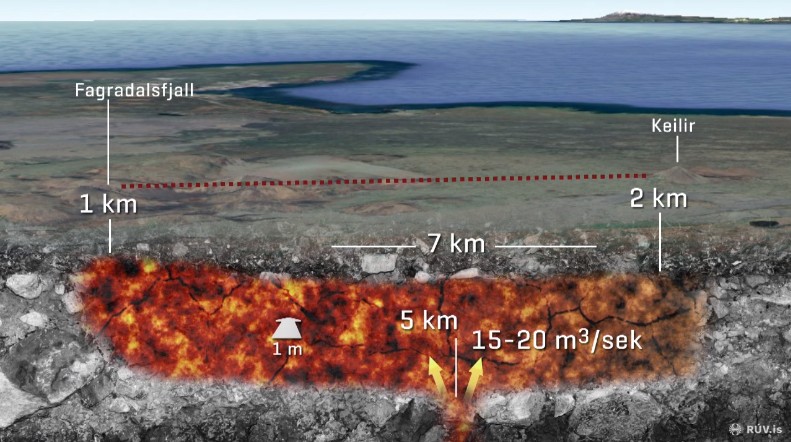
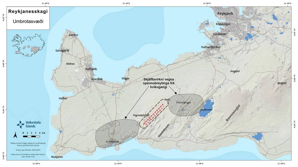
Sketch showing the forming magma reservoir, a dike, under the Reykjanes peninsula (image: RUV)
Geophysical surveys were conducted along the area of unrest located in between Fagradalsfjall and Keilir. The results generated a detailed look at how the expanding magma chamber under the Reykjanes peninsula behaves.
Expanding magma chamber under the Reykjanes peninsula
In an interview of the Icelandic National Broadcasting Service (RUV) with geophysicist Freysteinn Sigmundsson on 9 March 2021, the growing magma reservoir was shown to be in the form of a dike: It is currently about 1 meter wide and 7 kilometers long spanning the length between Keilir at the northern end and Fagradalsfjall at the southern end. The bottom of the magma chamber is located 5 kilometers below ground surface and is the site for magmatic influx. This is the process by which magma flows from deeper sources in the mantle towards the shallow magma chamber where it is now being stored.
15-20 cubic meters of magma flowing into the reservoir
Based on the rate of deformation, allowing to estimate the increase of volume of the dike, the magma influx was measured to be about 15 to 20 cubic meters per second.
The northern end of the magma chamber lies 2 kilometers deep under Keilir, while the southern end lies only a kilometer deep under Fagradalsfjall. Due to this orientation of the magma chamber, geophysicists believe that it is possible that the magma underneath Keilir may have already cooled down and solidified or is about to. An eruption in this area is thus less likely than in the area of the southern end of the dike, i.e. near Fagradalsfjall. It also means that there are more seismic and magmatic activities at the southern end near Fagradalsfjall.
Greatest volcano-seismic activity near Fagradalsfjall
According to geophysicist Sigmundsson, if magma continues to flow into the magma chamber, it will expand into the area with least resistance. This means that the magma chamber will expand southward as that portion is closer to the surface. Magma might eventually reach the surface causing an eruption near Fagradalsfjall. Scientists found evidence of magma migration such as increased seismic activities and ground deformation in the area.
However, there is still no way of knowing whether this scenario (of an eruption at the surface) becomes true, and if yes, what the exact date and time for an eruption in the area will be. There is still the possibility that the current volcano-seismic activity will weaken and no eruption occurs. But Sigmundsson believes that if an eruption does occur, it will be similar to the 2010 Fimmvorduhals fissure eruption, producing lava fountains and voluminous lava flows, but not followed by an explosive stage as there is no nearby glacier or larger water body that might interact.
For the complete interview with geophysicist Freysteinn Sigmundsson, visit the RUV news page here.
- All news about: Fagradalsfjall volcano
- Information about: Fagradalsfjall volcano
Previous news
Wed, 10 Mar 2021, 15:29
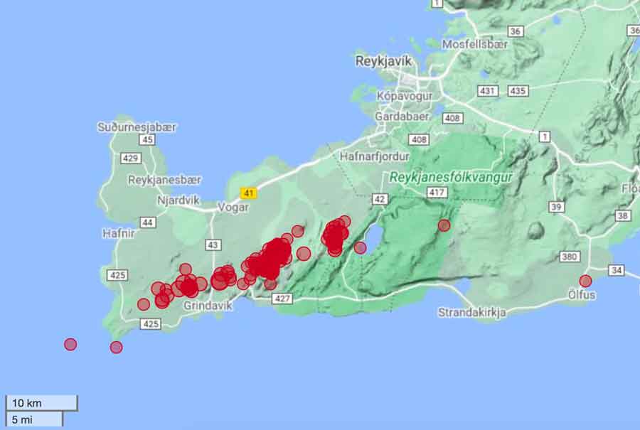
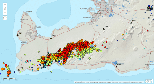
Fagradalsfjall volcano update: More than 34,000 quakes in two weeks
The Icelandic Met Office (IMO) announced earlier today, that the total number of earthquakes in the region has exceeded 34,000 since the onset of the seismic swarm about 2 weeks ago. Read all
Wed, 10 Mar 2021, 06:08
Fagradalsfjall volcano update: Aviation warning and future possibilities
As the number of earthquakes recorded in the Reykjanes Peninsula, Iceland, surpassed the 20,000 mark, the main area of unrest was identified as the area between Fagradalsfjall and Keillir. According to the Icelandic Meteorological Office (IMO), magma intrusions under the surface are the prime suspect to cause this ongoing seismic activity. ... Read all
Show more