Contact | RSS | EN | DE | EL | ES | FR | IT | RU

Fuego volcano (Guatemala): violent paroxysmal phase has ended / summary and video

Sat, 30 Jul 2016, 10:28 | BY: T
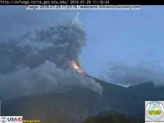
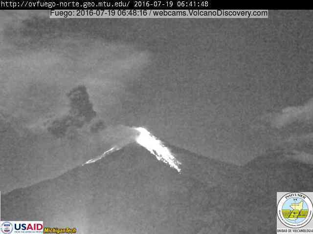
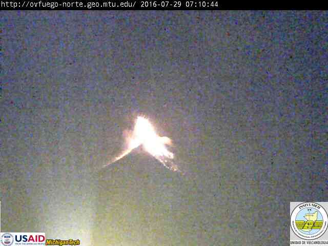
Ash plume from Fuego yesterday morning with lava fountains
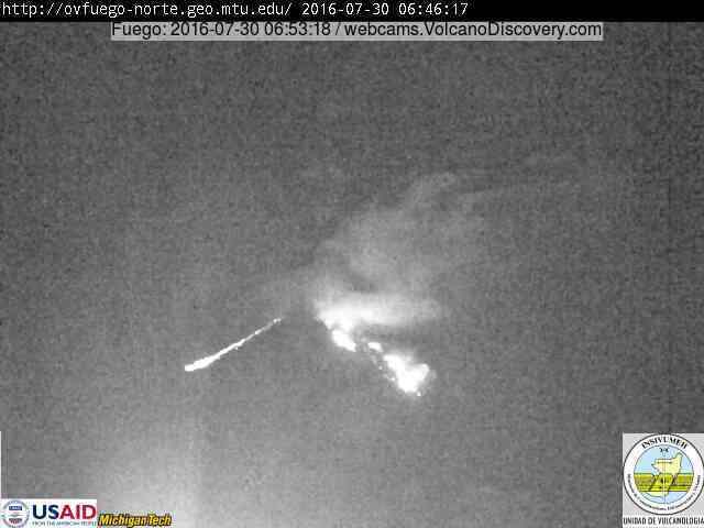
Fuego this morning with only remnants of the lava flow
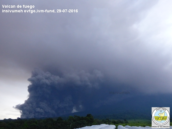
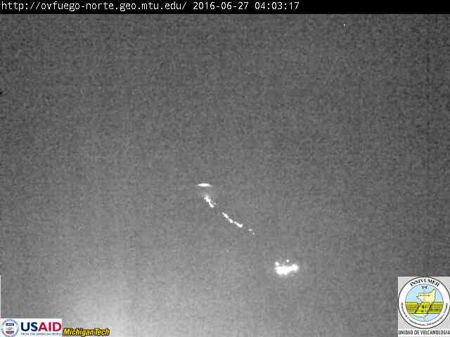
Pyroclastic flow at Fuego yesterday
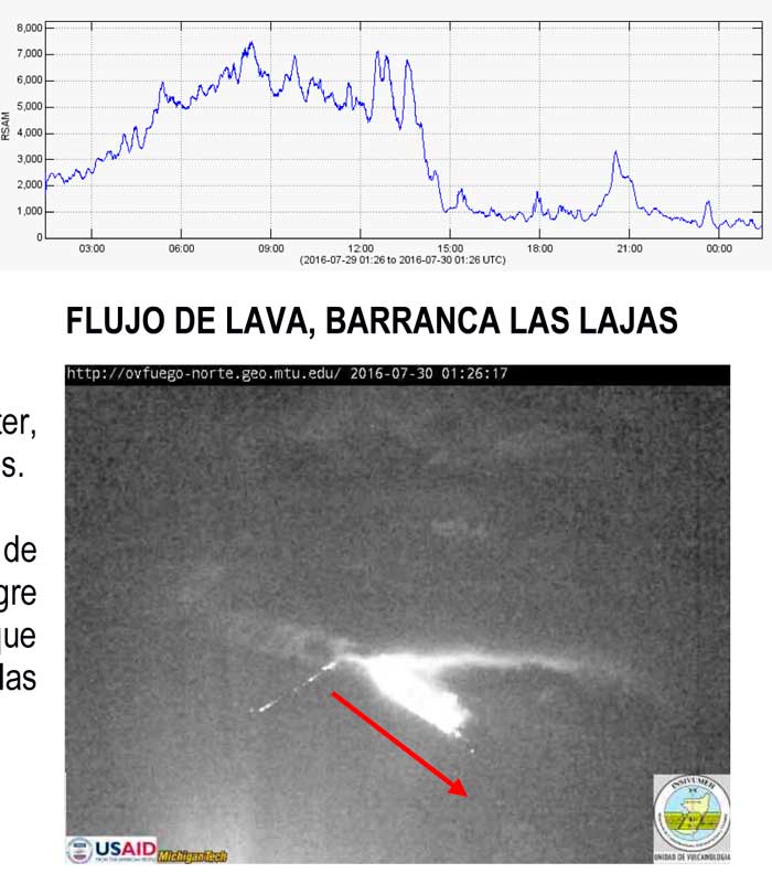
Tremor amplitude during the paroxysm and the lava flow (INSIVUMEH)
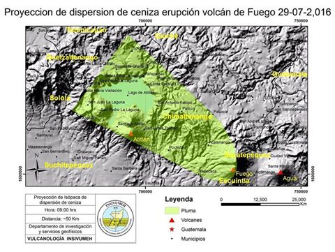
Area affected by ash fall (CONRED)
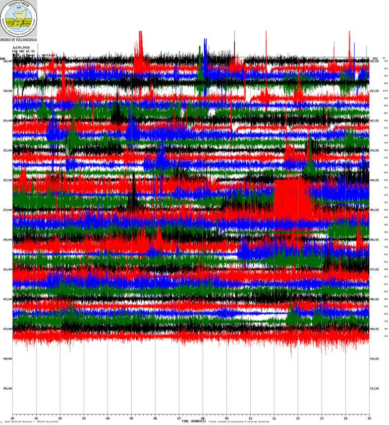
Current seismic signal FG3 station (INSIVUMEH)
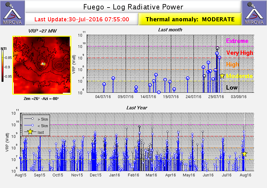
Heat signal from Fuego volcano (MIROVA)
The paroxysm at Fuego, which had reached its peak phase during the night of Thu-Fri (28-29 July) has ended. Starting from the early afternoon yesterday (local time), activity gradually decreased and the volcano's activity has by now returned to intermittent smaller strombolian explosions.
The lava effusion dropped as well. As of yesterday evening, the two lava flows on the SE side were still active and 1500 m long while explosions at the vent were still reaching 400 meters height; by this morning, the lava flows continued to be active, but had decreased to a few hundred of meters length and are probably going to stop soon.
(Video of the eruption at end of article)

The recent paroxysmal eruptive phase (the 12th in 2016) with pulsating lava fountains and continuous ash emissions had lasted approx. 12 hours at its climax during the night 28-29 and morning of 29 July. It was described as one of the strongest so far this year.
This is also reflected by the thermal heat signal measured via satellite and the fact that it generated pyroclastic flows on several sides of the volcano (by collapsing parts of the lava flows and/or ejecta from the summit). A relatively large one can be seen descending to the western foot of the volcano on the webcam image on the SW side from yesterday morning.
CONRED (Guatemala's Civil Protection) had declared Orange alert for the Yepocapa municipality.
Another indication of the strength of the eruption was the relatively large amount of ash emitted. The ash plumes during the eruption reached 15-20,000 ft (4.5-6 km) altitude, i.e. 2000-2500 meters above the summit and drifted to the west, where moderate to strong ash fall occurred in distances up to approx. 20 km.

Previous news

Fri, 29 Jul 2016, 07:26

Fuego volcano (Guatemala): 12th paroxysm in 2016 in progress

Lava fountaining from Fuego volcano this morning
Another intense eruptive phase with strong explosions, lava fountaining and abundant lava flow activity is in progress at the volcano. ... Read all
Wed, 27 Jul 2016, 06:00

Fuego volcano (Guatemala) - Smithsonian / USGS Weekly Volcanic Activity Report for 27 July-2 August 2016 (New Activity / Unrest)

On 28 July CONRED noted that in recent days activity at Fuego was characterized by a high level of explosive activity. At 0545 activity increased further, heralding a shift to Strombolian activity and the beginning of the 12th eruptive episode at Fuego in 2016. Explosions produced ash plumes that rose 1 km and drifted 15 km SW, W, and NW, and caused shock waves detected in nearby areas. ... Read all
Show more
Fuego volcano
Stratovolcano 3,763 m / 12,346 ft
Guatemala, 14.47°N / -90.88°W
Current status: erupting (4 out of 5) Fuego volcano eruptions:
1581, 1585, 1586, 1587, 1614, 1617, 1620, 1623, 1629, 1679(?), 1685, 1686, 1689(?), 1699, 1702, 1705, 1706, 1709(?), 1710,1717,1730, 1732, 1737, 1751(?), 1765(?), 1773(?), 1799, 1826, 1829, 1850(?), 1852(?), 1855, 1856, 1857, 1860, 1861(?), 1867(?), 1880, 1896, 1932, 1944, 1949, 1953, 1955, 1957, 1962, 1963, 1966, 1967, 1971, 1973, 1974, 1975, 1977, 1987, 1999, 2002 - ongoing
Typical eruption style
Dominantly explosive, construction of lava domes and extrusion of viscous lava flows. In near constant activity, at least during the past centuries.
Fuego Volcano Tours
11-day volcano tour to Pacaya and Fuego, Guatemala
8-12 days - Moderate to Challenging
Price $ 3490
no scheduled dates at present
Satellite image of Fuego volcano by (c) Google Earth View
Try our free app!
Volcanoes & Earthquakes - new app for Android
Android | iOS version

More on VolcanoDiscovery

Why is there advertising on this site?

Support us - Help us upgrade our services!

We truly love working to bring you the latest volcano and earthquake data from around the world. Maintaining our website and our free apps does require, however, considerable time and resources.
We need financing to increase hard- and software capacity as well as support our editor team. We're aiming to achieve uninterrupted service wherever an earthquake or volcano eruption unfolds, and your donations can make it happen! Every donation will be highly appreciated. If you find the information useful and would like to support our team in integrating further features, write great content, and in upgrading our soft- and hardware, please make a donation (PayPal or Online credit card payment).

Planned features:Thanks to your past donations, these features have been added recently:
Download and Upgrade the Volcanoes & Earthquakes app to get one of the fastest seismic and volcano alerts online:
Android | IOS
Thank you!
Sources: VolcanoDiscovery / VolcanoAdventures and other sources as noted.
Use of material: Most text and images on our websites are owned by us. Re-use is generally not permitted without authorization. Contact us for licensing rights.
Volcanoes & Earthquakes
VolcanoDiscovery Home
Volcanoes | Earthquakes | Photos | Volcano News | App
Adventure & Study Travel
Tours to Volcanoes and Volcanic Areas: walking tours, photo tours, study tours
Tours & Dates | FAQ | About us
Get our newsletter!
Company info
Contact | Legal info | Terms & conditions
Follow us
Follow us on facebook Follow us on Instagram Follow us on Twitter Visit our Youtube channel
EN | DE | EL | ES | FR | IT | RU
VolcanoDiscovery GmbH, Germany, Reg. nr.: HRB 103744, EU Tax Id: DE 297 465 123 owned and created by
Dr. Tom Pfeiffer, volcanologist, volcano photographer, tour organizer member of
IAVCEI
IAVCEI
Vulkanologische Gesellschaft
Volcanological Society
Ecotourism Greece
Ecotourism Greece
RUV insurance
Insured by R+V
VolcanoDiscovery © 2004- All Rights Reserved | Privacy - Cookie Settings