(caldera 1499 m / 4,918 ft)
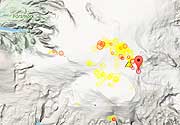
Akan volcano (阿寒岳, Akan-dake) is one of Hokkaido's most active volcanoes. Akan consists of a large 24 x 13 km diameter caldera and a group of younger partly Holocene andesite cones. The highest point of the complex is the Mount Meakan (1499 m) stratovolcano.
The frequent hi... [
more info]
(Stratovolcano(es) 554 m / 1818 ft)
[
more info]
(stratovolcano 2290 m / 7,513 ft)
Daisetsu (also spelled Taisetsu or Taisetsuzan) volcano is a group of 8 stratovolcanoes, lava domes and a small 2 km wide caldera in the Daisetsu-zan National Park (the roof of Hokkaido) in central Hokkaido.
Asahi (旭岳 Asahi-dake) volcano is the highest peak of the vo... [
more info]
(stratovolcano / lava dome 618 m / 2,028 ft)
E-san (恵山(えさん) in Japanese) is the southernmost active volcano on Hokkaido. It is a small andesitic stratovolcano located in the southeast of the Kameda-hanto Peninsula extending into the Pacific Ocean from the south of Hokkaido across the Tsugaru Strait from Honshu.
It ha... [
more info]
(Stratovolcano(es) 1322 m / 4337 ft)
[
more info]
(stratovolcano 1131 m / 3,711 ft)
Komaga-take volcano (北海道駒ヶ岳) is one of Japan's most active volcanoes. It is located on the Oshima Peninsula of southern Hokkaido. The volcano is known for its violent and explosive, including Plinian eruptions. [
more info]
(Stratovolcano(es) 1635 m / 5364 ft)
[
more info]
(caldera 999 m / 3,278 ft)
Kutcharo (also spelled Kussharo or Kuccharo) is the largest of a cluster of calderas in NE Hokkaidoo, Japan, and contains
Atosanupuri (アトサヌプリ) volcano.
The caldera formed during a series of major explosive eruptions between 340,000 and 30,000 years ago. The crescent... [
more info]
(stratovolcanoes 581 m / 1,906 ft)
Kuttara volcano is a group of small stratovolcanoes, lava domes, pyroclastic cones and a caldera near the Pacific coast SE of Toya caldera and SW of Shikotsu caldera in southern Hokkaido, Japan.
The area is known for some spectacular volcanic scenery:
Lake Kuttara... [more info]
(caldera 855 m / 2,805 ft)
Mashu volcano is a 7 km wide caldera in NE Hokkaido, Japan.
The caldera formed ca. 7000 years ago and truncates a stratovolcano which formed the ESE rim of the large Kutcharo caldera to the west. The steep-walled Mashu caldera contains Lake Mashu (摩周湖 Mashū-ko), known for ... [
more info]
(Stratovolcano(es) 1006 m / 3301 ft)
[
more info]
(caldera, hydrothermal field 356 m / 1,168 ft)
Nigorigawa (also spelled Nigorikawa) volcano is a geothermal field (Mori geothermal field) in the 3 km diameter Nigorikawa caldera on the shores of Uchiura Bay, southern Hokkaido, Japan. The caldera was formed during a major explosive eruption ca. 12,000 years ago. [
more info]
(stratovolcanoes, lava domes 2013 m / 6,604 ft)
Nipesotsu-Maruyama volcano is a group of overlapping stratovolcanoes and lava domes located east of Nukabira Lake and about 20 km east of Tokachi-dake volcano on Hokkaido Island, Japan.
The only historic eruption was a minor phreatic explosion from Maru-yama ("round mounta... [
more info]
Niseko volcano (ニセコ火山群 Niseko-kazangun) is a group of stratovolcanoes and lava domes NW of Niseko city. The latest eruption of Niseko was a phreatic or magmatic eruption ca. 7000 years ago. At present, there is geothermal activity including hot springs and fumaroles at various lo... [
more info]
(Stratovolcano(es) 1231 m / 4039 ft)
[
more info]
(stratovolcano 737 m / 2,418 ft)
Oshima-Oshima volcano (渡島大島 in Japanese) forms a small uninhabited 4 km wide island in the Japan Sea island 55 km west of the SW tip of Hokkaido in northern Japan. Oshima-Oshima's eruption in 1741 caused a tsunami that killed almost 1500 people. [
more info]
(Stratovolcano(es) 1212 m / 3976 ft)
[
more info]
(stratovolcano 1660 m / 5,446 ft)
Rausu volcano (羅臼岳 Rausudake) is an active stratovolcano on the Shiretoko Peninsula of NE Hokkaido. It is located on a ridge 5 km SW of Shiretoko-Iwo-san volcano, the NE-most active volcano in Hokkaido.
Rausu's summit contains lava domes. Young lava flows are visible on the... [
more info]
(stratovolcano 1721 m / 5,646 feet)
Rishiri volcano (利尻山, Rishiri-zan) forms is a small island about 20 kilometers west of the northern tip of Hokkaido. The andesitic stratovolcano last erupted ca. 8500 years ago and is strongly eroded. Erosion has sculptured a sharp-topped summit and steep radial ridges. The lates... [
more info]
(lava domes 1401 m / 4,596 ft)
Shikaribetsu volcano (然別火山群 Shikaribetsu-kazangun) is a group of lava domes west and south of Lake Shikaribetsu in central Hokkaido. They are part of the Daisetsuzan National Park. The volcanic group includes the peaks of Mount Ishikari (highest), Mount Yuniishikari, Mount Otofuk... [
more info]
(caldera 1320 m / 4,331 ft)
Shikotsu volcano is the large 15 x 13 km diameter caldera containing 360 m deep Lake Shikotsu (支笏湖 Shikotsu-ko), Japan's second largest crater lake and the northernmost lake which doesn't feeeze over in winter.
The small andesitic Tarumai (Tarumae, 樽前山 Tarumae-zan) stratovo... [
more info]
(stratovolcano 1563 m / 5,128 ft)
Shiretoko-Iozan (Shiretoko-Iwo-zan) volcano is an active stratovolcano on the NE tip of Hokkaido on the Shiretoko Peninsula. It is known as one of the many Japanese "sulfur mountains". During eruptions in 1936 and 1889, the volcano erupted molten sulfur.
The Shiretoko Peni... [
more info]
(lava dome 1107 m / 3,632 ft)
Shiribetsu-dake volcano is located SE of Yotei volcano in SW Hokkaido. The andesitic lava dome contains a 1.5 km diameter summit crater breached to the west. The last eruptions were several hundred thousand years ago. [
more info]
(crater rows 1,046 m / 3,432 ft)
Phreatic eruptions at Tenchozan occurred approximately 1,900 years ago. Towards the end of those eruptions there was a phreatomagmatic or small magmatic eruption. The chain of explosion craters, stretching from the NE to the SW, are considered to be a result of this series of eru... [
more info]
(Stratovolcano(es) 1796 m / 5892 ft)
[
more info]
(stratovolcanoes 2077 m / 6,814 ft)
Tokachi volcano (十勝岳 Tokachidake) is a group of stratovolcanoes and lava domes in central Hokkaido, Japan.
Frequent historical eruptions were mostly small to moderate phreatic explosions (VEI 1-2) and cluster in 5 periods: 1857, 1887 and 1889, 1925-1931, 1952 to 1962, and ... [
more info]
(Stratovolcano(es) 2141 m / 7024 ft)
[
more info]
(stratovolcano 737 m / 2,418 ft)
Mt Usu (有珠山) or Usu-zan volcano is Hokkaido is one of Japan's most well-known volcanoes, part of the active Toya caldera. The summit of Usu consists of several lava domes that formed in historic time.
The last eruption was in March 2000 - September 2001, when Usu erupted fo... [
more info]
(stratovolcano 1898 m / 6,227 ft)
Yotei volcano (羊蹄山 Yōteizan) is a symmetrical andesitic-to-dacitic stratovolcano NW of Usu volcano on southern Hokkaido, Japan. The summit contains a 700 m wide crater and its flanks are cut by deep erosion gullies. The last eruption of the summit crater was about 5-6000 years ag... [
more info]