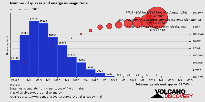
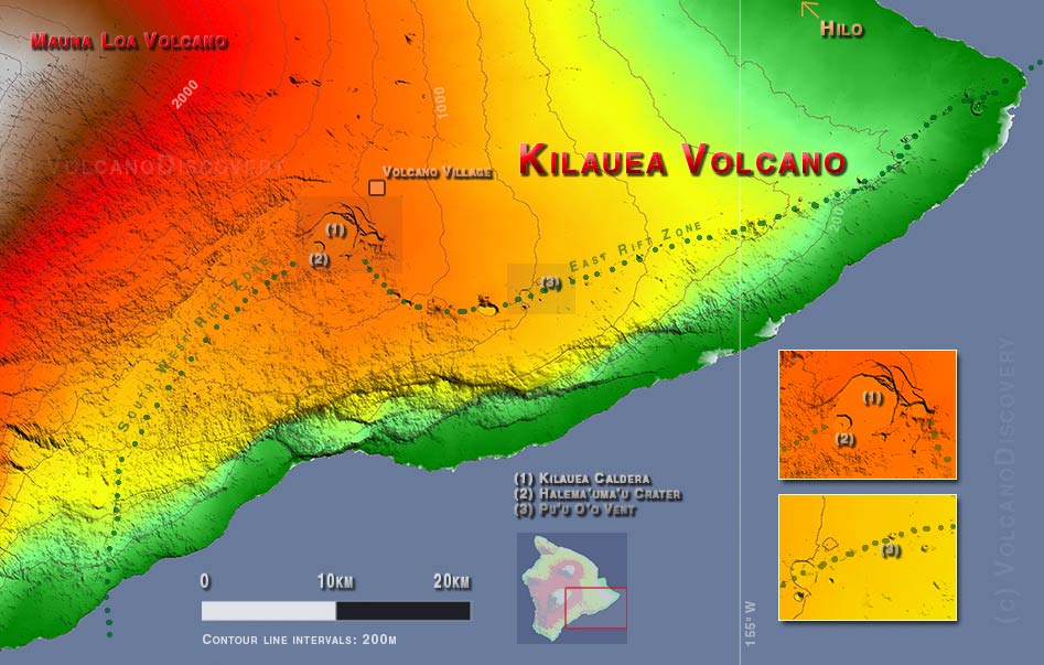
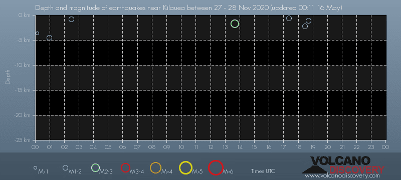
Contact | RSS | EN | DE | EL | ES | FR | IT | RU

Past earthquakes near Kilauea volcano: Nov 27, 2020 - list, stats and map

Updated: Apr 26, 2024 14:19 GMT -
On Friday, November 27th, 2020, Kilauea volcano has had 14 quakes of magnitudes up to 2.4:
  • 8 quakes above magnitude 2
  • 6 quakes below magnitude 2 that people normally don't feel.
Strongest: Mag. 2.4 Earthquake 15 Km S of Fern Forest, Hawaii, USA -
[smaller] [bigger]

Quakes, magnitude and depth over time

Earthquake depth plot
Depth and magnitude of quakes over time
Filter by magnitude:
all
1.0+
2.0+
Showing quakes magnitude 0.5 or higher, within up to 30 km (19 mi) distance (14 quakes):
Past earthquakes near Kilauea volcano: Nov 27, 2020 - list, stats and map
Date and TimeMag
Depth
DistanceLocationDetailsMap
Nov 27, 2020 01:34 pm (Honolulu)
2.3

34 km
27 km (17 mi) to the SW 2 mi northeast of Pāhala, Hawaii, USA
Info
Nov 27, 2020 12:26 pm (Honolulu)
2.0

32 km
23 km (14 mi) to the SW 5.2 mi northeast of Pāhala, Hawaii County, USA
Info
Nov 27, 2020 08:42 am (Honolulu)
1.8

1.1 km
2.1 km (1.3 mi) to the NE County, 3 mi southwest of Volcano Village (Hawaii County), Hawaii, USA
Info
Nov 27, 2020 08:26 am (Honolulu)
1.8

2.2 km
18 km (11 mi) to the SE 9.8 mi southeast of Volcano Village, Hawaii County, USA
Info
Nov 27, 2020 07:21 am (Honolulu)
1.9

0.6 km
3.1 km (1.9 mi) to the SW 6.2 mi southwest of Volcano Village, Hawaii County, USA
Info
Nov 27, 2020 03:38 am (Honolulu)
2.4

1.7 km
18 km (11 mi) to the SE 10.3 mi southeast of Volcano Village, Hawaii County, USA
Info
Nov 26, 2020 06:13 pm (Honolulu)
2.3

31 km
20 km (13 mi) to the SW 6.9 mi northeast of Pāhala, Hawaii County, USA
Info
Nov 26, 2020 06:00 pm (Honolulu)
2.1

32 km
22 km (14 mi) to the SW 6.2 mi east of Pāhala, Hawaii County, USA
Info
Nov 26, 2020 05:54 pm (Honolulu)
2.1

32 km
21 km (13 mi) to the SW 7 mi east of Pāhala, Hawaii County, USA
Info
Nov 26, 2020 04:56 pm (Honolulu)
2.2

33 km
21 km (13 mi) to the SW 6.7 mi northeast of Pāhala, Hawaii County, USA
Info
Nov 26, 2020 04:27 pm (Honolulu)
1.8

0.8 km
18 km (10.9 mi) to the SE 9.7 mi southeast of Volcano Village, Hawaii County, USA
Info
Show more
About these data
Estimated combined seismic energy released: 1.3 x 10⁹ joules (351 kilowatt hours, equivalent to 0.302 tons of TNT) | about seismic energy

Earthquake Catalog - Look up past earthquakes

Look up past earthquakes in this area by date or date range:
or
Look up quakes!
Felt a quake? Report it!
Show quakes near me!

Earthquake statistics

Number of earthquakes over time

on Friday, November 27th, 2020
during November 2020
in 2020
Number of earthquakes over time: on Friday, November 27th, 2020
Number of earthquakes over time: during November 2020
Number of earthquakes over time: in 2020

Magnitude and seismic energy over time

on Friday, November 27th, 2020
during November 2020
in 2020
Magnitude and seismic energy over time: on Friday, November 27th, 2020
Magnitude and seismic energy over time: during November 2020
Magnitude and seismic energy over time: in 2020

Magnitude and energy distribution

on Friday, November 27th, 2020
during November 2020
in 2020
Magnitude and energy distribution: on Friday, November 27th, 2020
Magnitude and energy distribution: during November 2020
Magnitude and energy distribution: in 2020

Embed or share standalone map

You can use the standalone version of our interactive earthquake map or embed it on your website:
Wed, 7 Feb 2024, 15:00

Kilauea volcano (Hawaiian Islands, USA) - Smithsonian / USGS Weekly Volcanic Activity Report for 31 January-6 February 2024 (New Activity / Unrest)

HVO reported that seismicity at Kilauea increased on 27 January and during 27-30 January the locations of the earthquakes became more widespread. Inflation at the summit was ongoing and remained at a high level. Sulfur dioxide gas emission rates were low. ... Read all
Sun, 4 Feb 2024, 05:20

Kilauea volcano update: alert level lowered to Yellow as activity has waned significantly

The earthquake activity beneath the Southwest Rift Zone over the past two hours (image: HVO)
The seismic activity and ground deformation at the volcano have significantly decreased. ... Read all
Satellite photo of Kilauea volcano, showing the summit caldera and parts of its east rift zone with the active vent Pu'u 'O'o.
Three-dimesional view of Kilauea volcano based on satellite imagery.

Map of Kilauea volcano, Big Island Hawai'i
Try our free app!
Volcanoes & Earthquakes - new app for Android
Android | iOS version

More on VolcanoDiscovery

Why is there advertising on this site?

Support us - Help us upgrade our services!

We truly love working to bring you the latest volcano and earthquake data from around the world. Maintaining our website and our free apps does require, however, considerable time and resources.
We need financing to increase hard- and software capacity as well as support our editor team. We're aiming to achieve uninterrupted service wherever an earthquake or volcano eruption unfolds, and your donations can make it happen! Every donation will be highly appreciated. If you find the information useful and would like to support our team in integrating further features, write great content, and in upgrading our soft- and hardware, please make a donation (PayPal or Online credit card payment).

Planned features:Thanks to your past donations, these features have been added recently:
Download and Upgrade the Volcanoes & Earthquakes app to get one of the fastest seismic and volcano alerts online:
Android | IOS
Thank you!
Sources: VolcanoDiscovery / VolcanoAdventures and other sources as noted.
Use of material: Most text and images on our websites are owned by us. Re-use is generally not permitted without authorization. Contact us for licensing rights.
Volcanoes & Earthquakes
VolcanoDiscovery Home
Volcanoes | Earthquakes | Photos | Volcano News | App
Adventure & Study Travel
Tours to Volcanoes and Volcanic Areas: walking tours, photo tours, study tours
Tours & Dates | FAQ | About us
Get our newsletter!
Company info
Contact | Legal info | Terms & conditions
Follow us
Follow us on facebook Follow us on Instagram Follow us on Twitter Visit our Youtube channel
EN | DE | EL | ES | FR | IT | RU
VolcanoDiscovery GmbH, Germany, Reg. nr.: HRB 103744, EU Tax Id: DE 297 465 123 owned and created by
Dr. Tom Pfeiffer, volcanologist, volcano photographer, tour organizer member of
IAVCEI
IAVCEI
Vulkanologische Gesellschaft
Volcanological Society
Ecotourism Greece
Ecotourism Greece
RUV insurance
Insured by R+V
VolcanoDiscovery © 2004- All Rights Reserved | Privacy - Cookie Settings