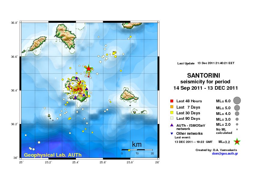
Contact | RSS | EN | DE | EL | ES | FR | IT | RU

Past earthquakes near Kolumbo volcano: 2020 - list, stats and map

Updated: Apr 19, 2024 01:08 GMT -
In 2020, Kolumbo volcano has had 15 quakes of magnitudes up to 2.8:
  • 13 quakes above magnitude 2
  • 2 quakes below magnitude 2 that people normally don't feel.
Strongest: Mag. 2.8 Earthquake Dodecanese Islands, Greece -
[smaller] [bigger]

Quakes, magnitude and depth over time

Earthquake depth plot
Depth and magnitude of quakes over time
Filter by magnitude:
all
2.0+
Showing quakes magnitude 0.5 or higher, within up to 30 km (19 mi) distance (15 quakes):
Past earthquakes near Kolumbo volcano: 2020 - list, stats and map
Date and TimeMag
Depth
DistanceLocationDetailsMap
Dec 20, 2020 05:41 am (Athens)
2.3

6.1 km
25 km (15 mi) to the S Aegean Sea, 14 km southeast of Santorini Island, South Aegean, Greece
Info
Friday, December 18, 2020 GMT (1 quake)
Dec 18, 2020 09:45 pm (Athens)
2.4

9 km
1.1 km (0.7 mi) to the N Aegean Sea, 15 km north of Messaria, South Aegean, Greece
Info
Wednesday, December 2, 2020 GMT (1 quake)
Dec 2, 2020 07:15 pm (Athens)
2.6

8 km
8.9 km (5.5 mi) to the S Aegean Sea, 8 km northeast of Messaria, South Aegean, Greece
Info
Monday, September 21, 2020 GMT (2 quakes)
Sep 21, 2020 06:34 pm (Athens)
2.4

12 km
29 km (18 mi) to the E Aegean Sea, 34 km east of Messaria, South Aegean, Greece
Info
Sep 21, 2020 06:34 pm (Athens)
2.2

5 km
21 km (13 mi) to the NE Aegean Sea, 32 km northeast of Messaria, South Aegean, Greece
Info
Saturday, May 30, 2020 GMT (1 quake)
May 30, 2020 06:16 am (Athens)
1.5

8 km
25 km (15 mi) to the NE (Greece)
Info
Tuesday, May 12, 2020 GMT (1 quake)
May 12, 2020 02:19 pm (Athens)
2.2

10 km
27 km (17 mi) to the S (Greece)
Info
Tuesday, May 5, 2020 GMT (2 quakes)
May 5, 2020 08:24 pm (Athens)
2.7

4 km
28 km (17 mi) to the SE Dodecanese Islands, Greece
Info
May 5, 2020 03:46 am (Athens)
2.0

8 km
29 km (18 mi) to the S (Greece)
Info
Wednesday, April 29, 2020 GMT (1 quake)
Apr 29, 2020 04:06 am (Athens)
1.9

9 km
29 km (18 mi) to the E (Greece)
Info
Sunday, April 19, 2020 GMT (1 quake)
Apr 19, 2020 03:15 am (Athens)
2.1

5.1 km
25 km (16 mi) to the SE Mediterranean Sea (Greece)
Info
Show more
About these data
Estimated combined seismic energy released: 4.9 x 10⁹ joules (1.36 megawatt hours, equivalent to 1.17 tons of TNT) | about seismic energy

Earthquake Catalog - Look up past earthquakes

Look up past earthquakes in this area by date or date range:
or
Look up quakes!
Felt a quake? Report it!
Show quakes near me!

Earthquake statistics

Number of earthquakes over time

in 2020
Number of earthquakes over time: in 2020

Magnitude and seismic energy over time

in 2020
Magnitude and seismic energy over time: in 2020

Magnitude and energy distribution

in 2020
Magnitude and energy distribution: in 2020

Embed or share standalone map

You can use the standalone version of our interactive earthquake map or embed it on your website:
Tue, 20 Apr 2021, 18:13

Moderate earthquake near undersea volcano beside Santorini, Greece. Should we worry?

This morning's earthquake near Kolumbo volcano offshore Santorini
This morning, a magnitude 4.0 earthquake occurred 10 km northeast of Santorini Island. The quake hit at 11.21 am local time. It was felt by many people on Santorini, especially in the northern part of the island in the town of Oia, mostly as weak shaking that lasted a few seconds. ... Read all
Tue, 13 Dec 2011, 22:20

Kolumbos submarine volcano (Santorini, Greece): 3.2 magnitude earthquake

Map of recent earthquakes beneath Santorini, showing the 3.2 event at Kolumbos volcano NE of Santorini
At 19h22 GMT (21h22 local time), a 3.2 earthquake occurred at the little-known submarine volcano Kolumbos ca. 8 km NE of Santorini, Island, Greece. This marks one of the largest events in recent months. ... Read all
Map of the Kolumbo submarine crater and other submarine cones on the north-east trending Kolumbo volcano-tectonic rift. Figure courtesy of Haraldur Sigurdsson, Steven Carey, Matina Alexandir and Katy Croff. (from: http://oceanexplorer.noaa.gov/explorations/06blacksea/logs/summary_thera/summary_thera.html)
Map of the Kolumbo submarine crater and other submarine cones on the north-east trending Kolumbo volcano-tectonic rift. Figure courtesy of Haraldur Sigurdsson, Steven Carey, Matina Alexandir and Katy Croff. (from: oceanexplorer.noaa.gov/explorations/06blacksea/logs/summary_thera/summary_thera.html)
Try our free app!
Volcanoes & Earthquakes - new app for Android
Android | iOS version

More on VolcanoDiscovery

Why is there advertising on this site?

Support us - Help us upgrade our services!

We truly love working to bring you the latest volcano and earthquake data from around the world. Maintaining our website and our free apps does require, however, considerable time and resources.
We need financing to increase hard- and software capacity as well as support our editor team. We're aiming to achieve uninterrupted service wherever an earthquake or volcano eruption unfolds, and your donations can make it happen! Every donation will be highly appreciated. If you find the information useful and would like to support our team in integrating further features, write great content, and in upgrading our soft- and hardware, please make a donation (PayPal or Online credit card payment).

Planned features:Thanks to your past donations, these features have been added recently:
Download and Upgrade the Volcanoes & Earthquakes app to get one of the fastest seismic and volcano alerts online:
Android | IOS
Thank you!
Sources: VolcanoDiscovery / VolcanoAdventures and other sources as noted.
Use of material: Most text and images on our websites are owned by us. Re-use is generally not permitted without authorization. Contact us for licensing rights.
Volcanoes & Earthquakes
VolcanoDiscovery Home
Volcanoes | Earthquakes | Photos | Volcano News | App
Adventure & Study Travel
Tours to Volcanoes and Volcanic Areas: walking tours, photo tours, study tours
Tours & Dates | FAQ | About us
Get our newsletter!
Company info
Contact | Legal info | Terms & conditions
Follow us
Follow us on facebook Follow us on Instagram Follow us on Twitter Visit our Youtube channel
EN | DE | EL | ES | FR | IT | RU
VolcanoDiscovery GmbH, Germany, Reg. nr.: HRB 103744, EU Tax Id: DE 297 465 123 owned and created by
Dr. Tom Pfeiffer, volcanologist, volcano photographer, tour organizer member of
IAVCEI
IAVCEI
Vulkanologische Gesellschaft
Volcanological Society
Ecotourism Greece
Ecotourism Greece
RUV insurance
Insured by R+V
VolcanoDiscovery © 2004- All Rights Reserved | Privacy - Cookie Settings