Contact | RSS | EN | DE | EL | ES | FR | IT | RU

Korovin Volcano

Updated: Apr 24, 2024 22:10 GMT -
Stratovolcano 1533 m / 5030 ft
Andreanof Islands, Aleutian Islands, 52.38°N / -174.17°W
Current status: normal or dormant (1 out of 5)
Last update: 10 Dec 2021 (Volcanic Alert Level lowered to Green)

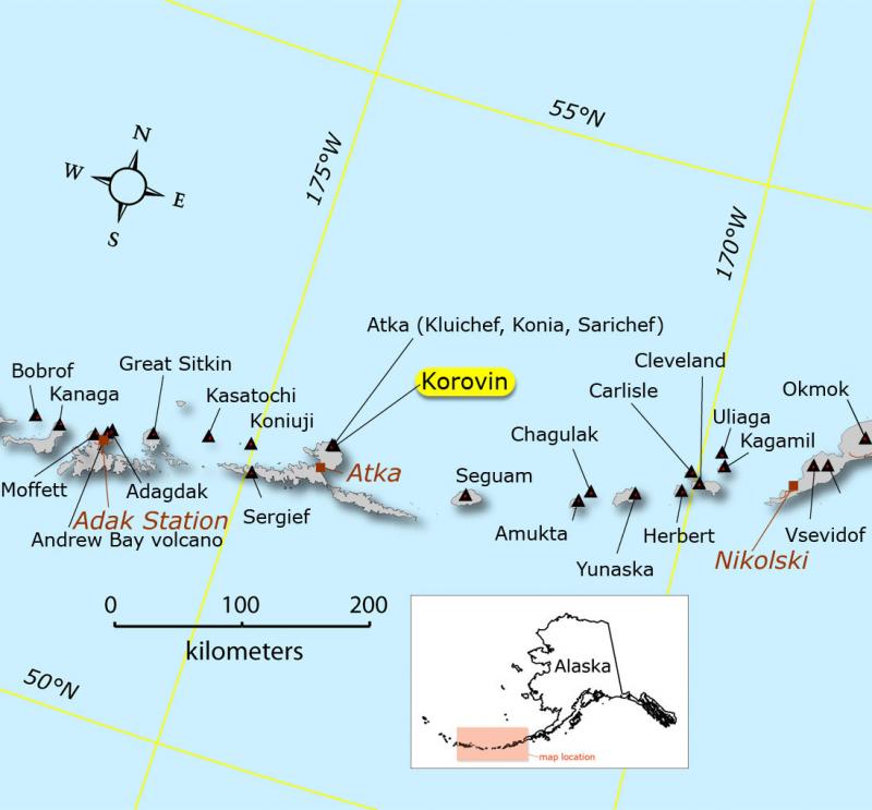
Korovin is a 1533 m high stratovolcano in the central Aleutian Islands and one of the most active volcanoes in Alaska. On average, it has been active every 10-15 years, its last eruption being in Nov-Dec 2006 with ash emissions.

[smaller] [larger]
Typical eruption style: Explosive
Korovin volcano eruptions: 1829(?), 1844(?), 1907(?), 1951(?), 1953(?), 1973, 1976(?), 1986(?), 1987, 1998, 2005, 2006

Latest nearby earthquakes

TimeMag. / DepthDistance / Location
Apr 21, 01:16 am (Adak)
3.3

14 km
9.7 km (6 mi) to the SE 16 km NE of Atka, Alaska  I FELT IT
Info
Friday, April 19, 2024 GMT (1 quake)
Apr 19, 08:14 am (Adak)
0.6

8.6 km
12 km NE of Atka, Alaska
Info
Monday, April 15, 2024 GMT (1 quake)
Apr 15, 11:54 am (Adak)
1.0

5.5 km
19 km N of Atka, Alaska
Info
Saturday, April 13, 2024 GMT (1 quake)
Apr 12, 05:24 pm (Adak)
0.6

6.6 km
16 km NNE of Atka, Alaska
Info
Friday, April 12, 2024 GMT (2 quakes)
Apr 12, 08:19 am (Adak)
0.5

3.6 km
13 km NNE of Atka, Alaska
Info
Apr 12, 04:05 am (Adak)
0.6

2.9 km
13 km N of Atka, Alaska
Info

Background

Geologically, Korovin belongs to the Atka volcanic complex on northern Atka Island. The Atka complex comprises a broad ancient central shield volcano, upon which a larger stratovolcano had been built destroyed by caldera formation about 300,000 to 500,000 years ago.
Korovin has two summit vents 0.6 km apart. The northwestern summit vent is a symmetric cone with a small crater. The southeastern summit vent is on the remnant of a cone with a steep-walled crater, about 1 km wide at the rim and at least several hundred meters deep with vertical crater walls. It contains a turquoise green lake with solfataric activity.

Latest satellite images

Korovin satellite image sat1Korovin satellite image sat2
Location of Korovin volcano (map created by Janet Schaefer, courtesy of Alaska Volcano Observatory / Alaska Division of Geological & Geophysical Surveys)
Fri, 4 Dec 2020, 08:59

Korovin volcano (Andreanof Islands, Aleutian Islands): Volcanic Alert Level lowered to Green

The Alaska Volcano Observatory (AVO) reported that Aviation Color Code and Alert Level was decreased to GREEN/NORMAL earlier today. ... Read all
Wed, 2 Dec 2020, 06:00

Korovin volcano (Andreanof Islands, USA) - Smithsonian / USGS Weekly Volcanic Activity Report for 2 December-8 December 2020 (Continuing Activity)

Seismic activity at Korovin had decreased, and satellite images showed no signs of unrest over the previous several weeks. AVO lowered the Alert Level to Green and the Aviation Color Code to Normal on 3 December. ... Read all

On this page:

Try our free app!
Volcanoes & Earthquakes - new app for Android
Android | iOS version

More on VolcanoDiscovery

Why is there advertising on this site?

Support us - Help us upgrade our services!

We truly love working to bring you the latest volcano and earthquake data from around the world. Maintaining our website and our free apps does require, however, considerable time and resources.
We need financing to increase hard- and software capacity as well as support our editor team. We're aiming to achieve uninterrupted service wherever an earthquake or volcano eruption unfolds, and your donations can make it happen! Every donation will be highly appreciated. If you find the information useful and would like to support our team in integrating further features, write great content, and in upgrading our soft- and hardware, please make a donation (PayPal or Online credit card payment).

Planned features:Thanks to your past donations, these features have been added recently:
Download and Upgrade the Volcanoes & Earthquakes app to get one of the fastest seismic and volcano alerts online:
Android | IOS
Thank you!
Sources: VolcanoDiscovery / VolcanoAdventures and other sources as noted.
Use of material: Most text and images on our websites are owned by us. Re-use is generally not permitted without authorization. Contact us for licensing rights.
Volcanoes & Earthquakes
VolcanoDiscovery Home
Volcanoes | Earthquakes | Photos | Volcano News | App
Adventure & Study Travel
Tours to Volcanoes and Volcanic Areas: walking tours, photo tours, study tours
Tours & Dates | FAQ | About us
Get our newsletter!
Company info
Contact | Legal info | Terms & conditions
Follow us
Follow us on facebook Follow us on Instagram Follow us on Twitter Visit our Youtube channel
EN | DE | EL | ES | FR | IT | RU
VolcanoDiscovery GmbH, Germany, Reg. nr.: HRB 103744, EU Tax Id: DE 297 465 123 owned and created by
Dr. Tom Pfeiffer, volcanologist, volcano photographer, tour organizer member of
IAVCEI
IAVCEI
Vulkanologische Gesellschaft
Volcanological Society
Ecotourism Greece
Ecotourism Greece
RUV insurance
Insured by R+V
VolcanoDiscovery © 2004- All Rights Reserved | Privacy - Cookie Settings