Krísuvík volcano (Southwestern Iceland): ongoing elevated seismic swarm; possibly upcoming eruption
Thu, 4 Mar 2021, 08:36 | BY: MARTIN
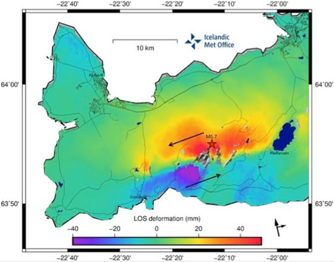
Satellite image of ground deformation associated with N-S and E-W movement on the Reykjanes Peninsula (image: IMO)

Distribution of the earthquakes on the Reykjanes Peninsula on 25 Feb (image: IMO)
The seismic activity started on 24 February accompanied by two moderate-to-strong volcano-tectonic earthquakes with magnitude M 5.0 and M 5.7 respectively and later that day another earthquake with magnitude M 4.8. Since the beginning of this unrest, 16 earthquakes above M 4 and 90 earthquakes above M 3 were detected by seismic network. The volcano-tectonic earthquakes were widely felt across SW part of the country including larger ones in the NW part as far as Ísafjörður.
A sharp peak in tremor was detected at 14:20 local time yesterday which has decreased and continued at reduced rate. The tremor was located 2 km southwest of Keilir on the Reykjanes peninsula.
There have been over 18,000 earthquakes at the time of this update since the seicmic activity started.
Significant ground deformation and location of the quakes in a N-S and E-W pattern suggests that a striking fault zone has been activated in this area. An InSAR interferogram showed left-lateral movement over a large section of the plate boundary.
The alert level for Krísuvík volcano was raised to "orange", as an increase of volcanic tremor has been recorded.
The ongoing elevated seismic swarm might be related with rock fracturing caused by a new batch of magma rising up to the surface. A new expected effusive eruption is likely upcoming in the next few hours.
Source: Icelandic Met Office volcano activity update 4 March 2021
- All news about: Krísuvík volcano
- Information about: Krísuvík volcano
Previous news
Wed, 3 Mar 2021, 06:00
Krysuvik-Trolladyngja volcano (Iceland) - Smithsonian / USGS Weekly Volcanic Activity Report for 3 March-9 March 2021 (New Activity / Unrest)
IMO reported that seismicity in the area between the Krýsuvík and Reykjanes-Svartsengi volcanic systems remained elevated during 4-10 March. GPS and InSAR data indicated that the intrusion was ongoing, with magma moving slowly SW along a fault between Keilir and Fagradalsfjall at depths of 2-6 km. Seismicity fluctuated during 6-7 March but continued to be elevated; the largest event was a M 5.1 on 7 March. ... Read all
Wed, 24 Feb 2021, 06:00
Krysuvik-Trolladyngja volcano (Iceland) - Smithsonian / USGS Weekly Volcanic Activity Report for 24 February-2 March 2021 (New Activity / Unrest)
IMO reported that seismicity in the area between Krýsuvík and Reykjanes-Svartsengi volcanic systems remained elevated during 26 February-1 March. More than 6,000 earthquakes had been detected after a M 5.7 event was recorded at 1005 on 24 February; two of those events were above M 5. The earthquakes were distributed over a 25-km-long section of a N-S striking fault along the E-W striking plate boundary, primarily located between Keilir and Fagradalsfjall. ... Read all
Show more